Mt. Robson, BC

Elements area

Taxonomy

Code

Scope note(s)

    Source note(s)

      Display note(s)

        Hierarchical terms

        Mt. Robson, BC

          Equivalent terms

          Mt. Robson, BC

            Associated terms

            Mt. Robson, BC

              2 Archival description results for Mt. Robson, BC

              2 results directly related Exclude narrower terms
              Group Photo
              2012.13.1.56.81 · Item · 1973
              Part of J. Kent Sedgwick fonds

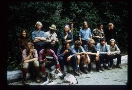
              Image depicts the hiking group. Kent Sedgwick is located in the back row, third from the left with a pipe.

              The Bourchier Album
              2009.5.3 · File · [ca. 1895 - 1950]
              Part of Taylor-Baxter Family Photograph Collection

              This photograph album consists of photographs of remote police barracks at Mile 47 and Mile 29; early settlements and/or mercantile stores at Tete Jaune Cache, McBride, Sand Creek, Fort George and South Fort George; Grand Trunk Pacific Railway forestry and railway camps; scows and paddlewheel conveyors on the Fraser River; automobiles; community leisure activities; as well as, images of the Bourchier family. The following South Fort George establishments are identifiable within these photographs: Empress Hotel, Ah Yee General Merchant, German Bakery, Northern Hotel, South Fort George Drug Store & Post Office, St. Michael’s Church, Prince George Hotel, Ford Monarch dealership, Astoria Hotel, and King George V Elementary School. Identified geographic locations featured in these photographs include: Tete Jaune, Upper Fraser, Mile 47, Mile 29, Fraser River, Mt. Robson, McBride, Sand Creek, Glacier Mountain, Moose River, Giscome Portage, Pott Falls, Red Deer River, Grand Canyon, Summit Lake, Canoe Pass, Connaught Hill, Nechako Bridge, and Island Cache.

              Bourchier, Alan K.