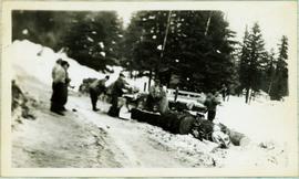
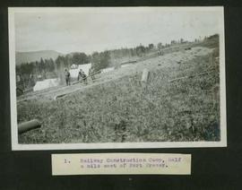
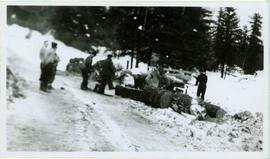
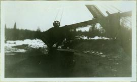
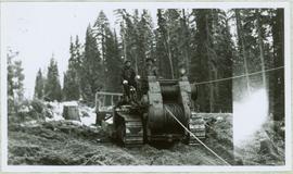
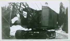
Photograph depicts the boom, stick, and bucket of a "Northwest" cable shovel loading a dump truck in excavation area, snow and forest in background.
Photograph depicts a group of men working with tools around thick logs, piles of firewood behind them. They are in a snowy area with trees in background.
Typed caption glued to album page directly below photograph reads: "3. Railway Grading at Fort Fraser." Photograph depicts steam train engine on a railway track behind several cargo cars filled with dirt and rock. Tents and wooden buildings under construction visible in background. Photographer: Dominion Stock & Bond Corporation.
Typed caption glued to album page directly below photograph reads: "51. Tract-laying west of Fort Fraser." Photograph depicts a man looking at a section of railway track, a large steam powered machine is in the background. Photographer: Dominion Stock & Bond Corporation.
Photograph depicts the Cassiar plantsite behind tailings pile in foreground. Mine road runs north though valley bellow mine, strip mining barely visible in background. Photograph was taken from above, facing north.
Photograph depicts view of pit mine, taken facing east. Town of Cassiar can be seen in distance at foot of south mountain range. Photograph was taken from the air, portion of plane visible in top left of image.
Photograph depicts benches after strip mining at Cassiar. Drill visible in distance, ore haul trucks on road in foreground.
Image of man seated with shovel in mountainous area, loose asbestos fibre in background. This photograph is believed to be either a double exposure of two images, or a print made from two negatives at once. Photo depicts an unidentified man sitting on the south ridge of the Cassiar ore body, where the crusher and rock reject plant would eventually sit. Valley in background appears to depict the "Footwall Road," which was cut into the mountain from the pit to the crusher plant and became the mine's main haul road.
Photograph depicts buildings near West Peak of Cassiar mine. Haul trucks parked near old mine garage in background, new mine garage and unknown buildings in foreground. Mine valley crosses midground, expansive western mountain range in background.
Photograph depicts unknown men driving bulldozers on edge of mine area at high elevation. Dozers are Internationals, model TD24 (manufactured between 1947 and 1955). Valley and mountain range in background.
Photograph depicts crawler cable shovel and dump truck in excavation area of mine. Handwritten annotation on verso of photograph: "1961".
Photograph depicts various buildings in plantsite, vehicles and electricity lines throughout. Equipment garage stands in left background behind tank farm, carpenter shop in right background, machine and electrical shop in building semi-visible on far right. Mine road can be seen at foot of mountain in background. Handwritten annotation on verso of photograph: "1961".
Photograph depicts a gravel road passing under crossing. Sign posted to pole reads "CAUTION TRAMLINE CROSSING CAUTION AVIOD PASSING UNDER MOVING BUCKETS". Garage stands in left midground, mountains in background. Handwritten annotation on verso of photograph: "1961".
Photograph depicts power house under construction. Temporary camp, service garage, and mountains in background. It is believed that this photograph was taken from top of the plant water tower.
Photograph depicts 4 men working on building speculated to be foundation for diesel engine. Oil tanks and mountains in background.
Photograph depicts mountain side mostly covered in snow. Corresponding note on accompanying photo description page: "10. Snow on mountain slope above road between where mountain road starts and the first switchback. This snow will melt and the water must still pass over or along road."
Photograph depicts a small building in airport yard at Watson Lake. Corresponding note on accompanying photo description page: "2. Lock stave building. Recently used as a residence and in good condition."
Photograph depicts a small building and large water tank at end of road in flat, wooded area at Watson Lake Airport. Truck to left, power poles barely visible in background. Corresponding note on accompanying photo description page: "6. Pump house and water tank. Contains both electric and diesel driven pumps all in excellent condition. Building locked."
Photograph depicts truck on right of large building in flat yard at Watson Lake. Corresponding note on accompanying photo description page: "8. Warehouse at Watson Lake owned by Cassiar. Located near Jac & Macs."
Photograph depicts 2 men working on building project, rocks and boulders in foreground, mountainside in background. Corresponding note on accompanying photo description page: "6. Making concrete form for first diesel engine, Two men in foreground."
Photograph depicts high snow bank on right, side of tractor plow on left. Mountainside in background. Corresponding note on accompanying photo description page: "3. Plowing snow on road to mine. This location is just past the Upper Camp. Our TD-14 tractor to left."
Photograph depicts snowy, cleared area bordered by dirt piles. Stakes visible in mid ground, trees and mountainside in background. Corresponding note on accompanying photo description page: "3. Survey stakes on power house site. Snow piles in background."
File contains photographs documenting the construction of Cassiar's new mill building. Photos depict early excavation, foundations, framework, construction of all seven stories, sheeting, siding, and roof tarring. Also included are photos depicting the large model of the mill, as well as construction work done on the tramline. Photos taken inside the mill depict flooring work, and milling machinery including feed chutes, screens, fans, wheelabrators, control panels, electrical panels, conveyor systems, vacuum systems, and the fan-driven air system that transported the fiber. Many photos depict construction workers, building supplies, worksites, and equipment including cranes, bulldozers, tractors, hauling trucks and trailer flatbeds. Some photos depict aerial views from the new mill and feature the plantsite, tramline, mine road, mountains, and valley.
Item is a photograph of the coffer dam built to isolate the construction site for the W.A.C. Bennett Dam.
Item is a photograph of a self-dumping log barge in action.
Typed caption glued to album page directly below photograph reads: "1. Railway Construction Camp, half a mile east of Fort Fraser." featuring nine unidentified men working on railway construction. Camp tents visible in background. Photographer: Dominion Stock & Bond Corporation.
Typed caption glued to album page directly below photograph reads: "11. Grading at Fort Fraser." Photograph depicts railway construction workers loading dirt and rocks from the track being laid, into cargo cars attached to a steam train engine. Photographer: Dominion Stock & Bond Corporation
Collection consists of 73 photographs featuring the construction of the John Hart Highway in Prince George, BC from 1945-1946. Images depict construction, machinery, workers, bunkhouses, persons, wildlife, and buildings all associated with this construction project around the Summit Lake region of the city.
John Hart HighwayWinter landscape scene featuring a small log home covered in snow with trees in background. Handwritten caption beside this photo reads: "Home of [Laral Peonen?] John Adams".
Handwritten caption above this photo reads: "Cutting Fire Wood". Photograph depicts two men on either side of large log using chain saw in wood clearing. A third man is watching them from behind the saw. A wood pile and small snow-covered building can be seen in background, as well as what is believed to be a caterpillar bulldozer.
View of summit lake from above, many small tree-covered islands and peninsulas visible. Handwritten caption beside this photo reads: "Sumit Lake".
Photograph depicts large fish laid next to a metal L ruler. Fish rests on dark wood speculated to be inside of boat or box of truck. It is believed this photo was taken at Summit Lake, B.C.
Handwritten caption above this photo reads: "Fred Youngstron[sic?]" "Foreman spotting for operator." Photograph depicts one man (Fred?) seated on D8 Caterpillar operating a haulback rig, and a second man standing beside him on the Caterpillar. Dirt and debris in foreground, forest in background. It is believed this rig is operating in a long-line skidding system.
Handwritten caption beside this photo reads: "Bear at the Dump". Photograph depicts a black bear facing the camera and sitting alert in clearing.
Photograph depicts tree shadows halfway up the steep slope of man-made embankment, forest in background. Tracks made my machinery are visible in dirt of the cut.
Handwritten caption above this photo reads: "Fred Youngstrom in [church shirt?]" Photograph depicts two men (Fred on left) standing on snow-covered road in front of car with a British Columbia license plate "93-650". A wood pile and long building with porch can be seen in background in front of forest trees. It is believed that this photo was taken at the camp in Summit Lake, B.C. (see item 2005.3.57).
Handwritten caption beside this photo reads: "Ned got a Moose". Photograph depicts a man named Ned holding the antlers on the head of a bull moose protruding from the fender of a car. Buildings and trees in background.
Handwritten caption above this photo reads: "Ned got a Moose" (see also item 2005.3.65). Photograph depicts the head of a bull moose protruding from the fender of a car. Buildings and trees in background.
Photograph depicts body of dragline crane in snowy area, trees, building, and other vehicles in background. A wood door or structure is semi-visible on far left.
Photograph depicts five long buildings in forest clearing, lining left of a road down the center of the image. Wood piles are stacked against buildings. Men can be seen in distance near a white tent.
Handwritten caption above this photo reads: "Making Fire Wood." Photograph depicts a group of men working with tools around thick logs, piles of firewood behind them. They are in a snowy area with trees in background.
The Mabel Rutherford Photograph Collection consists of 8 photographs depicting images of Red Rock and region: family, road and rail construction, landscape, farming equipment.
Rutherford, MabelRailroad ties beside a track waiting to be laid.
Four men stand around small car and one man rides in wagon, driving team of horses. Seven buildings can be see in background among trees.
Hugh and the children stand on railroad bridge. Opposite shore visible in background.
Unidentified man stands beside a car, to left of piles. Tarp covers portion of lumber pile. Log fence and trees in background.
Hugh Taylor Sr. stands between two horses, holding reigns. Hermina sits on left horse, Ellen and Violet sit in packboard on right horse. Five men sit on deck of large building with detailed porch in background on left. A fence, log shed, and wood pile can be seen in background on right. A dog stands beside Hugh. It is believed this photograph was taken at Hazelton, B.C.
Hugh Taylor Sr. stands between two horses, holding reigns. Hermina sits on left horse, Ellen and Violet sit in packboard on right horse. Five men sit on deck of large building with detailed porch in background on left. A fence, log shed, and wood pile can be seen in background on right. A dog stands beside Hugh. Handwritten annotation on verso of photograph: "Hazelton, B.C. 1910."
Photograph depicts bridge built with wooden planks and poles, with triangles built into its frame. Water rapids in foreground, opposite shore in background behind bridge. This is speculated to be one of the bridges that crossed the Hagwilget Canyon on the Bulkey River since 1859, five kilometres from its confluence with the Skeena River. See items 2009.5.1.69 - 2009.5.1.71.
Handwritten annotation on recto of photograph: "Omineca Dist Walcott Suspension Bridge West Approach - looking East May 26 - 1932". Photograph depicts two white horses pulling a wagon in front of Walcott bridge. This bridge was moved from its original location in the Hagwilget Canyon, downstream from Walcott on the Bulkley River. It is a pedestrian bridge at the time of this photograph, though it was originally used by motor vehicles. Dirt road leading to bridge in foreground, with lumber and brush piles on either side. Trees and hills on opposite shore in background.