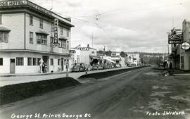
Street view photograph of a commercial section in downtown Prince George with several "Campbell's" delivery carts parked along the road. Visible establishments include "Campbell's All Cash Store" and "Club Cafe." Handwritten annotation in blue ballpoint pen on recto reads: "Howdy from Prince George! Going easy with all these kids- good to see Kathee. Snow here. Have fun at the sports show & don't over do it. Thinking of you guys, love Judy and Vic. P.S. Can't wait to go home to somewhere peaceful and quiet. 2-27-83." Postcard is addressed to: "Mr. & Mrs. Hauffer 8429-221 PL. Sn. Edmonds, WA. U.S. 98020." Verso is affixed with four Canadian 8-cent stamps.
Handwritten annotation on verso of photograph reads: "George St. Prince George BC Photo. S Wrathall". Prince George Hotel and Cafe stand on left side of street in foreground, and many other buildings and businesses can be seen. Vehicles line the street, cut banks visible in background. Photograph believed to have been taken while George Street was being prepared for a new lawyer of asphalt.
File contains slides depicting maps for land use in Prince George.
Photograph depicts rows of palm trees shadowing the Pacific Park Motel with a mountain range in the background.
Photograph depicts two unidentified, young First Nations girls standing hand in hand on a rocky beach. Rail tracks extending from the water to the shore are visible in the lower right corner and in the background. Handwritten annotation on verso reads: “Kingcome Reserve”
Photograph depicts a woman wearing a Cowichan sweater rowing a boat away from a rocky island with a lighthouse. Handwritten annotation in pencil on verso reads: “Gal in boat wearing Indian sweater knit by my mother Eileen M. Jackson (she also spun the wool) for her brother J.J. Claxton, cook on the Columbia Coast Mission Boat. - S.K. Jackson”
Photograph depicts a man on a boat standing with his back to the camera while holding a fishing rod. A waterfall and rocky cliff face are visible in the background. Handwritten annotation in pencil on verso reads: “Jim M.V. Columbia 1959”
Photograph depicts a Kwakiutl petroglyph exposed at low tide in Fort Rupert near Port Hardy. Handwritten annotations on verso read: “1957 Port Hardy, visible at low tide”; “Right negative, rock (?) Port Hardy visible at low tide”
Photograph depicts a Kwakiutl petroglyph in Fort Rupert near Port Hardy. Handwritten annotations on verso reads: “Reversed negative, dry rock, 1957”; “Dry Rock, 1957”
Photograph depicts a totem pole standing amidst a forested environment. Handwritten annotations on verso read: “Raven, ?, Sea Lions, Grizzly Bear, Dzondgwa”; “Kwakiutl Pole, Alert Bay & Fort Rupert” photographer’s stamp on verso: “W.E. Nicholson, 268 E. 10th, Vancouver 10, B.C.”
Photograph depicts a totem pole standing in front of a forested environment with a fence line in the foreground. Photographer’s stamp on verso: “W.E. Nicholson, 268 E. 10th, Vancouver 10, B.C.”
Photograph depicts a small totem pole in front of trees and a roadway. Photographer’s stamp on verso: “W.E. Nicholson, 268 E. 10th, Vancouver 10, B.C.”
Photograph depicts several carved totem poles and house posts in a clearing with a forested area in the background. Photographer’s stamp on verso: “W.E. Nicholson, 268 E. 10th, Vancouver 10, B.C.”
Photograph depicts a close-up of Alert Bay house posts adorned with First Nations carvings. Photographer’s stamp on verso: “W.E. Nicholson, 268 E. 10th, Vancouver 10, B.C.”
Photograph depicts five totem poles of various sizes in a fenced enclosure with a forested area in the background. Photographer’s stamp on verso: “W.E. Nicholson, 268 E. 10th, Vancouver 10, B.C.”
Photograph depicts a close-up of a totem pole behind a fence overlooking a wharf and a ship named Camosun. Photographer’s stamp on verso: “W.E. Nicholson, 268 E. 10th, Vancouver 10, B.C.”
Photograph depicts three young, First Nations girls standing in front of a memorial totem pole with houses and a forested environment visible in the background. Photographer’s stamp on verso: “W.E. Nicholson, 268 E. 10th, Vancouver 10, B.C.”
Photograph depicts a memorial totem pole in front of a fence line and a forested environment. Inscription on memorial pole states: “In loving memory of Tlaqwa Latle of the Qidwasudinuk Tribe, Died Nov. 9 - ” Photographer’s stamp on verso: “W.E. Nicholson, 268 E. 10th, Vancouver 10, B.C.”
Photograph depicts a man in uniform and a woman posing for a photo on a road situated between a fenced area featuring totem poles. Along the water’s edge in the background there is a float plane, wharf and the Camosun vessel. Handwritten annotation on verso reads: “Alert Bay B.C. Union Steamships Ltd.”; “Alert Bay BC”; photographer’s stamp on verso states: “W.E. Nicholson, 268 E. 10th, Vancouver 10, B.C.”
Photograph depicts James Joseph Claxton standing in front of a fence with a memorial pole in the background. The memorial pole depicts painted First Nations designs, with additional totem poles and houses visible in background. Handwritten annotation in pen on verso reads: “Jim Claxton 1959”
Photograph depicts a landscape shot of a body of water with mountains in background and forested shore in midground.
Photograph depicts a landscape shot of rushing water with a forested area in the background.
Photograph depicts a waterfall in a forested area with a riverbank in the foreground.
Photograph depicts four men in a boat on a lack with a waterfall in the background running through a forest into the lake. Annotation on verso of photograph states: "The water fall + flume for Brown's sawmill Hoscall River BC"
Photograph depicts piles of wood planks and log booms in the foreground with a waterfall in the background.
Photograph depicts two houses with snow-covered mountains in the background and a grassy yard in the foreground.
Map depicts the rivers, railways, and select lakes and towns located at Jasper Park between the northern boundary of the park and the townsite of Jasper. Part of the border between Alberta and British Columbia is visible on the west of the map.
Photograph depicts a snow-covered mountain slope with trees at the base of the mountain.
Photograph depicts one unidentified man surveying a landscape from a snowy mountain peak with other mountain ranges in the background.
Photograph depicts Roche Myette along Davona Creek near a campsite.
Photograph depicts a Rocky Mountain vista seen across a forested plateau.
Photograph depicts a vista from the Canadian Rockies with patches of snow.
Photograph depicts snow covered mountain peaks seen through a mountain pass near Jasper Park.
Photograph depicts a mountain goat standing at the edge of the striated and deeply cut banks of an unseen river with a forested area in the background.
Photograph depicts a mountain goat walking along a steep precipice.
Photograph depicts a craggy mountain peak covered with coniferous trees and snow.
Photograph depicts a river leading into a waterfall amidst snow-covered trees.
Photograph depicts the main street of Rolla with a dirt street and wooden sidewalks, tethered horses, and the storefront of H.G. Atkinson General Merchants. Three people are visible walking through the streets.
Photograph depicts the Peace River Canyon with the Peace River in the foreground and rocky, tree-lined cliffs flanking the river. In the background a forested mountain base is visible.
Series consists of print photographs created or collected by Gary Runka over the course of his personal and professional life. Includes school portraits, sporting event photographs, and work-related group portraits. Also includes aerial photographs of the West Coast Trail.
Air photograph depicts a segment of the West Coast Trail showing the beach area around the cabins at Nitinat Narrows. Coding on aerial is "BCO 390".
Air photograph depicts a segment of the West Coast Trail showing the beach area around the Carmanah Point Light Station. Coding on aerial is "BCO 391".
Air photograph depicts a segment of the West Coast Trail showing the beach area around Tsusiat Falls. Coding on aerial is "BCO 387".
Air photograph depicts a segment of the West Coast Trail showing the beach area around Tsusiat Point Hole in the Wall. Coding on aerial is "BCO 389".
Air photograph depicts a segment of the West Coast Trail showing the beach area around Tsusiat Falls. Coding on aerial is "BCO 388".
Map depicts forest and non-forest land on Vancouver Island.