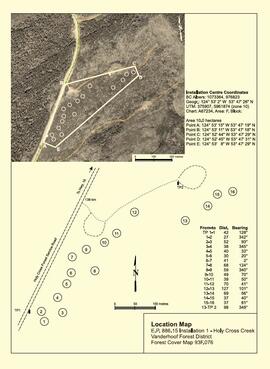
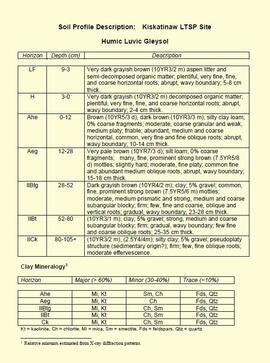
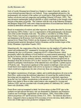
File contains handwritten cross section book, original studies with handwritten measurement charts and black and white photos, loose pages of original correspondence, handwritten diagrams and measurement charts, loose handwritten tally sheets, black and white photographs, hand coloured plot diagrams, photocopies of aerial photographs, and original correspondence for Plot 160.
File consists of:
- An original final draft of John Revel's problem analysis entitled "Silviculture in Spruce-Alpine Fir Types in the North Central Interior of British Columbia" for E.P. 639 with the Research Division of the BC Forest Service.
File consists of:
- "Devil's Club, Black Flies, and Snowshoes" by John Revel, 2007, 44 p. (3 copies)
File consists of:
- "A Summary of Historical Orders-in-Council affecting the Aleza Lake Forest Reserve", Mike Jull, 18 Dec. 1996
- Photocopied memorandum from F.S. McKinnon regarding "Transfer of Aleza Lake to D.F. Prince George", 9 Sept. 1963
- Photocopied 1928 article by P.M. Barr from Forestry Chronicle 4(3) entitled "The Aleza Lake Experiment Station: Its Development and Purpose"
- "A Brief History of the Aleza Lake Experiment Station", [Tim Decie, 1981?]
- Contact information for living relatives of Percy Barr, as of 1990
- Photocopy of 1930 article by Percy Barr entitled "Spruce Reproduction in British Columbia"
- Photocopy of records from BC Archives from a visit by Harry Coates from the file GR 1348 "The Young Mens Forestry Training Program"
- Photocopy of excerpt regarding "Amanita Lake/Diameter Limit Logging"
- Various small-scale maps and charts regarding Aleza Lake
- "Aleza Lake Research Forest Information Session Notes with Mike Jull, Manager of ALRF"
File contains drafts of management and working plan for the period of 1992 to 2002, the final draft for the management and working plan, and related correspondence between Mike Jull and those involved with the Aleza Lake Research Forest.
File contains a brochure, a 1993 solid waste management plan, a 1996 Forest Practices policy handbook, and a 1996 draft of the Prince George Land and Resource Management Plan.
File contains two different working and management plans for 1992 to 2002 as submitted by the Aleza Lake Steering Committee.
File consists of a transcript of an oral history interview with Jim Burbee.
File consists of a transcript of an oral history interview with the Perry Family.
File consists of a transcript of an oral history interview with Horst Sander. Also includes photocopies of Horst Sander's personal records, such as a tree farm license.
File consists of a transcript of an oral history interview with Bill Wade.
File consists of a transcript of an oral history interview with Ray Williston.
Maps reflect reserve boundary, roads, trails, 20 feet contour intervals, air photo centre, declination, swamps, and mile post.
File is a Resource Folio of maps and accompanying information created by Northwood Pulp & Timber regarding Timber Sale Harvesting Licence A01847, Willow River Block, Willow River P.S.Y.U. Includes maps that depict ungulates, waterfowl, recreation areas, special influence areas, and timber types. Most of the sheets have a duplicate, some with very slight variations. The following maps are supposed to be included in the but were missing upon arrival at the Archives: fish & topography, cutting permits & roads, and soils.
File contains datelines, small maps consisting of ecological site types, handwritten notes, overheads, terrain resource management information digital map data, and trail system maps.
"The Asbestos Sheet" is a newspaper that documents the community and work life of the residents of Cassiar BC. Content includes text and photographs, as well as jokes, comics, and games.
File consists of a transcript of an oral history interview with Ivan Andersen.
File consists of a transcript of an oral history interview with Earl Lousier and Harry Gairns.
Photographs are panoramas taken from the Churchill BC Forest Service Lookout, located at latitude 54°04' and longitude 122°16'. The photographs were bound together and include a transparent grid that was intended to be used for locating forest fires.
File contains typed file notes and charts of remeasured experimental plots, as well as a floppy disk
File consists of:
- David Mills, "Aleza Lake Research Forest Historical Internship Summary" (2 Jan. 2007), 26 p. - In print and original digital .doc file
- David Mills, "Aleza Lake Forest Experiment Station Socio-Economic Time Line 1905-1937" (2007), 68 p. - In print and original digital .doc file
- ALRFS employment paperwork for David Mills, the ALRFS Natural Resource History Intern
- Research notes, including a copy of a map of the town of Aleza Lake in the 1920s
File consists of memoranda from Per Saxvik to Bell-Irving regarding "Fraser River Flow Analysis with Reference to Fish Passage Capacity through the Main Fishways at Hell's Gate". Also includes a "Fraser River Canyon Fish Passage Summary Report (June 1988) Updated October 1989" by Per Saxvik of SEP Engineering.
Item is an original "Northern Interior Forest Experiment Station: Report of Preliminary Investigations" by Percy Barr. Includes original photographic prints.
During a year away from studies in 1987-88, Dr. Paul Sanborn developed a successful grant proposal to the Science Council of BC (SCBC) to pursue a postdoctoral project with Dr. Tim Ballard in relation to sulphur-deficient soils in BC and prescribed fire. This project built on an existing broadcast burning study conducted by Macmillan Bloedel Ltd. near Port Alberni on Vancouver Island, led by Bill Beese (later at Vancouver Island University). Dr. Sanborn's work addressed sulphur forms and amounts in the soils at these sites, and the chemical processes influencing sulphur availability in relation to prescribed fire.
Only one part of this work was eventually published:
Sanborn, P.T. and T.M. Ballard. 1991. Combustion losses of sulphur from conifer foliage: Implications of chemical form and soil nitrogen status. Biogeochemistry 12: 129–134.
https://doi.org/10.1007/BF00001810
The remainder of the work was documented in this Project Completion Report to SCBC, dated February 28, 1990, and entitled "Effects of Prescribed Fire on Sulphur in Forest Soils".
Sanborn, P. and R. Brockley. 2005. Sulphur deficiencies in lodgepole pine: occurrence, diagnosis, and treatment. Ext. Note 71. B.C. Min. For., Res. Br., Victoria, B.C.
Unpublished results for the Sulphur stable isotope tracer study (E.P. 886.15) were presented in annual reports to the funding agencies, including this FRBC 2001 Preliminary Final Report from April 2002.
Unpublished results for the Sulphur stable isotope tracer study (E.P. 886.15) were presented in annual reports to the funding agencies, including this FII Final Report from April 2003.
Unpublished results for the Sulphur stable isotope tracer study (E.P. 886.15) were presented in annual reports to the funding agencies, including this "Sulphur Fertilization of Lodgepole Pine: A Stable Isotope Tracer Study (Ministry of Forests E.P. 886.15) - Project Y051210 - Technical Report" from April 2005.
Unpublished results for the Sulphur stable isotope tracer study (E.P. 886.15) were presented in annual reports to the funding agencies, including this Final Technical Report from April 2007.
Document is a BC Ministry of Forests update on proposed research for the Sulphur stable isotope tracer study (E.P. 886.15) from March 1998.
Document is a research installation layout map for the Holy Cross Creek site of the Sulphur stable isotope tracer study (E.P. 886.15).
Document is a research installation layout map for the Kenneth Creek site of the Sulphur stable isotope tracer study (E.P. 886.15).
"Mineralogy of clay and sand fractions of soils developed from till, glaciofluvial and glaciolacustrine deposits in central interior British Columbia" was a preliminary internal report that provides some background to Arocena and Sanborn's regional soil mineralogy study, as well as a compilation of the mineralogical data.
The key results from this work were later published as:
J.M. Arocena and P. Sanborn. 1999. Mineralogy and genesis of selected soils and their implications for forest management in central and northeastern British Columbia. Canadian Journal of Soil Science 79: 571-592. https://doi.org/10.4141/S98-07
This Ministry of Forests internal memorandum of 30 June 1997 from Paul Sanborn to Regional & Research Branch soil scientists provides comparison of Morgan's extractant and BaCl₂ for cations, using the 57 samples from the regional soil mineralogy study.
The key results from the study were later published as:
J.M. Arocena and P. Sanborn. 1999. Mineralogy and genesis of selected soils and their implications for forest management in central and northeastern British Columbia. Canadian Journal of Soil Science 79: 571-592. https://doi.org/10.4141/S98-07
This "Soil Profile Description: Kiskatinaw LTSP Site" document provides a description of Kiskatinaw pedon.
The key results from the regional soil mineralogy study were later published as:
J.M. Arocena and P. Sanborn. 1999. Mineralogy and genesis of selected soils and their implications for forest management in central and northeastern British Columbia. Canadian Journal of Soil Science 79: 571-592. https://doi.org/10.4141/S98-07
This born-digital "Lucille Mountain soils" document provides a description and basic data for the Lucille Mt. pedon.
This born-digital "Profile Descriptions" document provides descriptions of Williams Lake (Skulow Lake), Aleza 1 & 2, Log Lake, and Lucille Mountain pedons.
This born-digital document provides a description of the Topley LTSP site pedon.
This born-digital document is an unpublished report to the Geological Survey of Canada on field work data and interpretations of Inlin Brook paleosols.
This born-digital document consists of field observations for Mackenzie Valley sites N04-06 to -08, Aug. 9-10.
Item is an original draft copy of "Regional Landscapes for the British Columbia Parks System".
Item is a reproduction of a report entitled "Burns Bog Analysis" by Catherine Berris & Associates for the Ministry of Environment, Lands & Parks. The scope of this Burns Bog Analysis was inventory and preliminary analysis; the process included information collection and review, preliminary analysis of existing and potential land uses and a public open house.
Item is a reproduction of a report entitled "Delta Nature Reserve: Evaluation Study Prepared for Delta Parks and Recreation". This study was intended to provide information and make recommendations regarding the optimum use of the property.
Item is an original report by Grant Hazelwood entitled "Mt. Assiniboine Park Trip, August 19-22, 1974". Includes original print photographs pasted into the report. The objective was to sample the lakes fishery at the south and north ends of the park and to examine some grizzly bear habitat on the Simpson River and examine the condition of guiding cabins in the same area.
File consists of an original draft copy of the "Kokanee Glacier Park Master Plan", as well as the "Background Report for Kokanee Glacier Park Master Plan" and the "Kokanee Glacier Park Master Plan: Public Handout and Questionnaire". These items are accompanied by correspondence related to the Master Plan.
Item is an original report by Grant Hazelwood and Steve Head regarding "Crooked River Fisheries and Wildlife". Includes one original photographic print pasted into the report. This project was aimed at improving the recreational use of the Crooked River and it's adjoining corridor.
Item is an original wildlife section report by F.H. Hartman entitled "Floristic Descriptions of Cover-types in Wells Gray Park".
Item is an original report by Teuvo Ahti entitled "Ecological Investigations on Lichens in Wells Gray Provincial Park, with Special Reference to their Importance to Mountain Caribou". Includes accompanying correspondence between Ahti and his BC Parks employers regarding travel and contract details.
Item is an original wildlife section report by R.W. Ritcey entitled "Predators in Wells Gray Park 1950-1956".