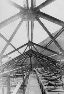
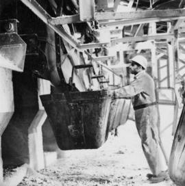
Photograph depicts a man in work clothes and hard hat standing with hands placed on the first of many tram buckets hanging in a line. Steel beam framework of station building rises above him. Handwritten annotation on recto of photograph: "[F1?] LOADING STATION EL. 5800". Photograph was glued to cardboard backing with the annotation: "1962".
File includes six aggregations of photographs which have been assembled in this file in order to maintain the integrity of each group by keeping the photos arranged together, though each group features operations pertaining to multiple files in this subseries. Includes groups featuring photos from 1961, 1965 1971, a helicopter trip, a community album, and a workplace album. Photographs depict images pertaining to the following operations at Cassiar, B.C.: mining, milling, maintenance, labratory tests, and tramline and town operations. Images featuring operations of the company town include the grocery store, bank, churches, school, library, lounge, pool, theater, community center, outdoor recreation, hospital, dentist, cafeteria, bus route, residences, air strip, firehall, laundromat, park, police, and newspaper.
Photograph depicts buildings at various locations in mine: crushing plant (centre?) and what is believed to be the original tramline loading station on left. Mine road featured in center, blasthole drill visible near dump truck in midground. Mine valley in background. Photo believed to have been taken from mine's South Peak. Handwritten annotation on verso of photograph: "1961".
Photograph depicts an Atlas Copco Drillmaster (blasthole drill) near the mine road, mountainside in background. This is a precision hammer drill which had its own power source. It is believed that this photo was taken on the North ridge, near the cirque dump. Handwritten annotation on verso of photograph: "1961".
Photograph depicts a man wearing a hard hat preparing explosive material, mountains in background. Dog stands near edge in midground, large bags of Ammonium Nitrate in right foreground. Handwritten annotation on verso of photograph: "1961".
Photograph depicts explosion, part of the bench-mining process employed at Cassiar. Handwritten annotation on verso of photograph: "1961".
Photograph depicts crawler cable shovel, bucket over box of Kenworth truck in excavation area of mine. Handwritten annotation on verso of photograph: "1961".
Photograph depicts a large shelter over building believed to be power house. Electricity lines cross midground and run to power house. A man can be seen crossing the foreground by steel frame supplies, and a second building is partially visible on right. Mountains stand in background and a crane can be seen operating in front of power house. Handwritten annotation on verso of photograph: "1961".
Photograph depicts the diesel-fired burners of the ore dryers. The large pipes and valves above were part of the fuel supply system fed by Cassiar's fuel tank farm which also supplied the power house generators. The dryer section of the mill received ore from the crushing plant by tramline and truck. These burners blasted the ore with hot air, and dried ore to desired moisture content before it was sent to the dry rock storage building and stored for mill use. Handwritten annotation on verso of photograph: "1961".
Photograph depicts a truck on a newly cleared dirt road in a mountain pass and a wooded area.
Photograph depicts a wooden structure in a gravel landscape. Truck with open door in foreground, forest and snow capped mountains in background. Mounds of gravel visible behind structure.
Photograph depicts the wooded area of the Cassiar valley. The projected plant site is outlined in blue ink. Trees and bushes in foreground, snow-capped mountains in background.
Photograph depicts approximately six lumber piles in the northwest corner of snow-covered plant site. Forest and snow-capped mountains in background. Photo taken facing west.
Photograph depicts tent structures among trees at the temporary Cassiar construction camp. Taken from future site of garage building, looking northwest, snow-capped mountain in background.
Photograph depicts three men building garage foundation in snow-covered plant site. Truck to right of men, wood fence structure in foreground, Asbestos Valley in background.
Photograph depicts a wet mud road in forest. Truck and people on left in distance, one man in foreground on right.
Photograph depicts a wet mud road in forest. Truck in distance, woman and shadow of unknown person in foreground.
Photograph depicts a truck and two men on a wet mud road in forest. Photo taken from side of road, road in foreground, trees in background.
Photograph depicts two men in front of truck on a wet mud road in forest. Road in foreground, one man in shade on left, trees in background.
Aerial photograph of Clinton Creek, south east of plant site.
Aerial photograph of Clinton Creek, north west of plant site.
Aerial photograph of Clinton Creek, south west of plant site.
Aerial photograph of Clinton Creek, west of plant site.
Aerial photograph of Clinton Creek, north west of plant site.
Aerial photograph of Clinton Creek, north of plant site.
Aerial photograph of Clinton Creek, south of plant site.
Aerial photograph of Clinton Creek, south west of plant site.
Aerial photograph of Clinton Creek, west of plant site.
Aerial photograph of Clinton Creek, south of plant site.
Aerial photograph of Clinton Creek, east of plant site.
Photograph depicts Cassiar's Chief Geologist Bill Plumb and unidentified man standing on shore by yellow Cassiar supervisor's truck. Airplane is parked on lake behind them, and miscellaneous equipment lies on shore at Bill's feet. Photograph speculated to have been taken at Aeroplane Lake, approximately 35 miles east of Cassiar. Bill Plumb led many expeditions for the purposes of Cassiar's outside exploration endeavours.
Photograph depicts a geologist's hammer, believed to belong to Cassiar's Chief Geologist Bill Plumb. The hammer provides a scale for the exposed asbestos, indicating the percent of fibre in the rock as well as the expectation of grade.
Photograph depicts freight truck being ferried across the Stewart River, north bound. It is believed that this truck may have been owned by United Keno Hills Mines Ltd. It is speculated that this photograph was taken for research purposes.
Photograph depicts a transport truck being loaded with concentrates of silver-lead and zinc ores at Elsa Mill, Mayo Mining district, Y.T (owned by United Keno Hill Mines Ltd.). It is speculated that this photograph may have been kept for research purposes.
Photograph depicts two miners loading holes for blasting high grade rock face in the Hector mine (owned by United Keno Hill Mines Ltd.). It is speculated that the photograph may have been kept for research purposes.
Photograph depicts the Calumet townsite owned by United Keno Hill Mines Ltd. Photograph faces east, tramline beneath mine tailings pile runs to the Elsa mill. It is speculated that the photograph may have been kept for research purposes.
Photograph depicts top of framed building, mountain in background.
Photograph depicts dump truck on hill believed to be in mine area, unknown structure on left.
Photograph depicts tarp-covered truck, two men on right, mountains in background.
Photograph depicts bridge crossing river, trees in background.
Photographs depict electrical room.
Photograph depicts bridge in snow landscape, trees in background. Corresponding note on accompanying photo description page: "March 29th: 2. Timber bridge at the Blue River."
Photograph depicts bunkhouse under construction in wooded area, men in foreground. Corresponding note on accompanying photo description page: "April 7th: 5. Erecting the walls for # 1 Bunkhouse. Looking east."
Photograph depicts snow-cleared dirt area, trees in background. Corresponding note on accompanying photo description page: "April 7th: 10. Site for townsite well cleared and started excavating."
Photographs depict electrical room.