Showing 265 results

Archival description
Hudson's Hope
2000.19.2.33 · Item · 29 Aug. 1927-26 Sept. 1927
Part of Prentiss Gray Collection

Photograph depicts the townsite of Hudson's Hope featuring a number of small wooden buildings clustered in a field. The Hudson's Bay post is building visible on far left.

2020.4.2.1.04 · File · 15 Mar. 1971
Part of G. Gary Runka fonds

File consists of a speech given by Gary Runka at UBC entitled "Integrated Land Use - BC Experience".

Commentary on this speech by Barry Smith of the Ministry of Agriculture and Lands:
"The speech provides insight into GGR's concept of integrated land use as opposed to multiple land use.

Agriculture noted as often the 'primary use for land designated in the ALR'. On page 5 GGR reflects on this concept when stating that integrated land use planning is a useful first step "... to indicate the primary physical capability of each landform based on inherent soil and climatic characteristics".

The speech was accompanied by slides."

2020.05.41 · Item · 1936
Part of Gordon Wyness Album

Photograph depicts Jack Lee (front) and Gordon Wyness drinking lakeside in Marble Canyon. The survey crew had been travelling along Marble Canyon Road, which is now Highway 99. The lakes in Marble Canyon are now named Turquoise Lake, Crown Lake, and Pavilion Lake. Wyness notes the blueness of these lakes and the white mountains of this area.

2020.05.52 · Item · 1936
Part of Gordon Wyness Album

Photograph depicts (from left) Jack Lee and Gordon Wyness sitting on a car next to their equipment while surveying at an Indian Reserve. A cabin on the reserve is also depicted. According to the transcription on the photograph verso, they were surveying road through an "Indian Reserve South of South bank François Lake".

2020.05.54 · Item · 1936
Part of Gordon Wyness Album

Photograph depicts (from left) Jack Lee and Philip Monckton leaning up against their 1930 Buick Series 40 car before leaving for Southbank Francois Lake. Behind them is the cabin they stayed in at Burns Lake, which was owned by Ben[?] Smith.

2020.05.17 · Item · [Sept. or Oct. 1936]
Part of Gordon Wyness Album

Photograph depicts Jack Lee rafting with a sail on Bobtail Lake, as he was going over to other side of the lake to locate traverse posts (without success, according to the annotation on the photograph verso).

2020.05.13 · Item · [Sept. or Oct. 1936]
Part of Gordon Wyness Album

Photograph depicts (from left to right) Jack Lee, Gordon Wyness, Jessie McInnes, and Archie McInnes at Pioneer Ranch.

In 1903, brothers Neil and Archie McInnes pre-empted a section of land two miles east of Cote Flat, each taking half. Archie McInnes' land later became known as Pioneer Ranch (later known as the Barnett Ranch); Neil McInnes' land became Meadowbrook Ranch. Archie McInnes married Jessie Aitken in October 1905. Pioneer Ranch became known as a stop-over for travellers en route from Hazelton to the Ootsa Lake area via the Telegraph Trail. Archie and Jessie McInnes had three daughters: Vera (m. Ivan Frank), Ivy (m. Eric Strimbold), and Neva (m. John Ivan Nickolichuk).

2020.05.14 · Item · [Sept. or Oct. 1936]
Part of Gordon Wyness Album

Photograph depicts (from left to right) Jack Lee, Philip Monckton, Jessie McInnes, and Archie McInnes at Pioneer Ranch.

In 1903, brothers Neil and Archie McInnes pre-empted a section of land two miles east of Cote Flat, each taking half. Archie McInnes' land later became known as Pioneer Ranch (later known as the Barnett Ranch); Neil McInnes' land became Meadowbrook Ranch. Archie McInnes married Jessie Aitken in October 1905. Pioneer Ranch became known as a stop-over for travellers en route from Hazelton to the Ootsa Lake area via the Telegraph Trail. Archie and Jessie McInnes had three daughters: Vera (m. Ivan Frank), Ivy (m. Eric Strimbold), and Neva (m. John Ivan Nickolichuk).

2001.1.1.2 · Item · 31 Jan. 1869
Part of NBCA Document and Ephemera Collection

Item consists of a letter written by John McCormick to a person named James; it is not made clear if James is a friend or relative. In both his letter to James, John McCormick makes several references to Victoria. His familiarity with Victoria suggests that he may have travelled from Victoria to Barkerville to mine for gold. In his letters to James, John McCormick describes having no money and living under poor conditions. He mentions the great fire that swept through Barkerville and that he lost nothing due to its distance from his house. McCormick also mentions that the Indians are dying quickly of Small Pox in Victoria.

2020.4.2.1.03 · File · 19 Oct. 1970
Part of G. Gary Runka fonds

File consists of a speech given by Gary Runka to the Canada Soil Survey Committee in Ottawa entitled "Land Capability Analysis".

Commentary on this speech by Barry Smith of the Ministry of Agriculture and Lands:
"This is a fairly technical speech explaining the history, and mechanics of the evolving land capability analysis process in BC. It gives insight into this early period in which there was a fair amount of trial and error to develop the best techniques to display and utilize information.

From an agricultural perspective the speech notes (p.5) that compatibility between agriculture and other sectors is not high. The speech demonstrates what would emerge as an important link between Land Capability Analysis and the ALR. On page 7 "possible predictions that will result in land use conflicts but perhaps better long range planning" are insightful and in the case of this statement, reads like a tentative foreshadowing of the BC farmland preservation program that would emerge in about two years.

"(1) Agriculture - "(c) Conservation of agricultural land through rural zoning of those high capability and high productivity soils, near markets."

It is unknown if the use of the acronym C.S.S.C was intended to refer to the "Canada Soil Survey Committee", which held its eighth meeting in Ottawa in 1970, or to the "Canadian System of Soil Classification. Regardless, for more information on the subject a copy of the 1998 / 187 page report by the Soil Classification Working Group entitled, "The Canadian System of Soil Classification" can be found here: https://sis.agr.gc.ca/cansis/publications/manuals/1998-cssc-ed3/cssc3_manual.pdf "

2020.4.4.37 · File · 1974
Part of G. Gary Runka fonds

File consists of a 1973 BC Land Commission photographic slide and audio tape set entitled "Land Commission Act and the Agricultural Reserve Plan" that was used in original public hearings throughout the province. The 80 slides included with the presentation materials were created mostly by Gary Runka. The audio cassette is a recording of the presentation with speakers Bill Lane, BC Land Commission Chair, and Gary Runka, BC Land Commission General Manager.

2020.4.2.1.45 · File · Dec. 1980
Part of G. Gary Runka fonds

File consists of a speech given by Gary Runka entitled "Land Resource Issues in BC and the Tough Choices Ahead" for the Surrey Rotary.

Commentary on this speech by Barry Smith of the Ministry of Agriculture and Lands:
"This speech, with the exception of the beginning and the ending is largely the cobbling together of two previous speeches. The new introduction draws upon several headlines from contemporary newspaper articles as examples involving land and water use decision-making. The next several pages largely repeat portions of [2020.4.2.1.42] "The Rural - Urban Continuum: Tough Land Use Choices Ahead". The latter half of the speech draws from [2020.4.2.1.44] "Land Resource Issues in B.C. - UBC Seminar".

The speech ends with a suggestion that there is a faint light at the end of the tunnel offered by the proposed "Planning Act". The speech closes with 3 broad concepts for consideration:

  1. Land and water use planning is fundamental in determining the economic opportunity and environmental quality of the future;
  2. Good rural planning demands good urban planning and the race for space will accelerate; and
  3. There is a need to reflect on the interdependence of man within natural systems in our planning for rural and urban land and water.

While farmland preservation isn't central to this speech the rural resource and planning theme is relevant."

2020.4.2.1.44 · File · Nov. 1980
Part of G. Gary Runka fonds

File consists of a speech given by Gary Runka entitled "Land Resource Issues in BC" at a UBC seminar.

Commentary on this speech by Barry Smith of the Ministry of Agriculture and Lands:
"This speech / paper asks the question, "Are we in fact making any real progress towards resolving .... land resource conflicts...?"

A discussion is introduced that land resource issues are rural planning issues and as such they impact rural people and their lifestyle and thus translate to lifestyle issues. GGR suggests that planners are urban oriented and they should stand on the rural side of the fence and look back at the urban areas rather than the other way around.

Too often in government an agency's interests are paramount and insist that others tag along as long as they don't interfere with the prime use thrust. A concern is also expressed with "...too many waves of single use legislative power coming to the fore..." It is noted that the "...goal of any regulatory program should be to protect important public interests."

The paper concludes by considering a few current land resource issues including:

  1. Forestry-Agriculture
  2. Grazing land tenure transfer
  3. Fisheries - Agriculture - Forestry - Urban
  4. Energy - Agriculture
  5. Urban-Rural
  6. Energy-Lifestyles
  7. Wildlife - Recreation - Energy
  8. Agriculture and Recreation Lands - Foreign Ownership and Influence

While farmland preservation isn't central to this speech the rural resource and planning theme is relevant."

2020.4.2.1.12 · File · 7 Nov. 1974
Part of G. Gary Runka fonds

File consists of a speech given by Gary Runka to the Agricultural Institute of Canada Land Use Committee entitled "Land Use Control and Jurisdictional Rights".

Commentary on this speech by Barry Smith of the Ministry of Agriculture and Lands:
"This is a first draft position paper written by GGR was developed for the Agricultural Institute of Canada, Land Use Committee.

The paper notes that attitudes are shifting from land being considered as a commodity to considering land as a natural resource. There are several references to governmental relationships, the inability to count on local governments to preserve agricultural land and the need for a federal land use policy supporting farmland preservation.

The use of a zoning tool as an effective means to preserve agricultural land is explored. The paper makes a strong case for there being no legal need for compensating land owners for regulatory land use zoning.

Included with the package are two letters written by GGR (November 7,1974) sent to Jim Lore (Alberta) and Steve Hart (Ottawa) requesting their review of the paper and input. A copy of the finalized paper, which may have been a jointly authored paper, is not included and it is not known if the paper was eventually published by the Agricultural Institute of Canada."

2020.4.2.1.17 · File · 29 Sept. 1976
Part of G. Gary Runka fonds

File consists of a speech given by Gary Runka to the Canadian Council on Rural Development entitled "Land Use Control".

Commentary on this speech by Barry Smith of the Ministry of Agriculture and Lands:
"This is another important document.

GGR covers several points including a discussion of the impact of changes to rural areas from the food producer's perspective. He notes that local governments are not well positioned to effectively achieve farmland preservation - but there is a need for a coordinated approach.

The point is made that good rural planning depends on good urban planning.

A summary is made of efforts at rural planning and farmland preservation in other North American jurisdictions. An example is outlined of the complexity of overlapping land use controls and returns to a common theme - "merging the reality of land as a commodity with the ethic of land as a natural resource"."

2020.4.2.1.24 · File · 2 Mar. 1978
Part of G. Gary Runka fonds

File consists of a speech given by Gary Runka to the BC Provincial Seed Fair in Fort St. John entitled "Land Use Planning and the Farmer".

Commentary on this speech by Barry Smith of the Ministry of Agriculture and Lands:
"Given the title and the audience, this speech reads like a wake-up call to farmers to pay attention to land use planning issues and get involved. Despite the available copy of the speech appearing as a draft the nature of the topic - farmers needing to get involved in land use planning - establishes a point that GGR obviously feels is important in the overall effort to preserve agricultural land.

The speech includes several examples of land use planning that can affect the agricultural industry including:

  • Rural zoning by local governments and the provincial ALR zoning;
  • Hydro-electric planning (a reference in all probability to Site C);
  • Preparation of regional, community and particularly settlement plans;
  • Industrial land development strategies;
  • Federal fisheries legislation;
  • Transportation planning;
  • Crown land lease proposals;
  • Water resources;
  • Various other land use initiatives involving wildlife habitat, open space recreation, historic and archeological sites; and
  • Taxation and assessment policy

Stapled to the original typed speech is a set of hand written notes (not copied) that are largely identical to the typed version. The typed version does have a few mysterious blanks but when checking the handwritten version the blanks may simply represent illegibility problems with the hand writing at the time of typing. Given these blanks, this may in fact have been a first draft of the speech with a cleaner copy typed up prior to delivery."

2020.4.2.1.33 · File · Jan. 1979
Part of G. Gary Runka fonds

File consists of a speech given by Gary Runka entitled "Land Use Planning and the Nursery Trades" to the BC Nursery Trades Association.

Commentary on this speech by Barry Smith of the Ministry of Agriculture and Lands:
"The primary thrust of the speech is to outline several pieces of legislation and other land uses that may have an impact on the nursery trade use of land including:

  1. Federal Fisheries Act;
  2. Municipal & regional district bylaws and plans;
  3. Agricultural Land Commission Act;
  4. Soil Conservation Act;
  5. Water Act and Floodplain Regulation;
  6. Forest and Range Acts; and
  7. Your neighbours changing land-use activities.

GGR comments (p 2) that, "...exclusion (of land from the ALR) is only allowed on lands not capable of agricultural use where no impact would be effected on adjacent farmlands, or where absolutely no alternative for the alternate use proposed exists." This clarifies that land in the ALR, even if it is proven unsuitable for agriculture, may remain in the ALR if its exclusion impacts adjacent farmland. On the other hand, pressure on the ALR is acknowledged where claims can be successfully mounted that no alternative exists for a proposed use, demonstrating the continual vulnerability of the ALR and the need to be able to clearly assess claims of "no alternative".

Foreshadowing the need for agricultural area planning, GGR suggests (p. 3) that it is important that, "... attempts be made to encourage local agricultural use planning so as to reduce conflicts within agriculture and with your urban neighbours."

2020.4.2.1.09 · File · 1974
Part of G. Gary Runka fonds

File consists of a speech given by Gary Runka entitled "Land Use Planning as it affects the Vegetable Industry".

Commentary on this speech by Barry Smith of the Ministry of Agriculture and Lands:
"GGR gives this speech as a representative of the B.C. Land Commission and is directed at vegetable industry reps.

The ALR is mentioned a number of times and it is noted that only 1 - 2% of BC is suitable for vegetable production. Several examples (8) of pressures on agricultural land are given.

GGR draws his audience's attention to the impact of speculation when stating:
"Substantial capital gain from land development or speculation unfortunately can to some degree subvert even the best planning. .... Fortunately, this type of speculation is now on somewhat shaky ground because of the Land Commission Act in B.C."

The overall message is that vegetable producers should involve themselves in land use planning."

2020.4.2.1.62 · File · [June 1994]
Part of G. Gary Runka fonds

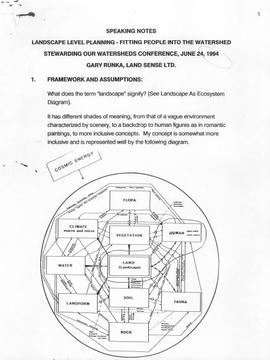
File consists of a speech given by Gary Runka entitled "Landscape Level Planning - Fitting People into the Watershed" at the Stewarding Our Watersheds Conference.

Commentary on this speech by Barry Smith of the Ministry of Agriculture and Lands:
"The first half of this speech takes a very broad sweep in defining landscape units and the provincial planning system. In the second section "Entering the People Use Maze", the paper focuses more locally on the Salmon River watershed and discusses the findings of a survey associated with the Langley Rural Plan.

The survey results demonstrated that for both rural and non-rural residents in Langley, 'the country atmosphere' was why they had chosen to live in Langley. Residents also disagreed with the statement that it was unpleasant to live in an agriculture area.

The third section - "Techniques of Integrating Balanced, Sustainable People Use" into the Watershed" considers eight tools that will assist achieving "landscape level" planning, one of which is the ALC Act.

Besides these direct references to agriculture, country atmosphere and ALC Act; the Langley Rural Plan drew heavily on the survey that GGR refers to and the Plan, which was largely comprised of agricultural lands, was inspirational in the development of the Commission of work "Planning for Agriculture".

Lone Butte, BC
2020.05.22 · Item · Oct. 1936
Part of Gordon Wyness Album

Photograph depicts a view of Lone Butte, BC. The butte formation of the same name (Lone Butte) is visible in the background; a ranch or residence is visible in the foreground. Wyness notes that Lone Butte was the "last one [they] tied in". "Tying in" is a land surveying technique. Since the photograph is dated October 1936 and Wyness described the survey trip as lasting June 5 - October 8, 1936, that implies that Lone Butte was the last location they surveyed on this trip.

2020.05.06 · Item · October 1936
Part of Gordon Wyness Album

Photograph depicts Mount Begbie, noted by Wyness to be the highest point on the Cariboo Highway at mile 85. Mount Begbie is located at approximately 51°28'33''N, 121°22'00''W, on the east side of Cariboo Hwy, between 70 Mile House and 100 Mile House, in the Lillooet Land District. Also visible in this photograph is the Cariboo Highway road.

2020.05.07 · Item · October 1936
Part of Gordon Wyness Album

Photograph depicts Mount Begbie, noted by Wyness to be the highest point on the Cariboo Highway at mile 85. Mount Begbie is located at approximately 51°28'33''N, 121°22'00''W, on the east side of Cariboo Hwy, between 70 Mile House and 100 Mile House, in the Lillooet Land District. Also visible in this photograph is the Cariboo Highway road.