Showing 190 results

Archival description
190 results with digital objects Show results with digital objects
2020.05.14 · Item · [Sept. or Oct. 1936]
Part of Gordon Wyness Album

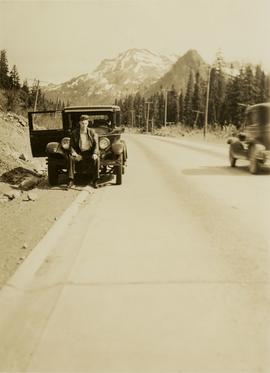
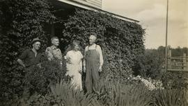
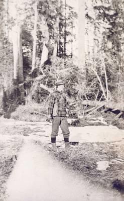
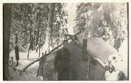
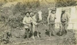
Photograph depicts (from left to right) Jack Lee, Philip Monckton, Jessie McInnes, and Archie McInnes at Pioneer Ranch.

In 1903, brothers Neil and Archie McInnes pre-empted a section of land two miles east of Cote Flat, each taking half. Archie McInnes' land later became known as Pioneer Ranch (later known as the Barnett Ranch); Neil McInnes' land became Meadowbrook Ranch. Archie McInnes married Jessie Aitken in October 1905. Pioneer Ranch became known as a stop-over for travellers en route from Hazelton to the Ootsa Lake area via the Telegraph Trail. Archie and Jessie McInnes had three daughters: Vera (m. Ivan Frank), Ivy (m. Eric Strimbold), and Neva (m. John Ivan Nickolichuk).

2001.1.1.2 · Item · 31 Jan. 1869
Part of NBCA Document and Ephemera Collection

Item consists of a letter written by John McCormick to a person named James; it is not made clear if James is a friend or relative. In both his letter to James, John McCormick makes several references to Victoria. His familiarity with Victoria suggests that he may have travelled from Victoria to Barkerville to mine for gold. In his letters to James, John McCormick describes having no money and living under poor conditions. He mentions the great fire that swept through Barkerville and that he lost nothing due to its distance from his house. McCormick also mentions that the Indians are dying quickly of Small Pox in Victoria.

Lone Butte, BC
2020.05.22 · Item · Oct. 1936
Part of Gordon Wyness Album

Photograph depicts a view of Lone Butte, BC. The butte formation of the same name (Lone Butte) is visible in the background; a ranch or residence is visible in the foreground. Wyness notes that Lone Butte was the "last one [they] tied in". "Tying in" is a land surveying technique. Since the photograph is dated October 1936 and Wyness described the survey trip as lasting June 5 - October 8, 1936, that implies that Lone Butte was the last location they surveyed on this trip.

2020.05.06 · Item · October 1936
Part of Gordon Wyness Album

Photograph depicts Mount Begbie, noted by Wyness to be the highest point on the Cariboo Highway at mile 85. Mount Begbie is located at approximately 51°28'33''N, 121°22'00''W, on the east side of Cariboo Hwy, between 70 Mile House and 100 Mile House, in the Lillooet Land District. Also visible in this photograph is the Cariboo Highway road.

2020.05.07 · Item · October 1936
Part of Gordon Wyness Album

Photograph depicts Mount Begbie, noted by Wyness to be the highest point on the Cariboo Highway at mile 85. Mount Begbie is located at approximately 51°28'33''N, 121°22'00''W, on the east side of Cariboo Hwy, between 70 Mile House and 100 Mile House, in the Lillooet Land District. Also visible in this photograph is the Cariboo Highway road.

2009.7.1.265 · Item · 24 April 1913
Part of Archdeacon W. H. Collison fonds

Photograph of a large explosion on a rocky shoreline. A bridge is visible in the foreground and a body of water is partially visible in the background. Annotation on recto reads: "McRae Bros Moving Mountains at Prince Rupert BC Apr 24th"

2011.3.3.86 · Item · 17 July 1913
Part of North Coast & Central BC Postcard Collection

Photograph of a large explosion on a rocky shoreline. A bridge is visible in the foreground and a body of water is partially visible in the background. Printed annotation on recto reads: "McRae Bros Moving Mountains at Prince Rupert BC Apr 24th" Handwritten annotation on verso reads: "Rupert. July 17 1913. Dear [illegible]. Just a card for that album if you've got any room left by now. This is one of the blasts for the clearing of the drydock up here. [Illegible] W.M." Postcard is addressed to: "Miss C.M. Ranip[??] 931 Northlane Av.[sic] Seattle Wash." Two Canadian one cent stamps are affixed on verso. Postmark reads: "Prince Rupert BC. PM Jul 17 13."

2020.05.05 · Item · October 1936
Part of Gordon Wyness Album

Photograph depicts Mount Begbie, noted by Wyness to be the highest point on the Cariboo Highway at mile 85. Mount Begbie is located at approximately 51°28'33''N, 121°22'00''W, on the east side of Cariboo Hwy, between 70 Mile House and 100 Mile House, in the Lillooet Land District. Wyness annotated this photograph with the statement that they "tied this one in"; 'tying in' is a land survey term, implying that the crew may have also been surveying in this area.

2009.7.1.277 · Item · [ca. 1880-1920]
Part of Archdeacon W. H. Collison fonds

Wide angle photograph of many buildings scattered in a clear cut area. Foreground shows several businesses, including "Kelly Carruther's Supply" and "Prince Rupert Hardware and Supply Co." Some remaining forest is visible in the background. Annotation on recto reads: "Prince Rupert, BC 1659."

2009.7.1.281 · Item · [ca. 1880-1920]
Part of Archdeacon W. H. Collison fonds

Wide angle photograph of Prince Rupert sometime during the winter. There is snow on the ground and a marge mountain range is visible in the background. Annotation on recto reads: "Prince Rupert looking East from Waterworks J.D.A Pho 5/2."

2009.7.1.247 · Item · ca. 1880-1920
Part of Archdeacon W. H. Collison fonds

Photo of entire ship building plant, including several vessels in the foreground. Hills are visible in the background. Annotation on recto reads: "Prince Rupert Ship Repair and Ship Building Plant. Prince Rupert BC. Frank E Kirby, William T Donnelly, Engineers. 17 Battery Place. NYC."

2009.7.1.273 · Item · [ca. 1880-1920]
Part of Archdeacon W. H. Collison fonds

Photograph of a small vessel on the ocean with a dock and harbour buildings in the foreground. Tents and piles of lumber can be seen among the buildings. Annotation on recto reads: "The Wharf, Prince Rupert, BC. 1657." Printed annotation on verso reads "The Wharf, Prince Rupert, BC J. Howard A. Chapman, Victoria. BC. 1657."

2009.5.2.8 · Item · [ca. 1911]
Part of Taylor-Baxter Family Photograph Collection

Photograph depicts Sarah Glassey, holding her fox terrier, and standing at corner of log house. Felled trees in foreground, forest trees in background. Photograph believed to have been taken on the 160 acres of land which Sarah purchased in the Kispiox Valley in 1911. She became the first single woman to pre-empt land in British Columbia. This house was built in a year with the help of a Gitxsan Elder.

2006.20.11.2 · Item · [ca. 1900]
Part of Northern BC Archives Historical Photograph Collection

Photograph depicts a street scene along Second St. in Fort George. Wagons line the dirt road which is flanked by wooden buildings. A group of unidentified men stand on the boardwalk outside of Rigg's Restaurant. Handwritten annotation along bottom of photograph: "Second St. Ft. George".

2009.7.1.274 · Item · May 1908
Part of Archdeacon W. H. Collison fonds

Side view photograph of a small harbor close by a shoreline littered in organic debris. A foggy mountain range is visible in the background. Annotation on recto reads: "Wharf and Harbor Prince Rupert. May 1908 JDA."

Snoqualmie Pass summit
2020.05.01 · Item · 6 June 1936
Part of Gordon Wyness Album

Photograph depicts a man, likely Gordon Wyness, sitting on the front of a 1930 Buick Series 40 car at the Snoqualmie Pass summit.

2009.7.1.267 · Item · 30 March 1914
Part of Archdeacon W. H. Collison fonds

Photograph of ocean liner SS Arna docked in a harbour. Foreground shows two individuals on a dock in the lower right corner and a large pile of lumber in the lower left corner. Annotation on recto reads: "S.S. Arna arrived in Prince Rupert B.C March 30th 1914"