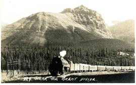
Postcard depicts the Illecillewaet Valley, near Glacier, BCThe view shows the end of the descent over Rogers Pass, if travelling westerly. The scar in the foreground was believed to be the track between the 1st (Glacier Hotel) and 2nd (Loop Brook) loops.
Postcard depicts "The Loop," CPR, Selkirk Mountain.
Postcard depicts the west portal of the Connaught Tunnel, near Glacier, BCDavies noted the ventilation engine house above the entrance.
Postcard depicts the Kamloops CPR depot and gardens.
Postcard depicts Main Street (Victoria West) Kamloops in 1910.
Postcard depicts a "4-4-0 woodburning locomotive at Shuswap Station, east of Kamloops, at the turn of the century. The completion of the CPR across the Continent, guaranteed B.C.'s entry into Cinfederation, as well as reg economic and cultural connection to the East."
Postcard depicts Cathedral Mountain on the Canadian Pacific Railway.
Postcard depicts the Lake Louise CPR depot.
Postcard depicts Field station in the Rockies. Man standing on the left with a bowler hat was Chris McGregor, a professional (mining?) engineer. Earliest frank seen for the postcard was in July 1906.
Postcard depicts Cathedral Mountain.
Postcard taken on Field Hill, along the CPR line.
Postcard depicts a spiral tunnel near Field, in which trains make a complete turn around the Canadian Rockies. One of two spiral tunnels, and the first of this system introduced on the continent. The greatest pieced of tunnelling ever attempted in Canada. Cost 1,5000,000. Time of work: 20 months. 75 car-loads of dynamite used.
Postcard depicts a train exiting a tunnel along the CPR line.
Postcard depicts the Great Divide between Alberta and British Columbia, along the CPR line.
Postcard depicts the passage through the shoulder of Mt. Stephen.
Postcard depicts Mt. Stephen and Field, BC
Postcard depicts Kicking Horse Canyon.
Postcard depicts Mt. Stephen and Kicking Horse River.
Postcard depicts the Kicking Horse Canyon near Yoho National Park.
Postcard depicts Mt. Stephen, Field, BC
Postcard depicts Kicking Horse Canyon near Mt. Field.
Postcard depicts the Canadian Pacific Railway line where the Great Divide between BC and Alberta.
Postcard depicts Castle Mountain found along the Canadian Pacific Railway line.
Postcard depicts one of the upper sprial tunnels in Field, BC
Postcard depicts a train entering a lower spiral tunnel. Mount Stephen visible.
Postcard depicts a lower spiral tunnel along the CPR line near Field, BC
Postcard depicts Kicking Horse Canyon.
Government map depicts railway lands, lands "disposed of", grazing leases, and timber berths. Shows the British Columbia 'railway belt' running from Greater Vancouver to Field, B.C.
Postcard depicts the CPR main line near Yoho, BC
Postcard depicts Cathedral Mountain viewed from a tunnel in the Canadian Rockies.
Postcard depicts a spiral tunnel near Field B.C. Mount Stephen visible.
Postcard depicts a general view of new grade reduction loops and spiral tunnels near Field B.C., Canadian Rockies.
Postcard depicts spiral tunnels.
Postcard taken at the Laggan Subdivision, the most famous photograph location on the CPR system due to its official photographer, Nicholas Morrant, 1910-1986. Possibly a 1920's view. From 1978, this location became known as 'Morant's Curve.' This view was a rarity in showing no train on the track.
Postcard depicts spiral tunnels near Yoho National Park, BC
Postcard depicts Mt. Stephen.
Technical drawing of Kettle Valley Railway depicts trackage and a gradient profile for the line.
Postcard depicts Cathedral Mountain viewed from a spiral tunnel in the Canadian Rockies.
Postcard depicts the easern portal of a spiral tunnel. Mount Stephen visible.
Postcard depicts the Kicking Horse Canyon. As seen from the Golden-Field Highway. Along the CPR line.
Postcard depicts a view of the CPR line in B.C.
Postcard depicts Cathedral Mountain viewed from a spiral tunnel in the Canadian Rockies.
Postcard depicts Cathedral Mountain. A CPR train was climbing the Kicking Horse Pass to the spiral tunnels in the Canadian Rockies.
Postcard depicts the Kicking Horse Canyon. As seen from the Golden-Field Highway and Motor Road. Along the CPR line.
Postcard depicts Mt. Stephen and the CPR's hotel in Field, BC
Plan depicts the proposed location and layout for the Canadian Northern Pacific terminal at Kamloops on the Kamloops-Lumby branch.
Postcard depicts Mt. Stephen and a Hotel at Field, BCin the Canadian Rockies.
Architectural plan depicts a proposed standard 10 stall engine house with annex for machine shop and boiler room to be erected at Kamloops, BC.
Postcard depicts a CPR passenger train near a summit of the Rocky Mountains.
Plan depicts Granville Island industrial sites in False Creek, Vancouver. Shows revised trackage from 1955 annotated in colour by Davies.