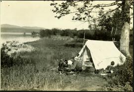
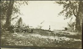
Geographic Features

Elements area

Taxonomy

Code

Scope note(s)

  • Includes both natural and artificial features
  • Physical landscape, built landscape
  • Urban and industrial landscapes
  • Topography
  • Site plans
  • Boundaries, districts, reserves, parks, sanctuaries, towns, etc.
  • NOTE: Mainly but not exclusively pertaining to photographic and cartographic records
  • SEE ALSO: Land, Settlement and Immigration

Source note(s)

  • MemoryBC Subject Groups

Display note(s)

    Hierarchical terms

    Geographic Features

      Equivalent terms

      Geographic Features

        Associated terms

        Geographic Features

          4134 Archival description results for Geographic Features

          4134 results directly related Exclude narrower terms
          Camp on Ton A Qua summit
          2014.10.1.070 · Item · 1909
          Part of Arthur Holland Land Surveying Collection
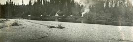
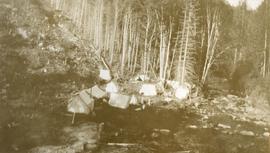
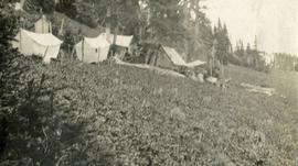
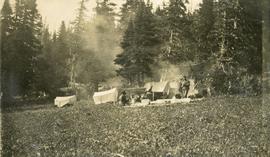
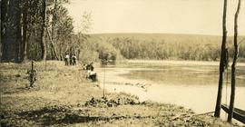
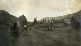
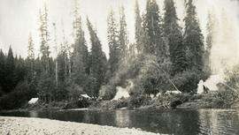
          Photograph depicts a cluster of tents on the edge of a meadow. Four or more people stand or sit amongst the tents. Smoke rises from a wood fire and drifts amongst the stub alpine trees in the background.

          2011.3.2.20 · Item · [ca. 1910-1924]
          Part of North Coast & Central BC Postcard Collection

          Street view photograph of a commercial section in downtown Prince George with several "Campbell's" delivery carts parked along the road. Visible establishments include "Campbell's All Cash Store" and "Club Cafe." Handwritten annotation in blue ballpoint pen on recto reads: "Howdy from Prince George! Going easy with all these kids- good to see Kathee. Snow here. Have fun at the sports show & don't over do it. Thinking of you guys, love Judy and Vic. P.S. Can't wait to go home to somewhere peaceful and quiet. 2-27-83." Postcard is addressed to: "Mr. & Mrs. Hauffer 8429-221 PL. Sn. Edmonds, WA. U.S. 98020." Verso is affixed with four Canadian 8-cent stamps.

          Campfire Company
          2012.13.1.46.37 · Item · 1980
          Part of J. Kent Sedgwick fonds

          Image depicts Kent Sedgwick (the man with a pipe in green) and an unknown individual sitting around a campfire somewhere in South Tweedsmuir Provincial Park.

          Camping at Stuart Lake, BC
          2004.6.17 · Item · [between 1920 and 1940]
          Part of Stuart Lake Photograph Collection

          Typed annotation on recto: "Camping at Stuart Lake - B.C." Two men and one woman kneeling among miscellaneous equipment on ground in front of small tent on the lake side. Large tree and bushes behind tent, hills in distance.

          Campsite
          2012.13.1.73.11 · Item · Aug. 1979
          Part of J. Kent Sedgwick fonds

          Image depicts a man at a campsite somewhere near Murray Ridge.

          Campsite
          2012.13.1.84.34 · Item · 1994
          Part of J. Kent Sedgwick fonds

          Image depicts Sue Sedgwick seated in a lawn chair near a campfire and several other unidentified individuals, as well as three dogs. The location is uncertain.

          2012.13.2.02.34 · File · 1996-1998
          Part of J. Kent Sedgwick fonds

          File consists of notes and reproductions relating to Brett & Hall landscape architecture and urban planning in Canada. File predominantly consists of photocopies of articles relating to urban planning, including "The Influence of Thomas Adams and the British New Towns Movement in the Planning of Canadian Resource Communities" by Oiva Saarinen; "Thomas Adams and the Commission of Conservation" by Alan H. Armstrong; "The Laying Out of Towns" by W.H. Dorsey; "The Relation of the City Engineer to Public Parks" by John C. Olmsted; "The Planning of Company Communities in the Lake Superior Mining Region" by Arnold R. Alanen; and "Planning the Canadian Environment" by L.O. Gertler.

          Canoe at Summit Lake
          2005.3.23 · Item · [ca. 1945]
          Part of John Hart Highway Photograph Collection

          Handwritten caption beside this photo reads: "I built this boat." Photograph depicts canoe and paddles afloat in water, grassy shore in foreground. A pair of pants can be seen in boat, as well as wood planks, box, and rope on shore.

          2009.5.3.64 · Item · [ca. 1913]
          Part of Taylor-Baxter Family Photograph Collection

          Photograph depicts a small pass through an island or peninsula on the Fraser River. Photo is believed to have been taken near Stone Creek, south of South Fort George. Annotation on verso of photograph reads: "FORT GEORGE CANYON. CANOE PASS. J. HEAY. PHOTO."

          2009.7.1.161 · Item · [ca. 1880 - ca. 1915]
          Part of Archdeacon W. H. Collison fonds

          Canoes sit on shore in foreground beside village buildings. A dock is visible above water in background.

          Handwritten annotation on verso reads: "Alert Bay Indian Ranch No. 14 Alert Bay. To be shown on page 69 or 70, re Alert Bay Mission."

          Canyon Ridge
          2012.13.1.15.29 · Item · [1975?]
          Part of J. Kent Sedgwick fonds

          Image depicts a view of the ridge above the Fraser River which forms the Grand Canyon, B.C.

          Cariboo Road
          2012.13.1.6.031 · Item · June 1974
          Part of J. Kent Sedgwick fonds

          Image depicts the Cariboo Road at Hat Creek Ranch, near Highway 99 on the way to Lillooet.

          2009.5.2.31 · Item · [ca. 1900]
          Part of Taylor-Baxter Family Photograph Collection

          Handwritten annotation on verso of photograph: "Early Days on the Cariboo Road. No. 8." Photograph depicts man driving two covered wagons pulled by team of six horses on gravel road. Valley crosses midground, hills in background. Handwritten annotation on recto of photograph: "H. F. Glassey Esq. P.O Box 950 Prince Rupert B.C. Dear Bert: We have been kept very busy have been on committee work all through the convention but it was wonderful will write you a long letter from Vancouver. Mrs Earley wants me to stay until Monday morning train. Met Mr. [Colley?] everything going fine here. I am sure you are busy [...?] Love from Sadie. Mr & Mrs. [Graif?] are living here."