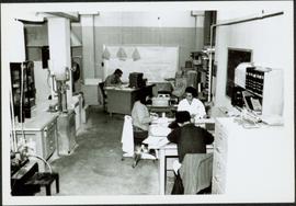
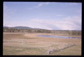
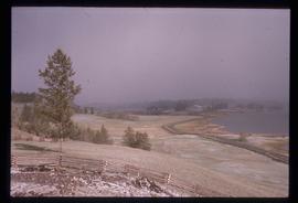
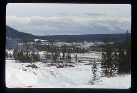
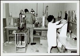
Environment

Elements area

Taxonomy

Code

Scope note(s)

  • Includes: environmental issues; nature, wilderness and scenery; climate and weather; environmentalists; environmental organizations and businesses; parks and natural areas; wildlife management; habitat and species protection/recovery; conservation activities.

Source note(s)

  • MemoryBC Subject Groups

Display note(s)

    Hierarchical terms

    Environment

      Equivalent terms

      Environment

        Associated terms

        Environment

          4534 Archival description results for Environment

          4534 results directly related Exclude narrower terms
          2000.1.1.3.19.034 · Item · 1965
          Part of Cassiar Asbestos Corporation Ltd. fonds

          Photograph depicts Ross Duddy with back to photographer, working at table in lab. Unidentified woman stands in right foreground operating unidentified machinery. Miscellaneous equipment and supplies throughout. Handwritten annotation on recto of photograph: "ROSS DUDDY / LAB SUPER".

          1965 - Mine Crew
          2000.1.1.3.19.072 · Item · 1965
          Part of Cassiar Asbestos Corporation Ltd. fonds

          Photograph depicts group of ten men standing and kneeling in unknown location at the Cassiar mine. Handwritten annotation on recto of photograph: "APPROX 1965 / BACK L-R / 1.- / 2. Don Erwin [i.e Irwin] / 3. MAC MAcCLOUD DIED 1979 / 4. JIM MURDOCK MINE SUPER / 5. RUPERT McKENZIE CAPT / 6. DANNY DEMETRI / 7. VIC SARAKOSKI / FRONT. L-R / 1. DON HUDGEON / 2. MIKE CLARK / 3. - [Adrian VanHill Sr.]". Information in above annotation supplemented with insight from individuals who contributed to Northern BC Archives Facebook Photo ID Project, contact archivist for more information in research file pertaining to this photograph.

          2000.1.1.3.19.033 · Item · 1965
          Part of Cassiar Asbestos Corporation Ltd. fonds

          Photograph depicts man [possibly Paul Clark?] seated with two women at table in lab. Second man [possibly Lab Superintendent Ross Duddy?] seated at table in background. Miscellaneous equipment and supplies throughout. Handwritten annotation on recto of photograph: "Paul Clark / [Odett?] Cario".

          1961 - Tramline & Plantsite
          2000.1.1.3.19.015 · Item · 1961
          Part of Cassiar Asbestos Corporation Ltd. fonds

          Photograph depicts tower and bucket tram in left foreground, plantsite in midground, mountains across valley in background. Dry rock storage building, mill, tailings pile, and many other buildings visible in plantsite. Handwritten annotation on verso of photograph: "1961".

          1961 - Shovel on Peak
          2000.1.1.3.19.012 · Item · 1961
          Part of Cassiar Asbestos Corporation Ltd. fonds

          Photograph depicts a crawler cable shovel on right, and bulldozer partially visible on left. Rock face of mountainside in background. Handwritten annotation on verso of photograph: "1961", on recto: "Mining 80 D shovel on [?] 64/70 to 6560 saddle on peak."

          1961 - Mine Garage
          2000.1.1.3.19.004 · Item · 1961
          Part of Cassiar Asbestos Corporation Ltd. fonds

          Photograph depicts a car and two dump trucks near a small garage by road in mine. One man stands at garage site among tires and miscellaneous tools. Blasthole drills, shovels, and dump trucks visible in distance. Rocks in foreground, mountains in background. Handwritten annotation on verso of photograph: "1961".

          1961 - Mine Buildings
          2000.1.1.3.19.003 · Item · 1961
          Part of Cassiar Asbestos Corporation Ltd. fonds

          Photograph depicts buildings at various locations in mine: crushing plant (centre?) and what is believed to be the original tramline loading station on left. Mine road featured in center, blasthole drill visible near dump truck in midground. Mine valley in background. Photo believed to have been taken from mine's South Peak. Handwritten annotation on verso of photograph: "1961".

          1961 - Explosive Preparation
          2000.1.1.3.19.009 · Item · 1961
          Part of Cassiar Asbestos Corporation Ltd. fonds

          Photograph depicts a man wearing a hard hat preparing long narrow bags of explosive material. Large bags of ammonium nitrate in right foreground, mountains in background. Handwritten annotation on verso of photograph: "1961".

          1961 - Explosive Preparation
          2000.1.1.3.19.010 · Item · 1961
          Part of Cassiar Asbestos Corporation Ltd. fonds

          Photograph depicts a man wearing a hard hat preparing long narrow bags of explosive material. Large bags of ammonium nitrate in right foreground, mountains in background. Handwritten annotation on verso of photograph: "1961".

          1961 - Explosive Preparation
          2000.1.1.3.19.008 · Item · 1961
          Part of Cassiar Asbestos Corporation Ltd. fonds

          Photograph depicts a man wearing a hard hat preparing explosive material, mountains in background. Dog stands near edge in midground, large bags of Ammonium Nitrate in right foreground. Handwritten annotation on verso of photograph: "1961".

          2000.1.1.3.19.005 · Item · 1961
          Part of Cassiar Asbestos Corporation Ltd. fonds

          Photograph depicts men standing near two Atlas Copco Drillmasters (blasthole drills). These are precision hammer drills which had their own power source. Large bags of ammonium nitrate in foreground, mountaintops in background. The men depicted here were likely members of the explosive crew. It is believed that this photo was taken on the North ridge, near the cirque dump. Handwritten annotation on verso of photograph: "1961".

          2000.1.1.3.19.006 · Item · 1961
          Part of Cassiar Asbestos Corporation Ltd. fonds

          Photograph depicts men standing near two Atlas Copco Drillmasters (blasthole drills). These are precision hammer drills which had their own power source. Large bags of ammonium nitrate in foreground, mountainside in background. The men depicted here were likely members of the explosive crew. It is believed that this photo was taken on the North ridge, near the cirque dump. Handwritten annotation on verso of photograph: "1961".

          2000.1.1.3.19.007 · Item · 1961
          Part of Cassiar Asbestos Corporation Ltd. fonds

          Photograph depicts an Atlas Copco Drillmaster (blasthole drill) near the mine road, mountainside in background. This is a precision hammer drill which had its own power source. It is believed that this photo was taken on the North ridge, near the cirque dump. Handwritten annotation on verso of photograph: "1961".

          2000.1.1.3.19.001 · Item · July 1961
          Part of Cassiar Asbestos Corporation Ltd. fonds

          Photograph depicts mine area at Cassiar, crushing plant visible on left. Various mine buildings visible midground. Blasthole drills, shovels, dozers, and dump trucks can be seen on bench in foreground at 6430 elevation. Handwritten annotations on recto of photograph: "6"; "View looking NW from top of S. peak 6790 elev. on 6430 stripping bench on it and 6050 ore bench further down on left."; "July 1961".

          1961 - 6430 Ore Bench
          2000.1.1.3.19.002 · Item · July 1961
          Part of Cassiar Asbestos Corporation Ltd. fonds

          Photograph depicts bench at 6430 elevation. Blasthole drills, shovels, dozers, and dump trucks can be seen on bench in midground. Mine valley in background. Handwritten annotation on verso of photograph: "1961".

          2019.10.7 · File · 10 Sept. 1969
          Part of Lockwood Survey Corporation Ltd. collection

          These remote-sensing aerial photographs were taken by Lockwood Survey Corporation Ltd. under contract for the B.C. Forest Service. Some photographs are annotated to show logging activity; clearcuts, slash piles, log booms, and tree debris on the water are also visible in some of the images. No detailed location information or index accompanies the photographs. These historically important aerial photographs depict Williston Lake soon after its creation in 1968 with the building of the W.A.C. Bennett Dam on the Peace River. Also depicted are the rivers and tributaries that empty into the Williston Reservoir, such as the Finlay River, the Ospika River, and the Omineca River.

          The identification coding on these photographs can be interpreted as follows:

          • The largest number on the leftmost side is the frame number for the individual photograph.
          • The following code to the right in the format "B) 69-53" is currently unknown, but may refer to an internal project number for the Lockwood Survey Corporation.
          • The 6" may refer to the camera's focal length in inches.
          • Next is "17,150 ASL" which is 17,150 feet Above Sea Level.
          • Following is "152.52" which refers to the camera's focal length in millimeters, which equals 6 inches.
          • The "W1308" may refer to the reel, but that is unconfirmed.
          • "10 SEP 69" is the date the photos were taken.
          2019.10.9 · File · 1 Aug. 1970
          Part of Lockwood Survey Corporation Ltd. collection

          These remote-sensing aerial photographs were taken by Lockwood Survey Corporation Ltd. under contract for the B.C. Forest Service. Some photographs are annotated to show logging activity; clearcuts, slash piles, log booms, and tree debris on the water are also visible in some of the images. No detailed location information or index accompanies the photographs. These historically important aerial photographs depict Williston Lake soon after its creation in 1968 with the building of the W.A.C. Bennett Dam on the Peace River. Also depicted are the rivers and tributaries that empty into the Williston Reservoir, such as the Finlay River, the Ospika River, and the Omineca River.

          The identification coding on these photographs can be interpreted as follows:

          • The largest number on the leftmost side is the frame number for the individual photograph.
          • The following code to the right in the format "B) 70-38" is currently unknown, but may refer to an internal project number for the Lockwood Survey Corporation.
          • The 6" may refer to the camera's focal length in inches.
          • Next is "17,150 ASL" which is 17,150 feet Above Sea Level.
          • Following is "152.63" which refers to the camera's focal length in millimeters, which equals 6 inches.
          • The "W1339" may refer to the reel, but that is unconfirmed.
          • "1 AUG 70" is the date the photos were taken.
          2019.10.8 · File · 1 Aug. 1970
          Part of Lockwood Survey Corporation Ltd. collection

          These remote-sensing aerial photographs were taken by Lockwood Survey Corporation Ltd. under contract for the B.C. Forest Service. Some photographs are annotated to show logging activity; clearcuts, slash piles, log booms, and tree debris on the water are also visible in some of the images. No detailed location information or index accompanies the photographs. These historically important aerial photographs depict Williston Lake soon after its creation in 1968 with the building of the W.A.C. Bennett Dam on the Peace River. Also depicted are the rivers and tributaries that empty into the Williston Reservoir, such as the Finlay River, the Ospika River, and the Omineca River.

          The identification coding on these photographs can be interpreted as follows:

          • The largest number on the leftmost side is the frame number for the individual photograph.
          • The following code to the right in the format "B) 70-38" is currently unknown, but may refer to an internal project number for the Lockwood Survey Corporation.
          • The 6" may refer to the camera's focal length in inches.
          • Next is "17,150 ASL" which is 17,150 feet Above Sea Level.
          • Following is "152.63" which refers to the camera's focal length in millimeters, which equals 6 inches.
          • The "W1339" may refer to the reel, but that is unconfirmed.
          • "1 AUG 70" is the date the photos were taken.