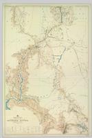
Pope, Frank L. “Sketch Map Showing the Proposed Route of the Western Union Telegraph Between Fort Frazer and the Stekine River, British Columbia. From exploration by the party under the command of Maj. Frank L. Pope Ass’t Engineer, 1866.
Stikine River, BC
3 Archival description results for Stikine River, BC
    3 results directly related            
      
      Exclude narrower terms    


                                2012.11.2.6
                      
                                     · 
                        
              Item            
                      
                                                                 · 
                            
                1866              


            Part of             Northern BC Archival Replica Access Collection           
              
                                2008.2.019
                      
                                     · 
                        
              Item            
                      
                                                                 · 
                            
                1935              


            Part of             NBCA Maps and Plans Collection           
              Colour-coded geological topographic map. Geological Survey produced for the Bureau of Economic Geology, Department of Mines, Bureau of Economic Geology, Canada. Scale 1:126,720. Includes overview of "General Geology" and "Economic Geology."
                                2008.2.016
                      
                                     · 
                        
              Item            
                      
                                                                 · 
                            
                1 June 1929              


            Part of             NBCA Maps and Plans Collection           
              Topographic map depicting regions, communities, government posts. bodies of water, transport routes, surveyed areas, and reserves.