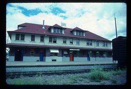
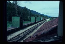
Mostrar 352 resultados

Archival description
CN Train Yard
2012.13.1.3.121 · Item · 12 Oct. 1989
Parte de J. Kent Sedgwick fonds

Image depicts a number of trains in the CNR train yard taken from River Road in Prince George, B.C. Map coordinates 53°54'51.5"N 122°43'29.6"W

Highway 97
2012.13.1.3.164 · Item · May 2001
Parte de J. Kent Sedgwick fonds

Image depicts a section of Highway 97 looking south. Map coordinates 53°55'10.3"N 122°46'54.9"W

Cariboo Road
2012.13.1.6.031 · Item · June 1974
Parte de J. Kent Sedgwick fonds

Image depicts the Cariboo Road at Hat Creek Ranch, near Highway 99 on the way to Lillooet.

Campers
2012.13.1.45.04 · Item · 1983
Parte de J. Kent Sedgwick fonds

Image depicts numerous campers and other vehicles in Tumbler Ridge, B.C.

Strathnaver - BCR
2012.13.1.50.023 · Item · 1975
Parte de J. Kent Sedgwick fonds

Image depicts the BCR, as well as the Dunkley Lumber Mill, in Strathnaver, B.C.

Paddlewheel Park
2012.13.1.7.201 · Item · Nov. 2000
Parte de J. Kent Sedgwick fonds

Image depicts the Fraser River at Paddlewheel park, with a train on the other side of the river, in Prince George B.C.

Trains and People
2012.13.1.19.07 · Item · 1979
Parte de J. Kent Sedgwick fonds

Image depicts a train and a group of unknown individuals at the GTP roundhouse in Prince George, B.C.

GTP Roundhouse
2012.13.1.19.08 · Item · 1979
Parte de J. Kent Sedgwick fonds

Image depicts the Grand Trunk Pacific railway roundhouse in Prince George, B.C.

A House
2012.13.1.22.18 · Item · 1970
Parte de J. Kent Sedgwick fonds

Image depicts a house in Island Cache. There are several cars parked outside it.

Rail Road Tunnel
2012.13.1.29.15 · Item · 1991
Parte de J. Kent Sedgwick fonds

Image depicts a woman standing inside a tunnel from the old Kettle Valley Rail Road.

Atlin Road?
2012.13.1.98.43 · Item · 1999
Parte de J. Kent Sedgwick fonds

Image depicts what is possibly Atlin Road. Numerous mountains are visible in the distance.

Miles Canyon - the Schwatka
2012.13.1.98.61 · Item · 1999
Parte de J. Kent Sedgwick fonds

Image depicts numerous unidentified individuals getting off a boat which bears the name "Schwatka." It is located somewhere in Miles Canyon.

Highway and Mountains
2012.13.1.98.68 · Item · 1999
Parte de J. Kent Sedgwick fonds

Image depicts a van on a highway with mountains in the distance; the location is uncertain, though it is possibly along the Alaska Highway.

Highway and Mountains
2012.13.1.98.70 · Item · 1999
Parte de J. Kent Sedgwick fonds

Image depicts a van on a highway with mountains in the distance; the location is uncertain, though it is possibly along the Alaska Highway.

Old Trestle
2012.13.1.100.17 · Item · 1999
Parte de J. Kent Sedgwick fonds

Image depicts an old trestle along the White Pass railway.

Old Trestle
2012.13.1.100.18 · Item · 1999
Parte de J. Kent Sedgwick fonds

Image depicts an old trestle along the White Pass railway.

Old Trestle
2012.13.1.100.22 · Item · 1999
Parte de J. Kent Sedgwick fonds

Image depicts an old trestle along the White Pass railway, and the White pass Train on the left of the image.

Skidder - Tree Trim Delimber
2012.13.1.122.27 · Item · May 1980
Parte de J. Kent Sedgwick fonds

Image depicts two unidentified individuals examining a tractor meant to delimb trees. It is located in Prince George, B.C.

Heavy Machinery with Logs
2012.13.1.122.31 · Item · May 1980
Parte de J. Kent Sedgwick fonds

Image depicts a piece of heavy machinery lifting numerous logs. It is likely located in Prince George, B.C.

Crestbrook Forest Industries Operations
2012.13.1.122.34 · Item · July 1982
Parte de J. Kent Sedgwick fonds

Image depicts a man attaching a logging trailer to a crane on a wooden structure to stack the trailer on the truck. A Crestbrook Forest Industries sawmill is located in the background.

Hansard Railroad Bridge
2012.13.1.87.003 · Item · [between 1975 and 1995]
Parte de J. Kent Sedgwick fonds

Image depicts the Hansard railroad bridge looking west. Map coordinates 54°04'37.9"N 121°50'46.3"W

Railway Tracks and Old Houses
2012.13.1.87.009 · Item · [between 1975 and 1995]
Parte de J. Kent Sedgwick fonds

Image depicts railway tracks on the right side of the image, and several old houses alongside it. The location is uncertain.

Dirt Road
2012.13.1.87.024 · Item · [between 1975 and 1995]
Parte de J. Kent Sedgwick fonds

Image depicts a dirt road leading through numerous trees toward a mountain. The location is uncertain, likely on the way to Longworth, B.C.

Dirt Road
2012.13.1.87.025 · Item · [between 1975 and 1995]
Parte de J. Kent Sedgwick fonds

Image depicts a dirt road leading through numerous trees toward a mountain. The location is uncertain, likely on the way to Longworth, B.C.

Longworth - Railway Tracks
2012.13.1.87.031 · Item · [between 1975 and 1995]
Parte de J. Kent Sedgwick fonds

Image depicts two unidentified individuals standing next to the train station, and two railway tracks running through Longworth, B.C.

House in Upper Fraser, BC
2012.13.1.87.042 · Item · [between 1975 and 1995]
Parte de J. Kent Sedgwick fonds

Image depicts and old house and vehicle in Upper Fraser, B.C. Map coordinates 54°07'05.7"N 121°56'38.9"W

Upper Fraser Mill
2012.13.1.87.061 · Item · [between 1975 and 1995]
Parte de J. Kent Sedgwick fonds

Image depicts the entrance to the Upper Fraser mill yard in Upper Fraser, B.C. Map coordinates 54°07'10.8"N 121°56'51.7"W