2023.2.2.14
·
Subseries
·
2022-2024
Part of Dr. Paul Sanborn fonds
2074 results with digital objects
Show results with digital objects
2023.2.2
·
Series
·
1960-2024
Part of Dr. Paul Sanborn fonds
Series consists of records created and collected in relation to research projects Dr. Paul Sanborn was engaged in, often with other colleagues, during his employment with the BC Ministry of Forests and/or the University of Northern British Columbia. These archival research records are predominantly unpublished documents, reports, data, and photographs. Some of Sanborn's research projects did not result in a formal scientific publication. In other instances, some of Sanborn's research projects resulted in only a portion of the collected data utilized for a formal publication.
Sanborn compiled details about each research project and its associated records in a summary note. Each of these notes is provided in PDF format along with its research project series. These notes serve as an essential guide for researchers who wish to interpret, utilize, and repurpose Sanborn's data for other future research projects.
2023.2
·
Fonds
·
1960-2024
Fonds consists of the research records of Dr. Paul Sanborn, a University of Northern British Columbia faculty member in the Department of Ecosystem Science and Management.
Sanborn, Paul Thomas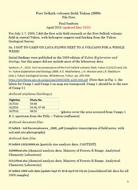
2023.2.2.7
·
Subseries
·
2009-2010, 2023
Part of Dr. Paul Sanborn fonds
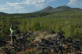
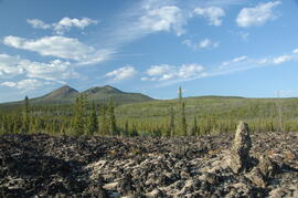
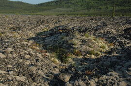
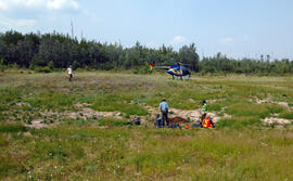
For July 1-7, 2009, Dr. Paul Sanborn did the first soils field research at the Fort Selkirk volcanic field in central Yukon, with helicopter support and funding from the Yukon Geological Survey.
Initial findings were published in the 2009 edition of Yukon Exploration and Geology, but this paper did not include most of the laboratory data:
Sanborn, P., 2010. Soil reconnaissance of the Fort Selkirk volcanic field, Yukon (115I/13 and 14). In: Yukon Exploration and Geology 2009, K.E. MacFarlane, L.H. Weston and L.R. Blackburn (eds.), Yukon Geological Survey, Whitehorse, Yukon. pp. 293-304. https://emrlibrary.gov.yk.ca/ygs/yeg/2009/2009_p293-304.pdf [Note that in Fig. 1, the labels for Camp 1 and Camp 2 on map are transposed; Camp 1 should be to the east of Camp 2.]

2023.2.2.5
·
Subseries
·
1991-2023, predominant 2004
Part of Dr. Paul Sanborn fonds
The Lost Chicken Mine, a placer gold mine in eastern Alaska, approximately 120 km west of Dawson City, Yukon, is an important fossil locality for the late Pliocene (approximately 2.5 – 3.0 million years ago). A comprehensive account of the stratigraphy and paleontology of this site was given by:
Matthews, J.V., Jr., J.A. Westgate, L. Ovenden, L.D. Carter, and T. Fouch. 2003. Stratigraphy, fossils, and age of sediments at the upper pit of the Lost Chicken gold mine: new information on the late Pliocene environment of east central Alaska. Quaternary Research 60: 9-18. https://doi.org/10.1016/S0033-5894(03)00087-5
Dr. Paul Sanborn visited the site on July 20, 2004, as part of a group led by Duane Froese (Professor, University of Alberta). The group concentrated on a single exposure (~ 2 m thick) straddling the Lost Chicken tephra, a volcanic ash bed (2.9 ± 0.4 myr) which is a major stratigraphic marker at the site. Sanborn described, photographed, and sampled this exposure, and obtained a basic set of characterization data. Intact samples were collected but thin sections were never produced.
2016.5.2
·
Series
·
1911-2019
Part of Harry Coates fonds
Series consists of materials reflecting Harry Coates life-long dedication and activism for sustainable forest management. Series also reflects Harry Coates' interest in forest history; series includes old forest industry records collected by Harry Coates including a timber sales ledger and timber license.
2016.5.2.15
·
File
·
[after 2010]
Part of Harry Coates fonds
File consists of notes, charts, and photographs showing forest management. May have been for a presentation by Harry Coates.
2016.5.1
·
Series
·
1941-2018
Part of Harry Coates fonds
Series consists of records pertaining to Harry Coates work and training as a BC Forest Service Research Technician. Series includes documentation for various Sx trials and experimental plots (E.P.) Harry Coates worked on.
2014.6.1
·
Series
·
1953-2017
Part of Rustad & Dezell Family fonds
Series consists of records reflecting the activities of the Dezell and Rustad families. Series include mayoral records from Bea and Garvin Dezell when Garvin served as Mayor of Prince George. Series includes materials celebrating Bea Dezell's life created by her family. Series also includes fundraising efforts for the Northern Medical Programs Trust. Finally, series includes a collection of "spruce" dollars and commemorative coins.
2016.5
·
Fonds
·
1957-2014
Fonds consists of records Harry Coates created or received and retained during his career as a BC Forest Service Research Technician and into his retirement as a Sustainable Forest Management activist. Fonds includes materials from his work at the Aleza Lake Research Forest.
Coates, Harry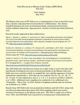
2023.2.2.8
·
Subseries
·
2003-2014
Part of Dr. Paul Sanborn fonds
The Kluane Lake area of SW Yukon was a continuing focus of Dr. Paul Sanborn's research for more than a decade, and generated several productive collaborations. Key themes included biological soil crusts in boreal grasslands, and interactions between aeolian sediment deposition, slope processes, and fire in boreal grassland and forest soils.
Research results appeared in these publications:
Marsh, J., Nouvet, S., Sanborn, P., and Coxson, D. 2006. Composition and function of biological soil crust communities along topographic gradients in grasslands of central interior British Columbia (Chilcotin) and southwestern Yukon (Kluane). Canadian Journal of Botany 84: 717-736. https://doi.org/10.1139/b06-026
Pautler, B.G., Reichart, G.-J., Sanborn, P.T., Simpson, M.J., and Weijers, J.W.H. 2014. Comparison of soil derived tetraether membrane lipid distributions and plant-wax δD compositions for reconstruction of Canadian Arctic temperatures. Palaeogeography, Palaeoclimatology, Palaeoecology 404: 78-88. https://doi.org/10.1016/j.palaeo.2014.03.038
Sanborn, P. and A.J.T. Jull. 2010. Loess, bioturbation, fire, and pedogenesis in a boreal forest – grassland mosaic, Yukon Territory, Canada. 19th World Congress of Soil Science, Soil Solutions for a Changing World 1 – 6 August 2010, Brisbane, Australia. http://www.iuss.org/19th%20WCSS/Symposium/pdf/0120.pdf
The 2003 field work with Darwyn Coxson was a pilot study to assess the types and distribution of biological soil crusts in boreal grasslands in the Kluane Lake area. Eight sites were visited at which the team sampled the crust and the uppermost A horizon immediately underneath it. Note that site numbers Y03-03, -04, -05, -06, -07, -09, -10 and -12 were indicated as sites 3, 4, 5, 6, 7, 9, 10 and 12 in Table 1 of Marsh et al. (2006). Additional crust sampling was conducted at two additional sites (“Peninsula”, “Silver City”) in 2004; details of sampling methods and site locations are in Marsh et al. (2006).
Results from 2009 field work were presented in Sanborn and Jull (2010), along with soil charcoal radiocarbon dates from 2003-2008 sampling which were used to reconstruct fire history in the Kluane Lake area. The 2003 (a single site at Silver City), 2004, and 2008 field work consisted of a reconnaissance of grassland and forest sites across a range of aspects and slope positions in order to recover buried soil charcoal.
2016.5.4
·
Series
·
[1958-2014]
Part of Harry Coates fonds
Series consists of forestry photographs. Series includes photographs taken at experimental plots.
2016.5.4.18
·
File
·
[1970-2014]
Part of Harry Coates fonds
File consists of photographs mostly depicting trees, forests, and logs. Some photos include Harry Coates. One set of photographs shows Harry Coates accepting an award.
2012.13.2.17.27
·
File
·
1986, 2004-2011
Part of J. Kent Sedgwick fonds
File consists of notes, clippings, and reproductions relating to Sinclair Mills, a community along the East Line. Includes material regarding the development of a sawmill in Sinclair Mills and life in the community. Includes "Interview with Louisa Mueller" typed transcript of an interview with Louisa Mueller regarding her life at Sinclair Mills (29 Oct. 1999). File also includes photographs depicting various Sinclair Mills buildings, including of the silo and bunkhouse (2009-2010).
2023.2.2.13
·
Subseries
·
2007-2010
Part of Dr. Paul Sanborn fonds
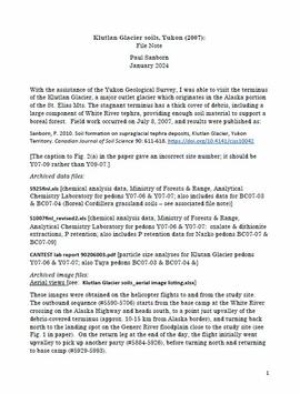
With the assistance of the Yukon Geological Survey, Dr. Paul Sanborn was able to visit the terminus of the Klutlan Glacier, a major outlet glacier which originates in the Alaska portion of the St. Elias Mountains. The stagnant terminus has a thick cover of debris, including a large component of White River tephra, providing enough soil material to support a boreal forest. Field work occurred on July 8, 2007, and results were published as:
Sanborn, P. 2010. Soil formation on supraglacial tephra deposits, Klutlan Glacier, Yukon Territory. Canadian Journal of Soil Science 90: 611-618. https://doi.org/10.4141/cjss10042
2012.13.2.19.02
·
File
·
1972, 1998-2010
Part of J. Kent Sedgwick fonds
File consists of notes, clippings, and reproductions relating to the gold rush in Quesnel and Likely, British Columbia. Includes: "Guide to the Goldfields: Cariboo Country" newspaper edition (1998); "Cariboo, Chilcotin Coast, Likely" brochure published by Likely & District Chamber of Commerce [199-]; "The UNBC Quesnel Rover Research Centre" pamphlet published by the University of Northern British Columbia (2002); "New Nugget Restaurant" paper placemat (1972); and "Likely" brochure from the Likely Chamber of Commerce [198-]. Also includes photographs depicting a camping trip in Likely, British Columbia (2010).
2023.2.2.6
·
Subseries
·
1983-2010
Part of Dr. Paul Sanborn fonds
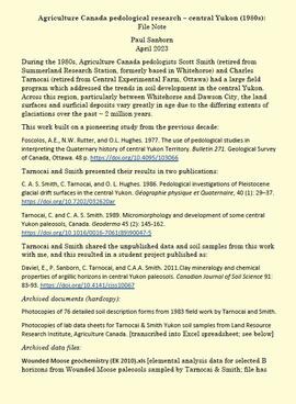
During the 1980s, Agriculture Canada pedologists Scott Smith (retired from Summerland Research Station, formerly based in Whitehorse) and Charles Tarnocai (retired from Central Experimental Farm, Ottawa) had a large field program which addressed the trends in soil development in the central Yukon. Across this region, particularly between Whitehorse and Dawson City, the land surfaces and surficial deposits vary greatly in age due to the differing extents of glaciations over the past ~2 million years.
This work built on a pioneering study from the previous decade:
Foscolos, A.E., N.W. Rutter, and O.L. Hughes. 1977. The use of pedological studies in interpreting the Quaternary history of central Yukon Territory. Bulletin 271. Geological Survey of Canada, Ottawa. 48 p. https://doi.org/10.4095/103066
Tarnocai and Smith presented their results in two publications:
C. A. S. Smith, C. Tarnocai, and O. L. Hughes. 1986. Pedological investigations of Pleistocene glacial drift surfaces in the central Yukon. Géographie physique et Quaternaire, 40 (1): 29–37. https://doi.org/10.7202/032620ar
Tarnocai, C. and C. A. S. Smith. 1989. Micromorphology and development of some central Yukon paleosols, Canada. Geoderma 45 (2): 145-162. https://doi.org/10.1016/0016-7061(89)90047-5
Tarnocai and Smith shared the unpublished data and soil samples from this work with Dr. Paul Sanborn, and this resulted in a student project published as:
Daviel, E., P. Sanborn, C. Tarnocai, and C.A.A. Smith. 2011.Clay mineralogy and chemical properties of argillic horizons in central Yukon paleosols. Canadian Journal of Soil Science 91: 83-93. https://doi.org/10.4141/cjss10067

2023.2.2.7.4.006
·
Item
·
2009
Part of Dr. Paul Sanborn fonds

2023.2.2.7.4.008
·
Item
·
2009
Part of Dr. Paul Sanborn fonds

2023.2.2.7.4.013
·
Item
·
2009
Part of Dr. Paul Sanborn fonds

2023.2.2.7.4.021
·
Item
·
2009
Part of Dr. Paul Sanborn fonds

2023.2.2.7.4.022
·
Item
·
2009
Part of Dr. Paul Sanborn fonds

2023.2.2.7.4.026
·
Item
·
2009
Part of Dr. Paul Sanborn fonds

2023.2.2.7.4.029
·
Item
·
2009
Part of Dr. Paul Sanborn fonds

2023.2.2.7.4.030
·
Item
·
2009
Part of Dr. Paul Sanborn fonds

2023.2.2.7.4.031
·
Item
·
2009
Part of Dr. Paul Sanborn fonds

2023.2.2.7.4.033
·
Item
·
2009
Part of Dr. Paul Sanborn fonds

2023.2.2.7.4.050
·
Item
·
2009
Part of Dr. Paul Sanborn fonds

2023.2.2.7.4.052
·
Item
·
2009
Part of Dr. Paul Sanborn fonds
2023.2.2.7.4.053
·
Item
·
2009
Part of Dr. Paul Sanborn fonds
2023.2.2.7.4.057
·
Item
·
2009
Part of Dr. Paul Sanborn fonds
2023.2.2.7.4.058
·
Item
·
2009
Part of Dr. Paul Sanborn fonds
2023.2.2.7.4.061
·
Item
·
2009
Part of Dr. Paul Sanborn fonds
2023.2.2.7.4.075
·
Item
·
2009
Part of Dr. Paul Sanborn fonds
2023.2.2.7.4.081
·
Item
·
2009
Part of Dr. Paul Sanborn fonds
2023.2.2.7.4.082
·
Item
·
2009
Part of Dr. Paul Sanborn fonds

2023.2.2.7.4.086
·
Item
·
2009
Part of Dr. Paul Sanborn fonds

2023.2.2.7.4.087
·
Item
·
2009
Part of Dr. Paul Sanborn fonds
2023.2.2.7.4.093
·
Item
·
2009
Part of Dr. Paul Sanborn fonds
2023.2.2.7.4.105
·
Item
·
2009
Part of Dr. Paul Sanborn fonds
2023.2.2.7.4.107
·
Item
·
2009
Part of Dr. Paul Sanborn fonds
2023.2.2.7.4.109
·
Item
·
2009
Part of Dr. Paul Sanborn fonds

2023.2.2.7.4.112
·
Item
·
2009
Part of Dr. Paul Sanborn fonds
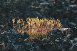
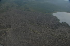
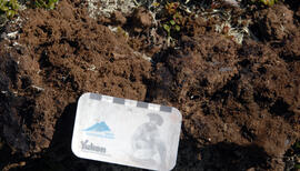
This image appears as Figure 8 in the publication:
Sanborn, P., 2010. Soil reconnaissance of the Fort Selkirk volcanic field, Yukon (115I/13 and 14).
In: Yukon Exploration and Geology 2009, K.E. MacFarlane, L.H. Weston and L.R. Blackburn
(eds.), Yukon Geological Survey, Whitehorse, Yukon. pp. 293-304. https://emrlibrary.gov.yk.ca/ygs/yeg/2009/2009_p293-304.pdf
2023.2.2.7.4.115
·
Item
·
2009
Part of Dr. Paul Sanborn fonds

2023.2.2.7.4.118
·
Item
·
2009
Part of Dr. Paul Sanborn fonds
2023.2.2.7.4.121
·
Item
·
2009
Part of Dr. Paul Sanborn fonds
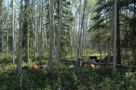
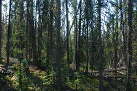
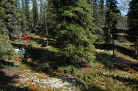
2023.2.2.8.20
·
File
·
2009
Part of Dr. Paul Sanborn fonds
2023.2.2.8.20.01
·
Item
·
2009
Part of Dr. Paul Sanborn fonds
Photograph depicts a Kluane Lake transect 1 location.
2023.2.2.8.20.03
·
Item
·
2009
Part of Dr. Paul Sanborn fonds
Photograph depicts a Kluane Lake transect 1 location.
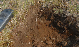
2023.2.2.8.20.07
·
Item
·
2009
Part of Dr. Paul Sanborn fonds
Photograph depicts a Kluane Lake transect 1 location.