Map depicts the Abbotsford area, including railway lines.
Map depicts proven on & offshore oil & gas areas, and probable oil & gas areas in less then 1000' water. The map conveys the North Pole in the centre and spans out to include Canada, Europe and the "Union of Soviet Socialist Republics."
Map depicts annotations of the freight-way routes throughout British Columbia. These routes include: the Garnet Enterprise Truck Haul from Vancouver to Terrace, the Canadian Freightways from Vancouver to Edmonton to Alaska; the Lindsay Transfer from Terrace to Dease Lake and Telegraph Creek; and the Northland Navigation roll-on and roll-off service.
Government map depicts railway lands, lands "disposed of", grazing leases, and timber berths. Shows the British Columbia 'railway belt' running from Greater Vancouver to Field, B.C.
Map depicts railways in British Columbia, with insets for the Lower Mainland and the Kootenays.
Map depicts the Coast of British Columbia and Federal and Provincial proposed fishing boundaries, including the 200 mile limit.
Map depicts Canadian railways in operation at 2011.
Map depicts the shipping highway routes across Canada. Primary, secondary, and access routes are noted as-well as proposed routes.
Map depicts the Canadian National Railway system, including trackage for the Central Vermont Railway, the Detroit & Toledo Shore Line Railroad, the Grand Trunk Western Railroad, the Duluth Winnipeg & Pacific Railway, and the Northern Alberta Railway.
Map depicts the CNR system in Canada and the United States and all of its connecting lines, including the Central Vermont Railway, the Grand Trunk Western Railroad, and the Duluth Winnipeg & Pacific Railway.
Map depicts passenger routes on the Canadian Pacific Railway and its connecting lines in 1925.
Maps within this series document the placer streams, islands and harbours of the Queen Charlotte Islands; as well as the mining properties located within the vicinity of Stewart, BC.
Fonds consists of textual, photographic, cartographic, electronic and promotional films/video recordings related to the mining operations of Cassiar Asbestos Mining Corporation (CAMC) and creation of Cassiar townsite. CAMC records primarily consist of records related to mining operations including construction, engineering, daily mining operations, administration of CAMC, tallies of extractions, labour and union activities, corporate events and visits by dignitaries. Townsite records are primarily visual representations of townsite construction, including the creation of health, education and community services including Cassiar's private hospital, school, library, as well as townsite images. Photographs include documentation of natural and man-made landscapes within the Cassiar region of Northern BC. Other holdings include a near complete run of Cassiar's community newspaper.
Cassiar Asbestos Corporation Ltd.Map depicts the city of Vancouver and its railways.
Real estate map depicts the areas around Coquitlam, Port Coquitlam, and Port Moody, including rail trackage.
Map depicts the Cowichan Lake area, including rail trackage for the Western Forest Industries Logging Railway, the Canadian National Railway, and the BC Forest Products Logging Railway.
Map depicts the Cowichan Lake area, including rail trackage for the Western Forest Industries Logging Railway, the Canadian National Railway, and the BC Forest Products Logging Railway.
The David Davies Railway Collection encompasses all facets of railway history specifically in the province of British Columbia and the Yukon territory. The collection consists of research material accumulated over the course of more than fifty years, and includes monographs, periodicals, articles, clippings, railway timetables, photographs, maps and plans, and excerpts. Material covers public, tourist, and private (industrial) railways, including: CPR, KVR, E&N; CNR, CNoR, GTPR; and PGER, BCR. The collection excludes material regarding streetcar systems and rapid transit, but includes long distance electric interurbans.
The map depicts the distribution locations and transportation routes for the processing of mineral and petroleum in British Columbia.
Map depicts historical rail lines in the BC lower mainland, including trackage for the BC Electric Railway, the Canadian Northern Pacific Railway, the Canadian Pacific Railway, the Great Northern Railway, and the Pacific Great Eastern Railway, among others.
Map depicts the city of Kelowna and area. Annotated by Davies to emphasize rail lines.
Map depicts area around Kelowna, with annotated Kettle Valley Railway Carmi subdivision line, Hydraulic Lake, and McCulloch.
Map depicts locations of all mining properties in British Columbia. Includes index with names of owners of properties.
Map depicts producing mines and prospects in British Columbia and parts of Alberta.
Map depicts the whole of Canada and notes: gas pipelines, gas gathering lines, proposed gas pipelines, oil pipelines, oil gathering lines, proposed oil pipelines, gas fields, oil fields, refining centres, extraction plants, and oil sands. There is a smaller subsequent map of Alberta highlighting these features in greater detail.
Map depicts rail lines in the BC lower mainland, including BC Hydro Railway, Burlington Northern Railway, the Canadian Pacific Railway, the Canadian National Railway, and the Pacific Great Eastern Railway.
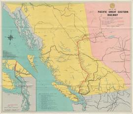
Map depicts the routes of the Pacific Great Eastern Railway, showing stations, railway connection, and the PGE Microwave Communication System.
The map depicts mineral deposits in Northern British Columbia.
The map depicts where minerals can be found and also includes railways, highways, and roadways for easy access to desired minerals.
This file consists of 10 photographs pertaining to the Hixon Creek Cariboo Gold Company, and the Quesnel Quartz Mine; as well as two sheets of letterhead from the "Hixon Gold Recovery Ltd." a handwritten speech re: a mineral claim, and a hand drawn map and overlay pertaining to the Wellington and Highland (Belle or Lass) mineral claims.
Map depicts existing oil lines, oil lines proposed or under construction, product lines, existing gas lines, gas lines proposed or under construction, LPG lines, and LPG lines proposed in Canada and Northern USA.
Series consists of large format maps and plans relating to railways in British Columbia and Canada. Also includes oversize documents.
Map depicts the Shuswap Lakes, Rogers Pass, Kamloops, Yellowhead Pass, Thompson Valley, and the Nicola Valley. Also includes the first clues to a treasure hunt.
Map depicts the growth of Vancouver's street car system as from the laying of the first tracks in 1889 to the last section laid (Clark Dr., Hastings to Venables).
The Prince George Railway & Forestry Museum Society Collection consists primarily of textual, photographic, and cartographic records related to the regional developments of the railway industry in Northern BC. A predominant portion of the collection is made up of material from the Canadian National Railway; other railways represented include the Pacific Great Eastern Railway, the British Columbia Railway (BC Rail), the Grand Trunk Pacific Railway, the Grand Trunk Railway, the Intercolonial Railway, and the Okanagan Express. Significant geographical areas covered include Prince George, the Peace River Region, Terrace, Bulkley Valley, Hazelton and Prince Rupert.
The forestry industry is represented in the collection with operational and financial records from Fyfe Lake Sawmill Ltd., which operated southwest of Prince George in the 1950s.
The collection has been organized into series according to creator, each of which also has been arranged to subseries, file and item level, where applicable. This collection consists of eight series, as follows:
1) Canadian National Railway
2) Grand Trunk Railway
3) Pacific Great Eastern Railway
4) British Columbia Railway (BC Rail)
5) Canadian Pacific Railway (CPR)
6) Intercolonial Railway
7) Fyfe Lake Sawmill ltd.
8) PGRFM
9) Photographs
Map depicts rail trackage in the Greater Vancouver area, showing dates of completion and abandonment of railway lines. Also shows proposed rail lines.
Map depicts railway lines in the state of Washington, including those crossing over the border into British Columbia.
Map depicts all current rail lines in Western Canada and Alaska and major railway stations. Includes insets for Alaska & Yukon, Edmonton area, Winnipeg area, and the Vancouver area.
Hand drawn draft map depicts historical railway routes in British Columbia. Includes dates and annotated information about rail lines.
Map depicts the regional district of Kitmat, but is extensively annotated showing the proposed route of the Kitmat Truck Ferry, running through Terrace and up into the "Yukon Markets," and the Kispiox Connector, running from Prince Rupert to Hazelton and further East along Highway 16 and north along the Kispiox River.
Map depicts south eastern British Columbia, with highlighted annotations by Davies to emphasize location of rail lines.
Map depicts the City of Squamish, Howe Sound, and the Britannia Mine.
Map depicts existing harbour development in Stewart, with an enlargement of the west side of the harbour.
Map depicts the cities of Summerland, Penticton, and Naramata. Annotated by Davies to emphasize the rail lines in the area.
Map depicts the cities of Summerland, Penticton, and Naramata. Annotated by Davies to emphasize the rail lines in the area.
Map depicts proposed industrial area outside of Terrace, British Columbia.
Map depicts location of treasure hidden between Clearwater and Clemina, BC.
Tourist map of Prince George depicts city area, including railway trackage.
Map depicts the province of British Columbia. Includes rail lines and historical notes about the province.
Tourist map of Prince George depicts city area, with annotations by Davies to emphasize locations of rail lines.

