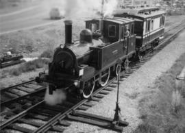
The Canadian National Railway series consists of administrative records, safety records, correspondence between departments, labour records, records pertaining to train movements, maintenance records, and ephemera. Includes publications concerning the topics of unionized labour, railway operation, maintenance of way, handling of hazardous materials, safety, public interest, and the two Royal Tours of 1939 and 1959. Also consists of maps and technical drawings depicting Canadian National Rail lines and equipment.
Canadian National RailwayFile contains information, including diagrams, measurement charts, and a map, for experimental plot 103.
File contains information, including diagrams, measurement charts, and a map, for experimental plot 106.
File contains information, including diagrams, measurement charts, and a map, for experimental plot 107.
Map of Timber Sale X9696 shows the area for the TSX with the location of plots, roads, traverse posts, and the Forest Branch cabin. Location is 4 miles from the Myra Station of the Kettle Valley Railway.
Map of Timber Sale X9696 shows topography for the area. Location is 4 miles from the Myra Station of the Kettle Valley Railway.
File contains datelines, small maps consisting of ecological site types, handwritten notes, overheads, terrain resource management information digital map data, and trail system maps.
Map reflects lot and STL lines, timber sale boundaries, Highway 16, roads, beetle infested areas, and plots X91971 to X91980, and X89946.
Map reflects boundaries for the Aleza Lake Experiment Station, permanent sample plots, timber sales locations, and the Ecological Reserve.
Map reflects highways, main, branch and property roads, trails, public sustained yield unit boundaries, cutting permit boundary, contours, height of land, edge of lake, merchantable and immature timber, non-commercial cover, and swamps.
Map reflects forest type boundary line, bogs and swampy non-forested areas, creeks, lakes, rivers, tree species labels of spruce, balsam, and birch, stand descriptions, historical timber sale boundaries, stand history symbol, gravelled secondary roads, unimproved old roads, management compartment boundary, research forest boundary, ecological reserve boundary, and old growth emphasis areas.
Map commissioned from Ministry of Forests Prince George Region from Madrone Consultants shows Aleza Lake Research Forest Management Compartments and Administrative Boundaries. Map is 1 of 6. Map shows the Aleza Lake Ecological Reserve, Natural Forest Reserve, the Special Management Area, and Riparian Management Research Area.
Map commissioned from Ministry of Forests Prince George Region from Madrone Consultants shows Aleza Lake Research Forest Research Trials and Permanent Plots. Map is 2 of 6. Map shows permanent plot locations, historical timber sales areas, demonstration areas, and research plots.
Map commissioned from Ministry of Forests Prince George Region from Madrone Consultants shows Aleza Lake Research Forest terrain themes. Map is 6 of 6. Map shows the following types of terrain units: typic, slope, percipitous, gullied, hummocky, rocky, alluvial, and organic. Ecosystem classification and mapping by Oikos Ecological Services Ltd.
Map reflects reserve boundary, roads, trails, 20 feet contour intervals, air photo centre, declination, swamps, and mile post at the Aleza Lake Experiment Forest.
Item is a preliminary plan showing traveled route of the Bedaux Sub-Arctic Expedition in 1934.
Item is a map of British Columbia's Status of Sustained-Yield Forestry Programme as at 31 December 1962. The map has been annotated to show forest area surveyed by Celgar Ltd. as base for new kraft mill.
The David Davies Railway Collection encompasses all facets of railway history specifically in the province of British Columbia and the Yukon territory. The collection consists of research material accumulated over the course of more than fifty years, and includes monographs, periodicals, articles, clippings, railway timetables, photographs, maps and plans, and excerpts. Material covers public, tourist, and private (industrial) railways, including: CPR, KVR, E&N; CNR, CNoR, GTPR; and PGER, BCR. The collection excludes material regarding streetcar systems and rapid transit, but includes long distance electric interurbans.
Map depicts location of treasure hidden between Clearwater and Clemina, BC.
Map depicts the Shuswap Lakes, Rogers Pass, Kamloops, Yellowhead Pass, Thompson Valley, and the Nicola Valley. Also includes the first clues to a treasure hunt.
Item is a hand drawn and coloured map by the City of Prince George Planning Department depicting Hart Highway neighbourhood area existing land use in 1976.
City of Prince GeorgeItem is a hand drawn and coloured map by the City of Prince George Planning Department depicting the Blackburn neighbourhood development area's proposed sector plan in 1976.
Item is a hand drawn and coloured map by the City of Prince George Planning Department depicting the VLA neighbourhood proposed zoning in 1976.
Item is a hand drawn and coloured map by the City of Prince George Planning Department depicting public representations at the VLA neighbourhood zoning hearing that occurred on April 12, 1976.
Item is a hand drawn and coloured map by the City of Prince George Planning Department depicting zoning proposed by Prince George Alderman A. Stauble for the VLA neighbourhood.
Item is a hand drawn and coloured map by the City of Prince George Planning Department depicting existing land use for the Van Bow neighbourhood area.
Item is a hand drawn and coloured map by the City of Prince George Planning Department depicting existing zoning for the Van Bow neighbourhood area. Also includes two hand-drawn mylar overlays for the map; one showing "Opportunities & Constraints" such as housing age and condition and the other showing "Subdivision Activity" over decades of development in the Van Bow area.
Item is a map annotated in colour by the City of Prince George Planning Department depicting major residential development proposals from June 1975 to August 1977 in the City of Prince George. This map was drawn for the City of Prince George interim Community Plan.
Item is a map depicting proposed land use between 1978 and 2012 in the City of Prince George. This map was drawn for the City of Prince George Community Plan; this particular version of the map was displayed in City of Prince George council chambers through 1979.
Item is a map depicting the areas of spring and fall shadow in the Peden Hill neighbourhood in Prince George.
Item is a map depicting land use in the Vancouver Carney study neighbourhood area in Prince George. Also includes two mylar overlays that show the outlines of "unit 2" and "unit 3" development areas.
Item is Map 3 of a group of five maps relating to a City of Prince George Study of Construction Aggregates by the firm Willis, Cunliffe, Tair & Company Limited. Map 3 shows geology of the Prince George area and known sources of construction aggregates.
This map is part of Schedule B of the 1993 Official Community Plan, Bylaw No. 5909 for the City of Prince George. This particular map depicts the northeast area of the City of Prince George, including the industrial areas on Prince George Pulpmill Road and Northwood Pulpmill Road along the Fraser River.
This street map of the VLA area in Prince George includes property outlines and street numbers.
This map is the October 2006 amendment (Bylaw 7807) of the Schedule C of the 2001 Official Community Plan, Bylaw No. 7281 for the City of Prince George. This Schedule C map shows the long range land use for the City of Prince George.