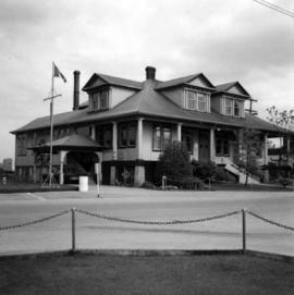
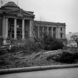
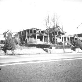
Photograph depicts a house that had been pushed on its side by a bulldozer.
Photograph depicts a house that provided an example of the few surviving homes left on Beach Ave.
Photograph depicts one of the surviving houses on Beach Ave, Vancouver, between Gilford and Chilco.
Photograph depicts a house that had a "sold" notice on it and was partly demolished. Up to the date the photograph was captured, this block on Beach Ave. was the sole remaining one to have only houses on it, as opposed to a mixture of houses and apartment blocks, or blocks only.
Photograph depicts a house that was probably built in 1890-1900. It had just been demolished.
Photograph depicts a house on the southern edge of Chinatown.
Photograph depicts the Great Northern Railway station on Main Street, Vancouver being demolished.
Photograph depicts Vancouver City College, formerly King Edward Secondary School.
Photograph depicts a Public Weigh Scale that was operated in Vancouver, on Main Street, opposite the CN Depot.
Photograph depicts what is believed to be the only remaining "summer cottage" on Beach Ave. in English Bay.
Photograph depicts a former Sailor's Home at the southeast corner of the intersection at Alexander St. and Jackson St. in Vancouver, B.C.
Photograph depicts the former "Terminus Hotel" on 32 Water St., 50 yards from the center of old Vancouver.
Photograph depicts the Mussenden Building used by the Hudson's Bay Company. It is located on Water St. in Vancouver, B.C. View is from the north side looking east.
Photograph depicts an old church or school being demolished at 1701-1721 West 3rd Ave. (and Pine), in Vancouver, B.C.
Photograph depicts a stone house on 17th St. and Esquimalt St. in West Vancouver, B.C.
Photograph depicts the corner building on West Georgia and Chilco St., facing Stanley Park in Vancouver B.C. View looking south across Georgia St.
Photograph depicts the Pacific Press Ltd. Vancouver Sun building at Beatty and West Pender St. The view is looking northeast from Beatty St. It was vacated by the Vancouver Sun at Christmas 1965 with the neon "Sun" sign on the tower removed.
Photograph depicts Pier B of C.P.R., just west of the C.P.R. railway station. This is the only pier accessible to ocean going passenger liners and is used by P&O vessels. Facilities generally in adequate for the 1960s.
Photograph depicts a former fire hall now used as a boy's club on 12th Ave and St. Catherine's St., in Vancouver, B.C. It is one and a quarter miles southeast of C.N.R. station.
Photograph depicts a courthouse in Vancouver, B.C. Photo shows the ripped up forecourt.
Photograph depicts a courthouse on Georgia St., looking west towards the Vancouver Hotel. The fence surrounding the courthouse is covered with paintings.
Photograph depicts a painting on the fence outside a courthouse on Howe and Granville St. In Vancouver, B.C. Each artist was granted a permit and panel by City Council.
Photograph depicts a general view of Coal Harbour in Vancouver, taken from its head in Stanley Park, looking east. The Bayshore Inn is shown on the extreme left of the image.
Photograph depicts the 1000 Beach Ave. block with dogwood rose tree in bloom at the left of the photo.
Photograph depicts an empty site at 1000 Beach Ave. in Vancouver, B.C.
Photograph depicts the upper end of Coal Harbour, on the south shore looking southwest and taken from the dock of the Vancouver Shipyards Ltd.
Photograph depicts a view looking northeast towards Coal Harbour from Alberni St. (Chilco-Gilford block) with West Georgia St. in the middle distance.
Photograph depicts a general view of Coal Harbour in Vancouver, looking southeast and taken from Royal Vancouver Yacht Club premises. Photo shows the Bayshore Hotel on the extreme left.
Photograph depicts the north shore of False Creek, looking west after a snowfall. Photo taken from the swing span of Cambie Bridge in Vancouver, B.C.
Photograph depicts the C.P.R. terminal in Vancouver. A C.P.R. switcher is collecting cars from the "Princess of Vancouver" at about 7 p.m.
Photograph depicts a tower controlling the C.P.R. grade crossing at Alexander St. in Vancouver, B.C.
Photograph depicts a CNR lifting bridge in Vancouver.
Photograph depicts a courthouse in Vancouver, B.C. Photo shows the ripped up forecourt.
Photograph depicts homes on 1000 Beach Ave., looking northeast.
Photograph depicts the ongoing wrecking of house #1053 on Beach Ave.
Photograph depicts the homes on 1000 Beach Ave. in Vancouver, B.C.
Photograph depicts the Vancouver Shipyards Ltd. on 555 Denman St. in Vancouver, B.C., looking south from Coal Harbour waters.
Photograph depicts the west end of Coal Harbour looking south to West Georgia St. and Chilco-Gilford block beyond. The old pilings exposed at low tide.
Photograph depicts Cadero St. in the west end of Vancouver, looking north from Barclay St. intersection in the 800 block.
Photograph depicts an old building at 119 Water St. in Vancouver, B.C.
Photograph depicts the headquarters and general offices of the National Harbours Board in Vancouver, B.C., located at the foot of Dunlery St.
Photograph depicts a home at 1310 Comox St. in Vancouver, B.C. View is of the east side of the house, facing Jervis St.
Photograph depicts the Buckingham Apartments at 925 Cardero St.and Barclay St. in Vancouver, B.C.
Photograph depicts a west end fire hall in Vancouver on Nelson and Nicola St.
Photograph depicts a church on a reservation at Mosquito Creek in North Vancouver, B.C.
Photograph depicts the Buckingham Apartments at 925 Cardero St. in Vancouver, B.C. after a snowfall. The view is looking south and depicts Barclay St. crossing in the foreground.
Photograph depicts the Sun Building at the intersection of Beatty and West Pender St. in Vancouver, B.C. The photo was taken after the Pacific Press Ltd. Vacated the building on December 26, 1965, and the "Sun" neon sign on the tower was removed. The view is looking west from West Pender St.
Photograph depicts houses being demolished on Beach Ave, West End, Vancouver.
Photograph depicts a well cared for house that was empty and being stripped along with 3 other house on Barclay to make way for a high rise apartment block. Built circa 1905.
Photograph depicts a house that at the moment was being pushed up on its side by a bulldozer.