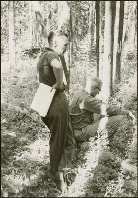
Item is a photograph of Ray Williston and John Liersch in a small wood area southwest of Prince George.
Cane floats in flooded area of camp, tent buildings and forest trees in background. It is believed that this photograph may depict the Island Cache in flood, at Prince George, BC.
View of 5 buildings and 4 tents on land that has been cleared to stumps. Printed annotation on verso reads: “HAMILTON AVE. FORT GEORGE”, added handwritten annotation in ink reads: “1910”.
Image depicts an aerial view of areas that have been used for logging around Prince George, B.C.
Image depicts a highway, and a section of mountain in the background which is bare due to clear-cut logging. It is possibly somewhere near Prince George, B.C.
Image depicts a logging area, and a section of mountain in the background which is bare due to clear-cut logging. The slide is also labelled "logging show." It is possibly somewhere near Prince George, B.C.
Image depicts logs being stripped of their bark at a saw mill in Prince George, B.C.
Image depicts a piece of heavy machinery lifting numerous logs off the back of a logging truck. It is likely located in Prince George, B.C.
Image depicts the shore line and surrounding land of a lake or river at an airport, possibly in Prince George, B.C.
Image depicts a cutbank on the Nechako River in Prince George, B.C.
Image depicts Tabor Mountain in the distance, located in Prince George, B.C.
Image depicts a long line of people cross country skiing somewhere on Tabor Mountain in Prince George, B.C.
Image depicts a skier in a costume with a fake sword, somewhere on the Birchleg Ski route on Tabor Mountain in Prince George, B.C.
Image depicts the area surrounding Tabor Mountain. Prince George is slightly visible on the left side of the image in the background.
Image depicts a forest of dead trees on the slopes of Tabor Mountain in Prince George, B.C.
Image depicts a the Cottonwood Island Nature Park sign and map in Prince George, B.C.
Image depicts the Fraser River from the vantage point of the cutbanks in Prince George, B.C.
Image depicts a view of Prince George from the cutbanks on the Nechako river.
Image depicts Prince George from the view of Peden Hill.
Image depicts an agricultural field, most likely near Prince George, B.C.
Image depicts a view of Prince George from Gunn Point in the L.C. Gunn Park looking north. Map coordinates 53°54'26.2"N 122°43'35.8"W.
Image depicts the Fraser River and the Yellowhead and Grand Trunk Railway Bridges from LC Gunn Park. Map coordinates 53°54'30.7"N 122°43'27.0"W
Image depicts the Northwood pulpmill in Prince George B.C.
Image depicts the Foothills Bridge over the Nechako river on the Foothills Boulevard in Prince George, B.C. Map coordinates 53°56'52.5"N 122°48'59.9"W
Image depicts a river, possibly the Nechako, in Prince George, B.C. Possibly taken from the Foothills Bridge.
Image depicts Haldi Lake near Prince George, B.C.
Image depicts Eskers Park, near Prince George, B.C.
Image depicts Pineview on Buckhorn Lake Road, Prince George, B.C.
Image depicts a snow sculpted fire place and couch on a skating rink, possibly during the Winter City Conference, in Prince George, B.C. Taken at the Prince George Civic Center. Map coordinates 53°54'45.6"N 122°44'59.6"W
Image depicts a snow sculpture of the Mr. P.G. lounging on a couch, possibly during the Winter City Conference, in Prince George, B.C. Taken at the Prince George Civic Center. Map coordinates 53°54'45.6"N 122°44'59.6"W
Image depicts the Northwood Pulpmill in Prince George, B.C. taken from above the Nechako River looking east. Map coordinates 53°56'00.0"N 122°44'29.7"W
Image depicts Prince George, with the picture looking North-Northeast from University Way.
Image depicts Prince George from University Way, with the P.G.I pulp mill in the distance.
Image depicts a cemetery in the South Fort George suburb of Prince George, B.C.
Image depicts a bridge in Prince George, B.C.
Image depicts a view of Prince George from an uncertain location.
Image depicts the Lheidli T'enneh Burial Grounds in Fort George Park.
Image depicts a view of Prince George.
Image depicts a road near the Ginter House in Prince George, B.C.
Image depicts a number of small houses at Island Cache.
Image depicts several old, ruined cars and an unknown individual in Island Cache.
Image depicts what appears to be an animal pen in Island Cache. There is a goat and numerous chickens in the image, as well as a pile of miscellaneous material.
Image depicts a few houses in Island Cache. There are two unknown individuals present.
Image depicts what is possibly a small section of the Nechako River on Cottonwood Island.
Image depicts a view of the south direction of the grade for the British Columbia Railway, which was formerly known as the Pacific Great Eastern until 1972. It is at an uncertain location, possibly near Woodpecker or Prince George.
File consists of:
- "A Summary of Historical Orders-in-Council affecting the Aleza Lake Forest Reserve", Mike Jull, 18 Dec. 1996
- Photocopied memorandum from F.S. McKinnon regarding "Transfer of Aleza Lake to D.F. Prince George", 9 Sept. 1963
- Photocopied 1928 article by P.M. Barr from Forestry Chronicle 4(3) entitled "The Aleza Lake Experiment Station: Its Development and Purpose"
- "A Brief History of the Aleza Lake Experiment Station", [Tim Decie, 1981?]
- Contact information for living relatives of Percy Barr, as of 1990
- Photocopy of 1930 article by Percy Barr entitled "Spruce Reproduction in British Columbia"
- Photocopy of records from BC Archives from a visit by Harry Coates from the file GR 1348 "The Young Mens Forestry Training Program"
- Photocopy of excerpt regarding "Amanita Lake/Diameter Limit Logging"
- Various small-scale maps and charts regarding Aleza Lake
- "Aleza Lake Research Forest Information Session Notes with Mike Jull, Manager of ALRF"
File consists of:
- "Devil's Club, Black Flies, and Snowshoes" by John Revel, 2007, 44 p. (3 copies)
File consists of:
- An original final draft of John Revel's problem analysis entitled "Silviculture in Spruce-Alpine Fir Types in the North Central Interior of British Columbia" for E.P. 639 with the Research Division of the BC Forest Service.