Affichage de 5116 résultats

Archival description
3026 résultats avec objets numériques Afficher les résultats avec des objets numériques
A House
2012.13.1.22.18 · Pièce · 1970
Fait partie de J. Kent Sedgwick fonds

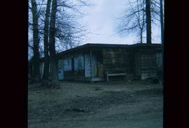
Image depicts a house in Island Cache. There are several cars parked outside it.

Sheds
2012.13.1.22.33 · Pièce · 1970
Fait partie de J. Kent Sedgwick fonds

Image depicts a number of sheds in Island Cache.

Sheds
2012.13.1.22.36 · Pièce · 1970
Fait partie de J. Kent Sedgwick fonds

Image depicts a number of sheds in Island Cache.

Wells
2012.13.1.037 · Sous-série organique · [between 1970 and 1980]
Fait partie de J. Kent Sedgwick fonds

File contains slides depicting Wells, B.C.

South Fort George
2012.13.3.1.50 · Dossier · 1970-2005
Fait partie de J. Kent Sedgwick fonds

File consists of notes, clippings, and reproductions relating to South Fort George. Includes: "South Fort George - A trip to the past" heritage brochure produced by South Fort George Community Association (1987) and "B.C. Express Co. Heritage Site" typed document prepared by the Heritage Advisory Committee (Feb. 1994). Also includes photographs depicting various buildings from old South Fort George.

Evaporation Gauge (Atmometer)
2012.13.1.121.07 · Pièce · July 1970
Fait partie de J. Kent Sedgwick fonds

Image depicts an atmometer. According to the slide, it is being used for measuring the rate of water evaporation "from carborundum stone." The location is uncertain.

Snow Gauge
2012.13.1.121.11 · Pièce · July 1970
Fait partie de J. Kent Sedgwick fonds

Image depicts a snow gauge at an uncertain location.

P.G. C.I. Geomorph
2012.13.1.124 · Sous-série organique · [between 1970 and 1977]
Fait partie de J. Kent Sedgwick fonds

File contains slides depicting landforms at various locations.

Intrusion
2012.13.1.124.01 · Pièce · 1970
Fait partie de J. Kent Sedgwick fonds

Image depicts what is possibly an intrusive volcanic landform somewhere near Miworth, B.C.

City of Prince George
2012.13.2.01.03.3 · Pièce · [after 1970]
Fait partie de J. Kent Sedgwick fonds

Map depicts the city of Prince George with annotations of the boundary expansions from 1915 to 1964.

Monkman Pass in newspapers
2012.13.2.14.25 · Dossier · [between 1970 and 1980]
Fait partie de J. Kent Sedgwick fonds

File consists of notes, clippings, and reproductions relating to the Monkman Pass mentioned in newspapers.

Transportation
2012.13.2.15 · Sous-série organique · 1970-2010
Fait partie de J. Kent Sedgwick fonds

Subseries consists of material collected and created by Kent Sedgwick for research regarding transportation. Includes notes and research on airplanes, specifically Prince George aviation and the Junkers aircraft named "The City of Prince George"; highway transportation; the Grand Trunk Pacific Railway; ferry boat service including the Fraser River Fort George ferry, the Isle Pierre ferry, and the Miworth ferry; the Pacific Great Eastern Railway line; the British Columbia Railway; and the Canadian National Railway. Also includes essays and typed documents on railway history in Prince George.

Ferries in Prince George
2012.13.2.15.09 · Dossier · [197-], 2005
Fait partie de J. Kent Sedgwick fonds

File consists of notes, clippings, and reproductions relating to ferry boat service in and around Prince George. Includes material regarding the Fraser River Fort George ferry; the Isle Pierre ferry; and the Miworth ferry. File also includes photographs depicting a building at Isle Pierre in the 1970s and the ferry crossing at Isle Pierre in 2005.

Isle Pierre
2012.13.2.15.09.1 · Pièce · [197-]
Fait partie de J. Kent Sedgwick fonds

The item is a photograph depicting a two story abandoned wooden building. Annotation on reverse side of photograph states, "Isle Pierre 1970s."

McBride - Yellowhead
2012.13.1.085 · Sous-série organique · [between 1970 and 2004]
Fait partie de J. Kent Sedgwick fonds

File contains slides depicting places in and between McBride and the Yellowhead Pass via the Yellowhead Highway.

Abandoned Cabin with Ivy
2012.13.1.87.117 · Pièce · [between 1970 and 1990]
Fait partie de J. Kent Sedgwick fonds

Image depicts an old and abandoned cabin with ivy growing up the side. The location is uncertain.

"Prince George Street Names A-Z"
2012.13.2.03.09 · Dossier · 1970
Fait partie de J. Kent Sedgwick fonds

File consists of the 1970 edition of "Prince George Street Names A-Z" compiled by the Prince George branch of Canadian Federation of University Women.

Prominent Figures
2012.13.2.10 · Sous-série organique · 1970-2010
Fait partie de J. Kent Sedgwick fonds

Subseries consists of materials collected and created by Kent Sedgwick for research on prominent individuals within Prince George and northern/central British Columbia. These individuals include various photographers, John Warren Meyer, Fannie Kinney, Father Adrien Morice, Henry Spencer Palmer, and Bridget Moran. The files also contain various other obituaries and materials regarding prominent individuals in Prince George.

Parks and Outdoor Recreation
2012.13.2.14 · Sous-série organique · 1970-2011
Fait partie de J. Kent Sedgwick fonds

Subseries consists of material collected and created by Kent Sedgwick for research regarding parks and outdoor recreation in Prince George. Material on parks includes Fort George Park (renamed to Lheidli T’enneh Memorial Park in 2015); Cottonwood Island Park; Connaught Hill; Moore's Meadow; L.C. Gunn Park; the Nechako Cutbanks; Paddlewheel Park; Monkman Provincial Park; Fraser Canyon Park; and Carp Lake. Also includes information on the creation of plaques and monuments, including the Alexander Mackenzie monument; the “Arrival of Steel” CN railway plaque; heritage interpretative signs for the Grand Trunk Pacific Railway; the Millar addition; and flooding and rivers. The files consists of various pamphlets and correspondence regarding the development of parks and the creation of interpretive materials.

2012.13.2.11.04 · Dossier · 1969-1989
Fait partie de J. Kent Sedgwick fonds

File consists of maps and aerial photographs of Prince George. Includes: "Record of gift" typed document to Kent Sedgwick (10 July 1989); "Map showing topography of the incorporated area of Prince George" reproduction of a map depicting topography and lot areas of Prince George, originally drawn 1926; BC5553 No 237" aerial photo reproduction depicting Prince George [ca. 1980]; "Prince George September 1969" aerial photo reproduction (Sept. 1969); and "3rd and Johnson" reproduction of an aerial photo depicting 3rd Avenue and Johnson St in Prince George [ca. 1970]."

Physical Landscape Features
2012.13.1.125 · Sous-série organique · [between 1968 and 1982]
Fait partie de J. Kent Sedgwick fonds

File contains slides depicting physical landscape features at various locations, most are from outside Northern B.C.

"Bowron Lake Park"
2012.13.2.19.04.1 · Pièce · June 1968
Fait partie de J. Kent Sedgwick fonds

The item is a map depicting Bowron Lake Park in British Columbia, the park boundary, the patrol cabin, roads, campsites, glaciers, and trails. Various handwritten annotations are written on the map and Public Shelters are circled in red pen.

Stake on Bare Ice
2012.13.1.121.03 · Pièce · 1968
Fait partie de J. Kent Sedgwick fonds

Image depicts an unidentified individual standing next to a marker and a stake at an uncertain location.

Survey Equipment
2012.13.1.121.06 · Pièce · [1968?]
Fait partie de J. Kent Sedgwick fonds

Image depicts objects, including a flag pole, that the slide labels as "survey equipment." The slide also places it as a "Peyto icefall," on the Peyto Galcier in the Banff National Park in Alberta, B.C.

2012.13.2.02.67 · Dossier · 1968
Fait partie de J. Kent Sedgwick fonds

File consists of a pamphlet titled "The Fort Fraser-Fort George Bulletin Area" prepared by the Department of Lands, Forests, and Water Resources from the Province of British Columbia.

"British Columbia Relief Map"
2012.13.6.50 · Dossier · 1968
Fait partie de J. Kent Sedgwick fonds

Item is an original 1968 map depicting British Columbia and its reliefs, including hills, valleys, and mountains across the province. The map was published by the British Columbia Department of Lands, Forests and Water Resources.

Quesnel, Barkerville, and Wells
2012.13.2.19.04 · Dossier · 1968, 1980, 2002-2010
Fait partie de J. Kent Sedgwick fonds

File consists of notes, clippings, and reproductions relating to Quesnel, Barkerville, and Wells. Includes: "An Historic Walk of Carson Avenue, Quesnel, B.C". pamphlet prepared by the Quesnel Branch Cariboo Historical Society (1990); "Wells, B.C". pamphlet by the Wells Historical Society (1980); "Cottonwood House Provincial Historic Park" pamphlet by the Province of British Columbia (1980); and vol. 1 of the Cariboo Gazette newspaper (2002). Also includes a map depicting Bowron Lake Park in British Columbia (1968).

Scenery
2012.13.1.47.18 · Pièce · 1968
Fait partie de J. Kent Sedgwick fonds

Image depicts a scenic view of a mountain and forest at an uncertain location.

Ice Drilling
2012.13.1.121.05 · Pièce · [1968?]
Fait partie de J. Kent Sedgwick fonds

Image depicts an unidentified individual drilling into the ice.