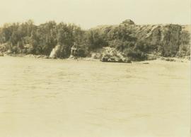
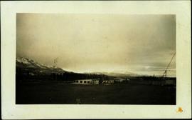
Showing 4832 results

Archival description
4073 results with digital objects Show results with digital objects
2011.3.2.05 · Item · 1913
Part of North Coast & Central BC Postcard Collection

Lofty view of South Fort George, river and treed hills in the background. Printed annotation on verso reads: “South Fort George - 1913.” Handwritten message on recto is addressed to “Ethel M. Heurris Norton Maps Bristol County" reads: "11-1-13 an excellent view of south Fort George taken recently. Power Station at cross near water. This does not give all the south residence view. Population approx 1500”.

2006.45.17 · Item · [ca. 1897]
Part of Historical North Coast Photograph Album

View of town on shore, from above. Boats docked along piers and buildings. Hills visible on either side of water in background.

Handwritten photo captions with arrows pointing to sections of image read: "General Merchandise", "Fort Wrangell Hotel".

2013.6.36.1.015.14 · Item · 15 Oct. 1974
Part of David Davies Railway Collection

Photograph depicts an unnamed harbour road that runs to the north of , and parallel to Water St. The trackage is connected behind the camera to a CPR depot and at the other end to the mainline. No spurs lead off to the docks. The track is not used but usable.

2011.3.2.13 · Item · 1921
Part of North Coast & Central BC Postcard Collection

Boardwalk in foreground, buildings and roads in mid ground, cut banks in background. Printed annotation on recto reads: “Prince George. B.C. 1921 by Moore”. Handwritten annotation in ink on verso reads: “The Netchaco river is between the mountain and the city and the C.N.R. runs along the river bank nearest the city. This picture is taken looking north.”

View of Seton Lake area
2020.08.77 · Item · [between 1911 and 1915]
Part of Pacific Great Eastern Railway Region Photograph Collection

Photograph depicts a view of Seton Lake and the surrounding area, including the Pacific Great Eastern railway line. The railway grade is visible at left. Also visible is the Seton Lake fish hatchery at the east end of the lake and its employee boarding house, superintendent's cottage, and weir at the head of what was then referred to as "Lake Creek". The road seen in the centre foreground travelled from Lillooet to Seton Lake then to Golden Cache Mine.

View of Summit Lake
2005.3.50 · Item · [ca. 1945]
Part of John Hart Highway Photograph Collection

Handwritten caption beside this photo reads: "Sumit Lake." Trees can be seen on shore jutting into the lake on left, as well as on opposite shore in distant background. Unidentified objects can be seen in distance, possibly buildings on far shore.

2013.6.36.1.003.101 · Item · [May 1966]
Part of David Davies Railway Collection

Photograph depicts a view of the Fraser River from the Albion Ferry from Haney to Fort Langley. The ferry is approaching the south bank of Fort Langley. Gulls sat on logs floating downstream; too heavy to rise after eating candlefish.

2006.20.12.35 · Item · [ca. 1940]
Part of Northern BC Archives Historical Photograph Collection

Handwritten photo album caption below this photo reads: "Above the Rockies at 12 000 feet." Photograph depicts the Rocky Mountains from a distance. As the photograph was taken from the inside of an airplane, the plane's wing tip can be seen on the far right of the image. A sun circle is also visible in the top center.

Royal Canadian Air Force
2013.6.36.1.026.18 · Item · [22 June 1979]
Part of David Davies Railway Collection

Photograph depicts a view of four tracks at the McCulloch CPR depot, located at mile 76.6, on the Carmi Subdivision. The four tracks, west to east, are: a passing track, the mainline, a storage track, and a turning "Y". The rail on the passing track and mainline are date 1940, and the others are 1918 or 1919. The view is looking southwest.

2006.20.12.43 · Item · [ca. 1940]
Part of Northern BC Archives Historical Photograph Collection

Handwritten photo album caption below this photo reads: "Another view of Whitehorse Field from the Tower." Photograph depicts various unidentified buildings at what is believed to the Royal Canadian Air Force base in Whitehorse, YT. Small sign in foreground reads: "Taking Photographs Prohibited" (see also items 2006.20.12.1 & 2006.20.12.39). Mountains in background.

Royal Canadian Air Force
2000.1.1.3.15.31 · Item · June 1970
Part of Cassiar Asbestos Corporation Ltd. fonds

Photograph depicts Wabco in left foreground in front of shop building, tractor, and miscellaneous supplies. Mine valley and mountains in background. Handwritten annotation on recto of photograph: "Cassiar B.C. 1970 June 23 by Tom Kiefer".

W.A.C. Bennett Dam?
2012.13.1.91.44 · Item · 1979
Part of J. Kent Sedgwick fonds

Image depicts several unidentified individuals lying on a hill outside what is most likely the W.A.C. Bennett Dam in Hudson's Hope, B.C.

2009.5.1.73 · Item · 26 May 1932
Part of Taylor-Baxter Family Photograph Collection

Handwritten annotation on recto of photograph: "Omineca Dist Walcott Suspension Bridge West Approach - looking East May 26 - 1932". Photograph depicts two white horses pulling a wagon in front of Walcott bridge. This bridge was moved from its original location in the Hagwilget Canyon, downstream from Walcott on the Bulkley River. It is a pedestrian bridge at the time of this photograph, though it was originally used by motor vehicles. Dirt road leading to bridge in foreground, with lumber and brush piles on either side. Trees and hills on opposite shore in background.

Wartime Freight
2013.6.29.27 · File · 1995-2019
Part of David Davies Railway Collection

File consists of:

  • Canadian Rail issue no. 447 (July-August 1995) which is devoted to Canada's Railways in World War II
  • Article by David Davies, "Wartime Freight in BC in WWII, 1939-1945"
  • Summary piece by David Davies, "What happened in British Columbia in WWII? 1939-1945: A Review of Military Events"
2013.6.36.1.026.08 · Item · [22 June 1979]
Part of David Davies Railway Collection

Photograph depicts the washrooms on the west side of the line, about a quarter mile from the McCulloch CPR depot building. The depot is located at mile 76.6 on the Carmi Subdivision.

2013.6.36.1.028.42 · Item · 18 Sept. 1970
Part of David Davies Railway Collection

Photograph depicts water car #415319 standing on a little used spur in Nelson. It consists of a locomotive tender mounted on a flat car. It could be used as a firefighting unit, but it is merely lettered "service."

2013.6.36.1.027.19 · Item · [July 1966]
Part of David Davies Railway Collection

Photograph depicts a water tank car on the CPR line at Rock Creek. Rock Creek is located at mile 11.7 from Midway and east of Osoyoos. The water tank car was built in 192, holds 8000 gallons, and forms part of a work train. The sidings capacity here is 70 cars.