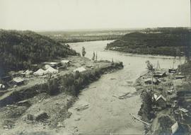
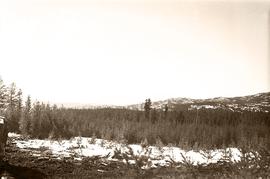
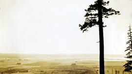
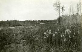
Typed caption glued to album page directly below photograph reads: "33. View of Fort Fraser one year ago." Photograph depicts a cleared section of land in the fore and mid grounds, and the wooden framing of a structure under construction in the background. Photographer: Dominion Stock & Bond Corporation.
Handwritten caption above this photo reads: "Earth Cut". Photograph depicts the steep slope of man-made embankment, trees in background. Tracks made my machinery are visible in dirt of the cut.
Photograph depicts the steep slope of man-made embankment. Forest in background, level excavated ground in foreground.
Photograph depicts the steep slope of man-made embankment, trees in background. Tracks made my machinery are visible in dirt of the cut.
Photograph depicts the steep slope of man-made embankment, forest in background at bottom of slope. Small twigs and pant leg of unidentified individual in foreground.
Hand coloured view of early Prince Rupert with row of tents facing large Hotel. Printed annotation in red ink on recto reads: “The Beginning of Prince Rupert B.C.: Grand Trunk Pacific Hotel in foreground”.
Caption describing photograph: "Eaglet Lake, Giscome. Low land lacustrine deposits. Cleared for forage crops and pasture. Willow and alder on right - typical cover prior to clearing. Refer to GBW Film 1 Frame 3 ( 2007.1.30.2.003 )"
Image depicts downtown Prince George taken from across the Nechako River looking south. Map coordinates 53°56'00.0"N 122°44'29.7"W
One man can be seen on crusher building framework, unidentified equipment and long metal rods in foreground. Power lines, a large tank, and other small buildings are semi-visible on a level in the mountainside just above the crusher building. Sky can be seen in background.
Men can be seen working on site. Crusher building in midground, chutes can be seen crossing the different levels of foundation. Lumber is leaning against excavated dirt wall in foreground, as well as a ladder which reaches up to the base level. Large tank can be seen in top level above building construction. Mountaintop and sky in background.
View showing various levels of foundations. Men can be seen working on site. Vertically protruding planks from framework in foreground. A long building believed to be housing conveyor "B" can be seen in background, as well as the tree-covered valley.
View facing into mountainside and showing various levels of foundations. Men can be seen working on site. Unidentified machinery and pile of long metal rods in foreground.
Men can be seen working on site, building tools and supplies scattered throughout. Handwritten caption beside this photo reads: "View showing various levels of foundations". A chute of some kind extends from high level to men near bottom. Dirt road at site, and tree-covered valley can be seen in background. Construction of a long structure near the edge of the excavation area can be seen in midground; this is believed to be conveyor "B".
Photograph depicts a general view of the C.P.R. yards adjacent to Ballantyne Pier in Vancouver. The sheeted units in the middle distance consist of an export train of 11 locies, travelling dear, just brought in by the G.N.R. switcher. The locomotives were built by General Motors, Electro-Motive Division in La Grange, Illinois. For shipment to Korean National Railways, Pusan. Diverted to Vancouver because of the U.S. Pacific Coast long shoreman strike.
Photograph depicts a view of the CPR mainline and siding at Salmon Arm. The view is looking east but the photo was taken from west of the depot. A work train was stored on the siding/spur behind the camera, protected by a metal flag.
Photograph depicts Copper Mountain with forested area at base and grassy area in the foreground.
Photograph is part of a series of photographs depicting Olin Corporation's Fria location.
Photograph is a copy print of artwork entitled "View of City from UNBC Prince George Campus Site" by June Swanky Parker.
Image depicts a view of Prince George from City Hall looking northeast along George Street. Includes a back view of the Prince George cenotaph. Map coordinates 53°54'46.3"N 122°44'41.9"W
Photograph depicts the confluence of the Cayoosh Creek outflow into the Fraser River in Lillooet, BC. Seton River is visible in the foreground. This area is Cayoose Creek Band (Sekw'el'wás First Nation) territory and includes land currently encompassed within Cayoosh Creek Indian Reserve 1. The Pacific Great Eastern Railway bridge over the Fraser River is also visible in the background.
Photograph depicts a view of cannery buildings from the shoreline with mountains in the background.
Part of a set of 41 original black & white photographs (1908-1914) of the Grand Trunk Pacific Railway line in BC depicting surveying crews, town sites (Prince Rupert and its port, Hazelton and Fort George), and First Nations Peoples. Most of these photos have descriptions written on the back.
Photograph depicts a view of Burns Lake, as seen from the survey crew's temporary lodgings at the cabin of Ben[?] Smith. Wyness notes in the photograph transcription that float planes landed in the bay below the buildings visible in this image.
Photograph taken during European Sports Tour with Team Canada. See also item 2009.6.1.241 for image featuring similar content.
Handwritten annotation on verso reads: "Budapest". See also item 2009.6.1.238 for image featuring similar content. Photograph taken during European Sports Tour with Team Canada.
Photograph taken during European Sports Tour with Team Canada.
Photograph depicts a mountainous area between Bella Coola and Anahim Lake.
Photograph depicts a view of the town site of Britannia Beach from a copper ore bin, above the concentrator.
Photograph depicts a view of cleared valley land with some buildings. Handwritten annotation below the photograph reads, "near Boundary Bay Oct. 1926"
Handwritten caption beside this photo reads: "View of Bin and Pan Feeder". Interior view of crusher building. A square, snow-covered object is being lowered by crane into building.
Alpine Club of Canada clubhouse
Photograph depicts town in distance, believed to be Atlin, B.C. Lake in foreground, hills in background. See also items 2009.5.2.63 & 2009.5.2.64.
Mount Assiniboine Provincial Park
Photograph depicts three men on Asbestos Mountain who are believed to be members of George Edzerza's expedition party during an exploration of the future mine at Cassiar.
Handwritten annotation on verso in blue ink describing sections of photograph which have been pointed to or outlined in blue ink: "LOOKING SOUTH" "ORE ZONE <500' [?] >" "'FLUFF' AREA" "2 MEN" "1 MAN" "OVER -->"
Handwritten annotation on recto in blue ink: "The shaded areas do not indicate 'fluff' necessarily - They are shadows from mountains. The size of the men will give you some indication of the distance".
Photograph depicts three men on Asbestos Mountain who are believed to be members of George Edzerza's expedition party during an exploration of the future mine at Cassiar.
Item is a photograph of a copy print, resulting in a low quality photographic reproduction. Reproduced as a print, slide, and a negative. Location of original photograph is unknown.
Photograph depicts the interior of an airport with seats.
Photograph depicts a view of a snow-covered mountain range.
Photograph depicts a view of fishing boats at Masset.
Photograph depicts the view to the north from the terminal building at the Rainbow Lake Ski Club.
Photograph depicts the view from the side of Jack Henderson-Roe's log cabin. A mountain and forests form the background; a home-made toboggan leans against the side of the cabin. Reads on verso as follows : "View looking towards my Western boundary which lies just this side of the distant hill. Taken after a heavy thaw, hence the patches of bare earth on the southern shapes of the hill. A home-made toboggan in this foreground. (8)".
Photograph depicts a view in a lane on the south side of the 1300 block of Richards St. in Vancouver. It includes a Louisville & Nashville car # L&N 109534, that is "paper loading only", has blue paintwork, and was built in June 1953. The end of the spur is at about Drake St. but it is covered in gravel for the last 25 yards. The car was spotted at the Cascade Imperial Mills Ltd. located at #1205 Richards St. Two-thirds of the block is occupied by the Johnston Terminals, Merchandise Storage Division. The building has 6 rail access doors but only 4 are in use. There is usually at least 1 car spotted along the building.
The item is a photograph depicting a dip between two hills of Woodpecker Landing Road. Annotation on reverse side of photograph states, "cut at powerline Woodpecker Ldg. Rd."
Hand coloured photo of lumber piles and buildings along the edge of the railway. Printed annotation on recto reads: "Prince Rupert, B.C. : View from Wharf Grand Trunk Pacific Railway." Artist's mark in lower left corner reads: "103,110 J.V."
Handwritten photo album caption below this photo reads: "Another view from Tower at Whitehorse." Photograph depicts various unidentified buildings, vehicles, and machinery behind dirt road in mid ground. Power poles in foreground; trees, river, and mountains in background.
Royal Canadian Air ForcePhotograph depicts a view of an old house from an unknown tourist attraction.
Wales, Great Britain