The Fred Jeffery Collection consists of three photograph albums comprising a total of 303 b&w photographs all dating from ca.1924-1933. The subject matter of these images consist primarily of the fishing industry, river & landscapes, salmon cannery images (housing, people, workers, machinery, boats) on the Nass River and North Pacific Coast. Notable are the photographs depicting indigenous (Nisga'a) people and places and Chinese and Japanese cannery workers. Identified canneries featured in these photographs include: Mill Bay Cannery, Namu Cannery, Klemtu Cannery, Shushartie Bay Cannery, Balmoral Cannery, North Pacific Cannery, Nass Harbour Cannery, Port Essington Cannery, Kitwanga Cannery, Port Nelson Cannery, Alert Bay Cannery, Dominion Cannery and ABC Co. Cannery. Photographs also include images of the Canadian Pacific Railway in both Vancouver and Sicamous, BC., as well as, images of the Legislative Assembly buildings in Victoria, the 1924 Special Service Squadron ships in Vancouver, early construction of the University of British Columbia in Vancouver, and town overviews of Yokohama, Japan (pre WWII).
Jeffery, FredPhotograph depicts two men standing to left of Fred Murray on balcony of large building or structure speculated to be in the Cassiar valley. Portion of log structure in left foreground, man and hauling trucks on road in background.
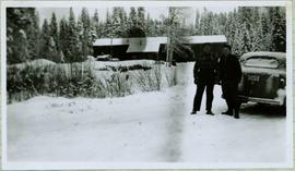
Handwritten caption above this photo reads: "Fred Youngstrom in [church shirt?]" Photograph depicts two men (Fred on left) standing on snow-covered road in front of car with a British Columbia license plate "93-650". A wood pile and long building with porch can be seen in background in front of forest trees. It is believed that this photo was taken at the camp in Summit Lake, B.C. (see item 2005.3.57).
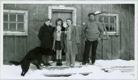
Handwritten caption beside this photo reads: "Fred Youngstrom & Kitchen Staff. 1946." Photograph depicts Fred standing to right of three woman, a young girl, and a dog. The group is standing on the snow-covered front steps of a (kitchen?) building, lumber pile on far right. A large metal triangle is hanging behind Fred. It is believed that this photograph was taken at the camp at Summit Lake B.C. (see item 2005.3.57).
Photograph depicts a freight truck carrying timber at Peden Hill Sawmill.

Photograph depicts two log buildings in fenced area on lake shore, forest trees in background. A man can be seen standing near docking area and small boat pier extending into water in foreground. Handwritten annotation on recto of photograph: "Fur Farm Red Rock Lake". This location is believed to at mile 27, north of Summit Lake.
Handwritten annotation on recto of photograph: "FURNACE PAD AUG 25/64." Photograph depicts construction worker standing on elevated wood platform. Three other men can be seen working in construction area. This location is believed to be under the conveyor to crusher building, retaining wall in midground.
Subseries consists of photographic material pertaining to the following subject areas: mine operations; plant operations;labour strike 1970s images; townsite operations of the company towns of Cassiar and Clinton Creek (including community activities associated therein and townsite development); as well as, images of mines not owned by Cassiar Asbestos Corporation, but which are believed to have been used for operational research purposes.
An assortment of photographs speculated to have been used for research purposes as Cassiar administration established the mine and the town.
File includes six aggregations of photographs which have been assembled in this file in order to maintain the integrity of each group by keeping the photos arranged together, though each group features operations pertaining to multiple files in this subseries. Includes groups featuring photos from 1961, 1965 1971, a helicopter trip, a community album, and a workplace album. Photographs depict images pertaining to the following operations at Cassiar, B.C.: mining, milling, maintenance, labratory tests, and tramline and town operations. Images featuring operations of the company town include the grocery store, bank, churches, school, library, lounge, pool, theater, community center, outdoor recreation, hospital, dentist, cafeteria, bus route, residences, air strip, firehall, laundromat, park, police, and newspaper.

Photograph depicts a general view, looking north, of Westview Harbour with the Powell River paper plant smoking in the background.
The file contains eight photographs depicting close up images of three rock samples, some photographed with a ruler for scale. One of the rock samples is speculated to be obsidian and the other two are likely serpentine. The images where originally found in an envelope titled "ROCKS" and are likely dated around 1991.
Included in this file are an five photographs of rocks on a shelf, which may be asbestos sample rocks. There are five accompanying negatives to these photographs and are likely dated around 1977. The photographs and negatives were found in an envelope labelled "Negatives - CIMM Photos."
Additionally two negative strips of geology maps of Canada. These negatives were found in an envelope labelled "Negatives - CIMM Papers, Mining, Planning, Geology."

Image depicts an unknown woman standing in front of a truck that either weighs 80 tonnes, or is capable of carrying that much; the slide is simply labelled "80 tons." It is located at the Gibraltar mine site.

Image depicts the interior of the Gibraltar chemical mill, where they separate the molybdenum.

Image depicts the Gibraltar mine site north of Williams Lake, B.C.

Image depicts an 80 tonne truck full of rocks at the Gibraltar mine site north of Williams Lake, B.C.

Image depicts a number of workers putting in blasting powder at the Gibraltar mine site north of Williams Lake, B.C.

Image depicts a loading truck at the Gibraltar mine site north of Williams Lake, B.C.

Image depicts an aerial view of the Gibraltar mine site's pits and waste dumps, north of Williams Lake, B.C.

Image depicts an aerial view of the Gibraltar mine site's pits and waste dumps, north of Williams Lake, B.C.

Image depicts the remains of a street of houses in Giscome, B.C. The quarry is slightly visible in the background. Map coordinates 54°04'20.9"N 122°21'53.1"W

Image depicts the Giscome mill site in Giscome, B.C. The bunkhouse is the large building with many windows. A train and railroad tracks are in the foreground. Map coordinates 54°04'17.6"N 122°22'06.1"W

Image depicts several houses and the Giscome saw mill in Giscome, B.C. in the background. Map coordinates 54°04'20.9"N 122°21'53.1"W

Image depicts the mill site at Giscome, B.C. Map coordinates 54°04'19.7"N 122°22'04.7"W

Image depicts the mill site at Giscome, B.C. A sign in the foreground reads "Maynard's Industrial Auctioneers." Map coordinates 54°04'19.7"N 122°22'04.7"W

Image depicts the mill site at Giscome, B.C. Map coordinates 54°04'19.7"N 122°22'04.7"W

Image depicts the mill site at Giscome, B.C. Map coordinates 54°04'19.7"N 122°22'04.7"W

Image depicts the mill site at Giscome and its beehive burner. Map coordinates 54°04'19.7"N 122°22'04.7"W

Image depicts a food stand at the mill site at Giscome, B.C. Map coordinates 54°04'19.7"N 122°22'04.7"W
This photograph collection consists of 53 photographs featuring primarily Giscome with a few of Prince George. Subjects include the Eagle Lake Sawmill, Eagle Lake, Giscome townsite (including specific buildings and general road perspectives), Giscome School, Division II class photos (1950-51), and the Giscome School teacherage.
File consists of collected research materials regarding the Grand Truck Pacific Railway. Materials include brochures, newspaper clippings, a CN supplement, a bibliography, pamphlets, correspondence, photographs, and reproductions of articles. Highlights include:
- Fraser Fort George Museum, "Grand Truck Pacific: The Transcontinental Line", 1983 (exhibit brochure)
- CN Mountain Region Supplement 1 employee time table for June 21, 1978
- CN Headquarters Library, "A Selected Bibliography on Canadian Railways", Special Series No. 25 6th edition, 1968
- Greater Victoria Public Library, "Railroads & Railroading in Canada: A selected booklist", 1988 (pamphlet)
- Stephen Ruttan, "Transportation in British Columbia", 1985 (pamphlet)
- Fort George Regional Museum, "Fort George Railway, Prince George B.C.", [198-?] (pamphlet)
- Bulkley Valley Historical and Museum Society, "Smithers Grand Trunk Pacific Freight and Passenger Division Headquarters", 1978 (booklet)
- Prince George Railway Museum, "On Track" newsletter, Vol. 9 No. 6-7 July, 1991 (newsletter)
- Central British Columbia Railroad Preservation and Museum Society, "On Track" newsletter, Vol.3 No.5 1985 (newsletter)
- BC Provincial Archives of British Columbia Aural History Programme, "The Grand Trunk Pacific", Interviewed by Imbert Orchard, People in Landscape Educational Series, 1969 (booklet)
- Reproduction of BC Archives photograph depicting the Grand Trunk Pacific Railway entitled "Camp near Burns Lake", Aug 1912
- Reproduction of BC Archives photograph depicting the Grand Trunk Pacific Railway entitled "G.T.P. Steel bridge across the Shuswap River, Mile 79, 12 miles east of McBride", [191-?]
- Reproduction of BC Archives photograph depicting the Grand Trunk Pacific Railway entitled "Prairie Creek Bridge nearly completed, 5 miles west of Hilton", [191-?]
- Reproduction of BC Archives photograph depicting the "McKenzie & Blais store", [191-?]
- Reproduction of BC Archives photograph depicting the Grand Trunk Pacific Railway entitled "Linking up of Steel on G.T.P. Transcontinental, Fort Fraser", 1914

Image depicts an 80 tonne truck at a mine site somewhere in Granisle, B.C.

Image depicts numerous bags of blasting powder at a mine site somewhere in Granisle, B.C.

Image depicts a drill for blasting holes at a mine site somewhere in Granisle, B.C.

Image depicts a large, electric shovel at a mine site somewhere in Granisle, B.C.

Photograph depicts close up view of gravel pit, ruler displayed for scale. Photograph speculated to have been taken at the plant or near the Cassiar airstrip. Stamped annotation on recto of photograph: "JUN. 1987".

Handwritten caption below this photo reads: "Bought in Picture Prince George". Photograph depicts a grizzly bear walking on all fours in forest area, slash debris in background.
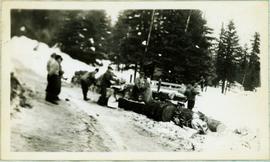
Photograph depicts a group of men working with tools around thick logs, piles of firewood behind them. They are in a snowy area with trees in background.
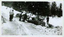
Handwritten caption above this photo reads: "Making Fire Wood." Photograph depicts a group of men working with tools around thick logs, piles of firewood behind them. They are in a snowy area with trees in background.

Photograph of a partially sunken sailboat near a harbour. Individuals on debris and in a rowboat are surveying the damage. Annotation on recto reads: "GTP. SS Prince Rupert Sept 28th 1920 McRae." Handwritten annotation on verso reads "CTP "Prince Rupert" Sunk at Prince Rupert BC 1920."

View of building, dock, harbour and small islands with snow peaked mountains in background. Printed caption on verso reads: “Port Essington B.C. Photo by P. E. Fisher”. Handwritten annotation in ink on verso reads: “up the Skeena”, in pencil on verso: “Port Essington, North Coast Commercial Coy”.

Boats, docks, ships and a large building in waterscape. Printed annotation on recto reads: “Prince Rupert B.C.” Handwritten annotation in pencil on verso reads: “McRae Bros”.
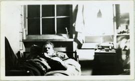
Handwritten annotation on recto of photo reads: "Harry Monson Edmonton Prince George." Harry reclines on bed under window, surrounded by personal effects. Photograph was taken after nightfall. Handwritten caption beside this photo reads: "Harry talked my dad into selling him my boat".

Image depicts a piece of heavy machinery lifting numerous logs off the back of a logging truck. It is likely located in Prince George, B.C.

Image depicts a piece of heavy machinery lifting numerous logs off the back of a logging truck. It is likely located in Prince George, B.C.

Image depicts a piece of heavy machinery lifting numerous logs. It is likely located in Prince George, B.C.
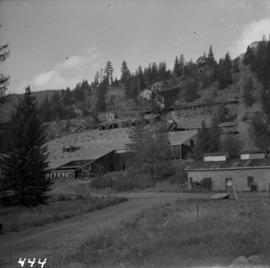
Photograph depicts the Hedley Gold Mine, 26 miles east of Princeton. Crusher workings.

Photograph depicts crusher plant in centre foreground. Shifter shack and vehicles can be seen in front of pit area. West Peak semi-visible in right midground. Mine valley an northwestern mountain range in background.

Photograph depicts the West Peak of the Cassiar mine on McDame Mountain. Pit area visible between West Peak and road in foreground. Mine valley and north mountain range in background. Photo speculated to have been taken from a point on or near the South or North Peak.