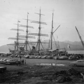
Photograph depicts a Japanese cade training ship called "Kaiuo Maru" at Centennial Pier, Vancouver. Its visit was part of 1966 Vancouver Sea Festival and the ship was open to the public for inspection.
Photograph depicts work in progress on a new CNR lifting span bridge.
Photograph depicts a house being gutted, prior to demolition.
Photograph depicts one of four houses that were being gutted and demolished to make way for a concrete high rise apartment block. Built circa 1905.
Photograph depicts a frame house in Vancouver. A high rise apartment on Barclay Street was being built and was just appearing in the background.
Photograph depicts a few houses on Beach Ave., Vancouve. They were examples of about a dozen surviving homes on Beach Ave.
Photograph depicts the rear view of Ridgewood Studio, Ltd., furnishers and furniture renovators. The wood shed was used for repair and repolishing of furniture.
Photograph depicts the possible remains of a WWII armoured personell carrier that belonged to a used machinery firm that was soon vacating due to land clearance.
Photograph taken at the main main fire station on the site of the former RCAF station near the Vancouver Airport. Visible is foam pumper #2, operated by the Federal Department of Tranpsort, as well as a Sicard truck.
Photograph depicts a monoplane called the "Seabee Amphibian." It was a 3 seater and produced by the Republic Aviation Corp. About 10 of these aircraft were grouped together near the Vancouver International Airport on Sea Island. All were separately owned and in different finishes and states of care.
Photograph depicts an apron opposite a CPA main hanger.
Photograph depicts a goodyear Blimp cruising over the Centennial Museum near Sunest Beach, False Creek, Vancouver. It came for the 1973 Abbotsford Air Show.
Photograph depicts the Georgia Viaduct in Vancouver. Image taken 5 days after its closure on June 28, 1971.
Photograph depicts a fire in the second floor bedroom of a house on Nelson Street.
Photograph depicts a view of Vancouver's West End.
Photograph depicts a restored pump car outside a pub on Permbeton Avenue, North Vancouver.
Map depicts the city of Vancouver and its railways.
Photograph depicts the False Creek Trestle bridge open and the Granville Bridge looking east.
Photograph depicts the piers of the south tower on the Lions Gate Bridge in Vancouver, BC
Photograph depicts the Lions Gate Bridge on west side looking south from the shore of North Vancouver, BC
Photograph depicts the Second Narrows railway bridge in Vancouver from the south bank. The bascule does not move.
Photograph depicts the north side lifting tower of the Second Narrows railway bridge in Vancouver, BC
Photograph depicts the Second Narrows Railway Bridge in Vancouver, BCwith the lifting span up.
Photograph depicts the road and rail bridges at Second Narrows, Vancouver B.C. The photograph was taken from Boundary Rd. looking north.
Photograph depicts the rail approach to the Second Narrows Railway Bridge in Vancouver, BCThe shot taken on CPR trackage and from underneath the road bridge on the south bank.
Photograph depicts the Second Narrows Railway Bridge, looking east.
Photograph depicts the road bridge crossing the south section of the north arm of the Fraser River at Fraser St. The view is from the north bank of Lulu Island.
Photograph depicts the Fraser St. road bridge over the north section of the north arm of the Fraser River, looking north from Mitchell Island to Vancouver, BC
Photograph depicts the Cambie St. Bridge in Vancouver, BC, looking southeast and showing the southern fixed span on the bridge.
Photograph depicts a bandstand at English Bay in Vancouver, B.C.
Photograph depicts the building for the Vancouver Supply Company located at 25 Alexander St. in Vancouver, B.C. It is at the center of the old downtown and may have been a former fire hall.
Photograph depicts the former C.P.R. route connecting existing False Creek rail yards and the Burrard shoreline main line. The view is looking southwest from the intersection of Powell St. (in foreground) and Columbia St. (not seen) in Vancouver.
Photograph depicts the Grand Central Hotel at the intersection of Marpole Ave and Hudson St. in south Vancouver. The hotel was built in 1912 by J.J. Graver and run from 1913-1915. It re-opened in 1920 as a home for incurables (veterans). In 1937 it became the provincial infirmary and closed in May 1965.
Photograph depicts a corner building on Chilco and West Georgia St. facing Stanley Park in Vancouver, B.C. The view is looking east across Chilco St.
Photograph depicts the site of a former C.P.R. connection between the mainline into Vancouver and False Creek yards at West Pender St. In Vancouver. The rails are not used but still appear in the street and on the parking lot on the far side. Another parallel set of tracks 30 yards to the east are in daily use.
Photograph depicts East Pender St., looking west towards the Vancouver Sun newspaper office near Abbot St. in Vancouver, B.C.
Photograph depicts Alberni St. in the west end of Vancouver. It is directly opposite the Vehicle Testing Station, in the 1700 block. The view in the photo is looking east.
Photograph depicts a courthouse in Vancouver, B.C. surrounded by a fence with paintings.
Photograph depicts a painting on a fence outside a courthouse on Howe St. in Vancouver, B.C. The painting shows the natural grandeur of B.C. partially blocked out by a super motel with a bewildered moose forced to become an ornamental fountain. The whole forecourt is being bulldozed to make way for the Centennial fountain.
Photograph depicts house at #1053 Beach Ave. in Vancouver, B.C. Dan Davies was a resident at one time.
Photograph depicts Beach Ave. in Vancouver, with the photo taken near the swimming pool and looking west. Photo was taken after a storm.
Photograph depicts home at #1053 Beach Ave., which is now fully demolished.
Photograph depicts a general view of Coal Harbour in Vancouver, looking southeast and south with Marine Building (downtown) on extreme left and Stanley Park (unseen) at extreme right.
Photograph depicts the general view of the waterfront buildings between Burrard and Thurlow St., in Vancouver Harbour looking northwest from Burrard St. The Immigration Building is on the left and the "Princess of Vancouver" (C.P.R.) is in the middle distance.
Photograph depicts the north bank of False Creek in Vancouver, B.C. The photograph was taken from the Cambie Bridge, with a view looking west.
Photograph depicts former tram tracks, looking north from the intersection at Campbell Ave and east Georgia St. in Vancouver, BC
Photograph depicts a West Coast Railway Association locomotive and car at a C.N.R. station in Vancouver. The trackage actually belongs to a demolished Great Northern Railway Station.
Photograph depicts a train at the Great Northern Railway Station in Vancouver, B.C.
Photograph depicts the extreme west end of C.P.R. trackage at Coal Harbour, looking east towards the yards and downtown after a snowfall.
Photograph depicts a C.P.R. wrecking train unit at Vancouver station.