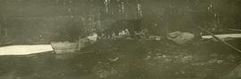
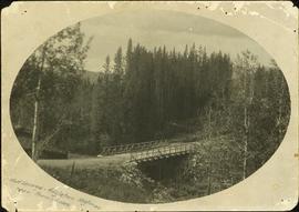
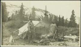
Showing 3808 results

Archival description
3546 results with digital objects Show results with digital objects
2009.5.3.32 · Item · [ca. 1913]
Part of Taylor-Baxter Family Photograph Collection

Photograph depicts two men standing in front of a short tent. Cooking supplies are scattered throughout campsite. Trees cross midground, and snow-covered mountains stand in background. Handwritten annotation on recto of photograph: "POTT FALLS ON REDDEER RIVER. A Plate of Beans before Lunch. ON THE RIGHT Bob - Potts. Sampling his own Cooking."

2009.5.3.43 · Item · [ca. 1913]
Part of Taylor-Baxter Family Photograph Collection

Photograph depicts group of men seated on scow carrying unidentified material. One man stands on rocky shore in left foreground, leaning on plank attached to scow. A second scow can be seen behind men. Tree-covered hills on opposite shore in background.

Bowron Canyon
2012.13.1.89.062 · Item · Sep. 1978
Part of J. Kent Sedgwick fonds

Image depicts what is possibly the Bowron River. The slide is simply labelled "Bowron Canyon."

Bowron Canyon - Log Jam
2012.13.1.89.063 · Item · Sep. 1978
Part of J. Kent Sedgwick fonds

Image depicts what appears to be a log jam on what is possibly the Bowron River. The slide is simply labelled "Bowron Canyon."

Bralorne
2012.13.1.059 · Subseries · 1980
Part of J. Kent Sedgwick fonds

File contains slides depicting locations in and around Bralorne, B.C.

Bralorne
2012.13.1.59.39 · Item · July 1980
Part of J. Kent Sedgwick fonds

Image depicts an area of Barlone, B.C. surrounded by trees.

2012.13.2.02.43 · File · 2006
Part of J. Kent Sedgwick fonds

File consists of maps and notes relating to the original Prince George city plans by Brett and Hall. Brett & Hall were landscape architects from Boston, MA who designed the original plan for Prince George, including features such as the Crescents neighbourhood. Includes photographs depicting the original plans by Brett & Hall for Prince George (2006).

Bridge
2012.13.1.45.15 · Item · 1983
Part of J. Kent Sedgwick fonds

Image depicts a bridge under construction in Tumbler Ridge, B.C.

Bridge and River
2012.13.1.45.20 · Item · 1983
Part of J. Kent Sedgwick fonds

Image depicts a river in Tumbler Ridge, B.C. The bridge crossing it appears to be either half-missing or incomplete.

Bridge Crossing River Canyon
2009.5.1.72 · Item · [ca. 1900]
Part of Taylor-Baxter Family Photograph Collection

Photograph depicts bridge built with wooden planks and poles, with triangles built into its frame. Water rapids in foreground, opposite shore in background behind bridge. This is speculated to be one of the bridges that crossed the Hagwilget Canyon on the Bulkey River since 1859, five kilometres from its confluence with the Skeena River. See items 2009.5.1.69 - 2009.5.1.71.

Bridge Near Burns Lake, BC
2009.5.1.90 · Item · [ca. 1915]
Part of Taylor-Baxter Family Photograph Collection

Photograph depicts a log bridge interrupting a wide dirt road in forest. Distant hills in background. Image has been cropped to an oval shape. Handwritten annotation on verso of photograph: "Fort George - Hazleton Highway Near Burn's Lake".

2008.3.1.22.12 · Item · [ca. 1995]
Part of Bridget Moran fonds

Bridget Moran stands on road, unidentified buildings behind on either side. Lake and hills on opposite shore in background. Photo believed to be taken at Metlakatla Lake, B.C. Building on left speculated to be the St. Paul's Anglican Church Learning Centre.

2008.3.4.4.3 · Item · 1946
Part of Bridget Moran fonds

Photograph depicts three women sitting on beach in their Women's Royal Canadian Naval Service uniform. Purses and shoes lay beside them, large rock stands in background. Handwritten annotation on recto of photograph: "The California 'Beauties' 1946." Left to right: Betty Pincombe (aka 'Chick'), Bridget Moran, and Grace Boice (aka Tommy).