1028 results with digital objects
Show results with digital objects
Stuk
Part of Cassiar Asbestos Corporation Ltd. fonds
Stuk
Part of Cassiar Asbestos Corporation Ltd. fonds
2000.1.1.1.06.02
·
Stuk
·
1966
Part of Cassiar Asbestos Corporation Ltd. fonds
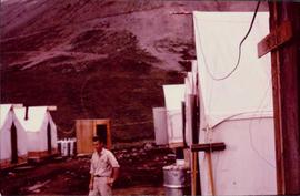
Photograph depicts man believed to be Matt Bell standing in Kutcho Creek exploration camp. The camp was set up by a crew led by Cassiar's Chief Geologist Bill Plumb. Tents on either side, wood structure in background. Sign on wood post: "PLUMB BLVD."
2000.1.1.1.06.04
·
Stuk
·
[1966?]
Part of Cassiar Asbestos Corporation Ltd. fonds
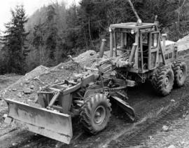
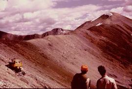
Photograph believed to have been taken near Kutcho Creek, BC during an outside exploration trip led by Cassiar's Chief Geologist Bill Plumb. Bill stands to left of man believed to be Matt Bell in right foreground. Bulldozer works along talus slope in left foreground.
2000.1.1.1.01.06
·
Stuk
·
[27 January 1951?]
Part of Cassiar Asbestos Corporation Ltd. fonds
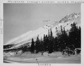
Photograph depicts the projected mining area of Asbestos Mountain, taken during the expedition of George Edzerza's party and their exploration of the future mine at Cassiar.
Handwritten annotations on verso in blue ink describing sections of photograph which have been pointed to or outlined in blue ink: "PROJECTED STRIKE - LOOKING NORTH - OVER -->" "<500'>" "NORTH".
Handwritten annotations in black ink on verso also outline areas and mark areas with "x".
Handwritten annotation on recto in blue ink: "No. 2. This is the continuation of the ore zone, over the top of the mountain, away from the 'fluff'' deposit."
Stuk
Part of Cassiar Asbestos Corporation Ltd. fonds
Stuk
Part of Cassiar Asbestos Corporation Ltd. fonds
Stuk
Part of Cassiar Asbestos Corporation Ltd. fonds
Stuk
Part of Cassiar Asbestos Corporation Ltd. fonds

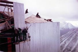
2000.1.1.2.04.01
·
Stuk
·
[ca. 1970]
Part of Cassiar Asbestos Corporation Ltd. fonds
Photograph depicts large square model of the new mill building that was built at the Cassiar plant site in 1970. Model is displayed on green material laid on floor against wall in unidentified room. Machinery modeled inside the structure is colour-coded.
Stuk
Part of Cassiar Asbestos Corporation Ltd. fonds
Stuk
Part of Cassiar Asbestos Corporation Ltd. fonds
Stuk
Part of Cassiar Asbestos Corporation Ltd. fonds
Stuk
Part of Cassiar Asbestos Corporation Ltd. fonds
Stuk
Part of Cassiar Asbestos Corporation Ltd. fonds
Stuk
Part of Cassiar Asbestos Corporation Ltd. fonds
Stuk
Part of Cassiar Asbestos Corporation Ltd. fonds
Stuk
Part of Cassiar Asbestos Corporation Ltd. fonds
Stuk
Part of Cassiar Asbestos Corporation Ltd. fonds
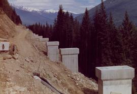
2000.1.1.3.07.03
·
Stuk
Part of Cassiar Asbestos Corporation Ltd. fonds
2000.1.1.3.07.05
·
Stuk
Part of Cassiar Asbestos Corporation Ltd. fonds
2000.1.1.3.07.09
·
Stuk
Part of Cassiar Asbestos Corporation Ltd. fonds
Stuk
Part of Cassiar Asbestos Corporation Ltd. fonds
Stuk
Part of Cassiar Asbestos Corporation Ltd. fonds
Stuk
Part of Cassiar Asbestos Corporation Ltd. fonds

2000.1.1.3.13.12
·
Stuk
·
25 October 1965
Part of Cassiar Asbestos Corporation Ltd. fonds
Photograph depicts large swath of dark waste down mountainside to right of valley. The waste dump is believed to be visible at top of swath on right of image. Bench mining visible on the North and South peak in background. Handwritten annotation on recto of photograph: "Oct. 25 / 65 4:25 PM."
2000.1.1.3.13.40
·
Stuk
·
1978
Part of Cassiar Asbestos Corporation Ltd. fonds
Photograph depicts the Cassiar mine, switchback road in foreground, mountain range in background. Pit is visible behind the West peak. The new mine garage can be seen on West peak just above "#7 switchback" in centre of image.
Stuk
Part of Cassiar Asbestos Corporation Ltd. fonds
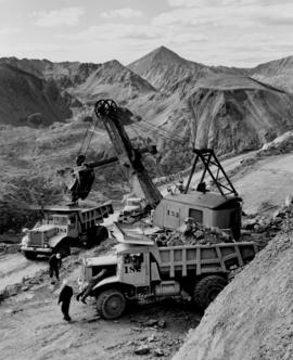
2000.1.1.3.15.15
·
Stuk
·
[ca. 1958]
Part of Cassiar Asbestos Corporation Ltd. fonds
Photograph depicts cable-operated shovel loading Kenworth haul truck on road in mine area at high elevation. Pickup truck in background, four unidentified men are gathered around second Kenworth truck in foreground. Valley and mountain range in distance.

2000.1.1.3.17.009
·
Stuk
·
1962
Part of Cassiar Asbestos Corporation Ltd. fonds
Photograph depicts tramline in a strip cleared of trees on McDame Mountain, bucket in foreground. Handwritten annotation on recto of photograph: "#2 SECTION LOOKING NORTH". Photograph was glued to cardboard backing with the annotation: "1962".

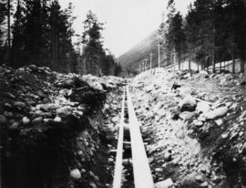
2000.1.1.3.19.002
·
Stuk
·
July 1961
Part of Cassiar Asbestos Corporation Ltd. fonds
Photograph depicts bench at 6430 elevation. Blasthole drills, shovels, dozers, and dump trucks can be seen on bench in midground. Mine valley in background. Handwritten annotation on verso of photograph: "1961".

2000.1.1.3.19.012
·
Stuk
·
1961
Part of Cassiar Asbestos Corporation Ltd. fonds
Photograph depicts a crawler cable shovel on right, and bulldozer partially visible on left. Rock face of mountainside in background. Handwritten annotation on verso of photograph: "1961", on recto: "Mining 80 D shovel on [?] 64/70 to 6560 saddle on peak."

2000.1.1.3.19.019
·
Stuk
·
1961
Part of Cassiar Asbestos Corporation Ltd. fonds
Photograph depicts dry rock storage building on left, mill in foreground, and tailings piles behind mill in midground. Mountains in background. Handwritten annotation on verso of photograph: "1961".
2000.1.1.3.19.020
·
Stuk
·
1961
Part of Cassiar Asbestos Corporation Ltd. fonds
Photograph depicts front of dry rock storage building, conveyor visible above on left. Handwritten annotation on verso of photograph: "1961".
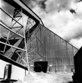
2000.1.1.3.19.024
·
Stuk
·
1961
Part of Cassiar Asbestos Corporation Ltd. fonds
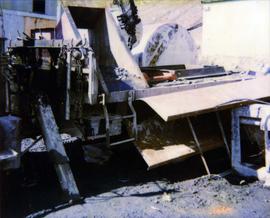
Photograph depicts a man wearing a hard hat standing at what is believed to be the dust collection system in the Cassiar mill. Sign on right reads "CAUTION NO WELDING, BURNING OR SMOKING IN THIS AREA." Handwritten annotation on verso of photograph: "1961".
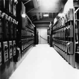
2000.1.1.3.19.027
·
Stuk
·
1961
Part of Cassiar Asbestos Corporation Ltd. fonds
Photograph depicts hallway in power house building. Handwritten annotation on verso of photograph: "1961".
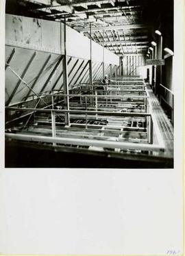
2000.1.1.3.19.028
·
Stuk
·
1961
Part of Cassiar Asbestos Corporation Ltd. fonds
Photograph depicts woman in white lab coat testing quality of asbestos fibre. Special lab instruments sit on counter top. Handwritten annotation on verso of photograph: "1961".
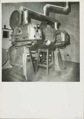
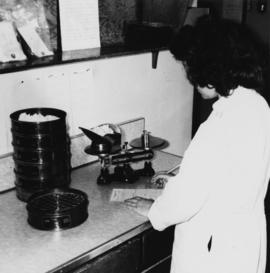
2000.1.1.3.19.029
·
Stuk
·
1961
Part of Cassiar Asbestos Corporation Ltd. fonds
Photograph depicts man seated on stool between two carbon arc Horton movie projectors. These were 16 mm French projectors, and were located at the Cassiar Recreational Center. They were used before the new movie theater was built in the late 1970s. Handwritten annotation on verso of photograph: "1961".
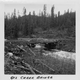
2000.1.1.1.02.06
·
Stuk
·
[June 1951?]
Part of Cassiar Asbestos Corporation Ltd. fonds
Photograph depicts a log bridge across Quartz Creek taken from shore. Trees in background on opposite shore, snow capped mountains barely visible behind trees.
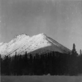
2000.1.1.1.03.05
·
Stuk
·
27 December 1951
Part of Cassiar Asbestos Corporation Ltd. fonds
Photograph depicts McDame Mountain from view of the early construction campsite at Cassiar. Trees in foreground.
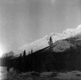
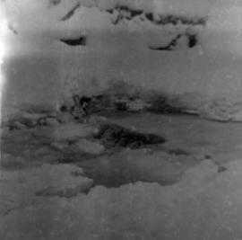
2000.1.1.1.03.06
·
Stuk
·
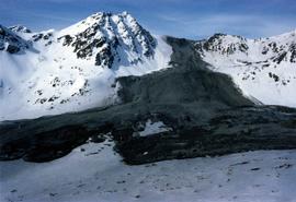
24 December 1951
Part of Cassiar Asbestos Corporation Ltd. fonds
Photograph depicts glacier on McDame Creek road, 1.5 miles from the mine at Cassiar. Snow-covered trees in background.
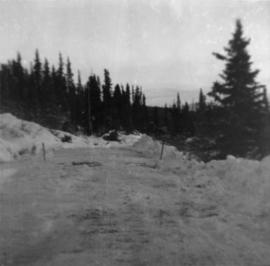
2000.1.1.1.03.09
·
Stuk
·
24 December 1951
Part of Cassiar Asbestos Corporation Ltd. fonds
Photograph depicts McDame Creek Road, snow-covered and taken from center of road 1.5 miles from the early construction camp at Cassiar. Two stakes in foreground, one on either side of road. Glacier is believed to be crossing road between two stakes. Trees on either side of road, trees and hills in background.
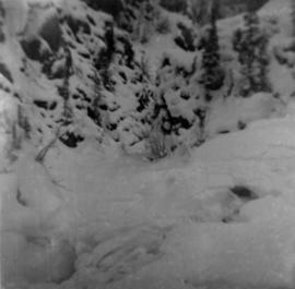
2000.1.1.1.03.10
·
Stuk
·
22 Demember 1951
Part of Cassiar Asbestos Corporation Ltd. fonds
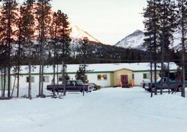
Photograph depicts snow-covered mountain north of townsite, partially covered in shadow. Photo taken with sun at highest point in the sky. Plant site clearing in foreground, trees behind clearing.
2000.1.1.1.03.14
·
Stuk
·
28 December 1951
Part of Cassiar Asbestos Corporation Ltd. fonds
Photograph depicts weir on Troutline Creek, snow in foreground and background.