File contains original copy of the 1957 - 1967 working plan for the Aleza Lake Research Forest.
File contains typed file notes and charts of remeasured experimental plots, as well as a floppy disk
File contains information, including diagrams, measurement charts, and a map, for experimental plot 119.
File contains information, including diagrams, measurement charts, and a map, for experimental plot 148.
File contains information, including diagrams, measurement charts, and a map, for experimental plot 291.
Map of Timber Sale X9696 shows the area for the TSX with spruce balsam timber. Location is 4 miles from the Myra Station of the Kettle Valley Railway.
Item is a reproduced map of Aleza Lake annotated to show a 1994 RFP study area.
Item is a photocopied Aleza Lake Forest map with forest cover labels annotated to show 1994 RFP study area.
Map depicts central British Columbia including Prince George, Queen Charlotte Island, Prince of Wales Island, Prince Rupert, and describes what these areas are known for.
The map depicts the biotic regions and forests in British Columbia.
The map is split into four time periods of colonial exploration. The map depicts pre-colonial, post-colonial, traditional, and colonial expansion.
This map depicts where to find ghost towns, forts, First Nation villages, and sites with supposed hidden treasures in British Columbia.
Subseries reflects Dr. Ainley's extensive research on indigenous science and traditional knowledge and how it transferred to European settlers in Canada, Australia, and New Zealand. Much of this research culminated in Dr. Ainley's unfinished monograph project "Re-explorations: new perspectives on gender, environment and the transfer of knowledge in 19th and 20th century Canada and Australia." Material is, predominately, arranged by individual, with files largely consisting of bibliographies, articles and notes about and by the individual on topics related to the environment and interaction with indigenous peoples. Subseries also contains research notes, interviews, and correspondence. As much of Ainley's research focused on women, see subseries on women in science and engineering research (2002.14.1.5) for related materials.
Collection consists of materials related to Fort George surveying and preemption, including both legal and personal correspondence, legal documents and records, plans of lots, photographs, and a map. Includes records from the Cariboo Investment Company, Ltd., J.B. Henderson-Roe and C.H. Henderson Roe.
Map is a "Recreation and Logging Road Guide to the Forest Lands of Vancouver Island Alberni Valley and the Surrounding Area" created for the public. Backside states "Welcome to TFL 44", along with promotional imagery and information for backcountry travelers.
This fonds consits of the administrative and business papers of Mr. Adam Zimmerman during his tenure as a senior level executive with Noranda Inc., Noranda Mines Ltd, and Macmillan Bloedel Ltd., particularly in Ontario, Quebec, and British Columbia with the majority of these records relating to the senior level operations of these companies. It includes textual records relate to the creation and development of Northwood Pulp & Timber Ltd. in Prince George including all aspects of its regional operations throughout Northcentral BC). The fonds also includes records related to Noranda Inc.’s successful and unsuccessful attempts at business acquisitions in both forestry and mining operations internationally, particularly in Mexico, Brazil, the Netherlands and Tasmania.
The fonds also contains textual records generated by Zimmerman in his directorship and chairman positions on various forest industry association boards. It includes his notes, general correspondence, minutes, as well as booklets and brochures notably from the Canadian Forest Industries Council, the Canadian Pulp and Paper Association, the Forest Sector Advisory Council and other similar industry associations. Much of this material relates to the issue of the softwood lumber dispute and Zimmerman’s involvement in the lobbying efforts regarding Canada/U.S. Free Trade issues and includes bound reports, agreements, and publications as well as correspondence to/from Zimmerman and his handwritten notes within the files. The fonds also includes general business information (annual reports, brochures, publications) pertaining to other Canadian forestry and mining companies.
The fonds also contains Adam Zimmerman’s speeches and correspondence related to his involvement in numerous charities, foundations and corporate fundraising initiatives with numerous Canadian educational institutions, non-profit societies and federal election campaigns.
Business records of Noranda Inc. are extensive and include administrative, business, personnel, financial and legal records. Record types include correspondence, memos, handwritten notes, business proposals and meeting notes, merger proposals and notes, prospectuses, board meeting agendas and minutes, annual reports, financial statements, resumes, portfolios, printed brochures, publications and other ephemera related to the business operations of Noranda Inc., Noranda Mines and MacMillan Bloedel [during Noranda Mines take-over of MB] all during Zimmerman’s tenure as Chair and/or CEO. The fonds includes correspondence, financial reports, legal testimony transcripts resulting from the Gaspe Copper Mine labour strike in Quebec in 1957 and the subsequent Gaspe Law Suit of 1960 between Noranda and the United Steel Workers of America. The fonds also includes extensive correspondence between Zimmerman and various levels of government regarding the lobbying of government on forestry policy and correspondence with various environmental lobbying groups in the 1980s including correspondence with well-known environmentalist David Suzuki.
Subjects include all facets of business operations pertaining to Canadian forestry and mining sectors including labour issues, environmental impacts of industrial developments, industry and effects on the Canadian economy, the free trade debate, the softwood lumber issue etc.
The fonds provides a detailed archival record of Mr. Zimmerman’s contribution to the building of Noranda Forest in Canada, Northwood Pulp & Timber in BC and Noranda Inc. as a resource-based conglomerate. Many records were utilized by Mr. Zimmerman in the writing of his book, Who’s in Charge Here, Anyway?: reflections from a life in business, (Don Mills, Ontario: Stoddart; Distributed in Canada by General Distribution Services), 1997.
Zimmerman, AdamThis file consists of 10 photographs pertaining to the Hixon Creek Cariboo Gold Company, and the Quesnel Quartz Mine; as well as two sheets of letterhead from the "Hixon Gold Recovery Ltd." a handwritten speech re: a mineral claim, and a hand drawn map and overlay pertaining to the Wellington and Highland (Belle or Lass) mineral claims.
Maps within this series document the placer streams, islands and harbours of the Queen Charlotte Islands; as well as the mining properties located within the vicinity of Stewart, BC.
Map depicts the City of Prince George in 1976, including the Fraser River, Nechacko River, Cariboo Highway, Carney St., and Patricia Blvd. where the electoral district boundary was proposed along for the two districts of Fort Nelson-Peace River and Prince George-Bulkley Valley.
Map depicts the city of Victoria and the electoral districts of Esquimat-Saanich, Victoria and Cowichan-Malahat-The Islands.
Map depicts the city of Vancouver, including the electoral districts of Comox-Powell River, Capilano, North Vancouver-Burnaby, Mission-Port Moody, Burnaby, Fraser Valley West, New Westminster-Coquitlam, Surrey-White Rock-North Delta, Richmond-South Delta, Vancouver South, Vancouver Kingsway, Vancouver Quadra, Vancouver Centre, and Vancouver East.
Map depicts Western Canada and annotations highlight the prospective members and the member centres of the Yellowhead Interprovincial Highway Association.
Map includes an annotated line indicating the city limits and the crown land surrounding the village of Kitimat.
Government map depicts railway lands, lands "disposed of", grazing leases, and timber berths. Shows the British Columbia 'railway belt' running from Greater Vancouver to Field, B.C.
Map depicts all current rail lines in Western Canada and Alaska and major railway stations. Includes insets for Alaska & Yukon, Edmonton area, Winnipeg area, and the Vancouver area.
Map depicts the Abbotsford area, including railway lines.
Map depicts rail trackage in the Greater Vancouver area, showing dates of completion and abandonment of railway lines. Also shows proposed rail lines.
Map depicts the city of Richmond and Lulu Island, including rail trackage.
Tourist map of Prince George depicts city area, with annotations by Davies to emphasize locations of rail lines.
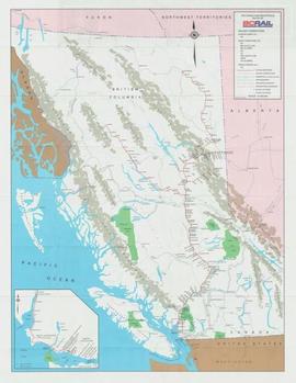
Map depicts the route of BC Rail and its connecting rail lines.
Map depicts area around Kelowna, with annotated Kettle Valley Railway Carmi subdivision line, Hydraulic Lake, and McCulloch.
Map depicts the cities of Summerland, Penticton, and Naramata. Annotated by Davies to emphasize the rail lines in the area.
Map depicts the City of Squamish, Howe Sound, and the Britannia Mine.
Subseries consists of materials collected by Kent Sedgwick for research relating to Lheidli T'enneh First Nations. The Lheidli T'enneh are a sub-group of the Dakelh people whose traditional territory includes the city of Prince George, British Columbia. These files primarily consist of material regarding the original Lheidli T'enneh reserve and cemetery, the reserve relocation, and the desecration of the cemetery.
File consists of notes, clippings, and reproductions relating to Indigenous Peoples of British Columbia. Includes: "A selected list of publications on the Indians of British Columbia" published by the British Columbia Provincial Museum (1970) and "Les Indiens Des Cordilleres" printed by the National Museum of Canada (7 Feb. 1939). File also includes a map titled "Native Lands, then and now" depicting British Columbia including outlines of Indigenous territories and a smaller map of Canada with Indigenous language families; the backside of the map is titled "What are you ready for" and includes a timeline of information and Indigenous history in British Columbia (1990).
The map depicts British Columbia, including outlines of Indigenous tribal territories and a smaller map of Canada with Indigenous language families. The reverse side of the map is titled, "What Are You Ready For" and includes a timeline of information and Indigenous history.
The item is a reproduction of an aerial photograph of Prince George. Annotation states, "City of Pr. Geo. 1958 Aereal Photo CBD."
Map depicts to Canadian federal electoral districts for the 1993 federal election.
File consists of notes, reproductions, and letters relating to the street names in Prince George. Includes: "Canadian Permanent Committee on Geographical Names" typescript document; email from Ramona Rose to Kent Sedgwick (8 Dec. 2000); "Future entrance sign on Tyner Boulevard" typescript letter to Mr. Hamer from Ruth Iversen (10 Jan. 1995); "South Fort George gardens plan of subdivision" reproduced map depicting subdivision lots along the Fraser River in Prince George (2011); and "Porter Creek" letter from the Province of British Columbia to Kent Sedgwick (16 May 1989).
The item is a reproduction of a section of survey map drafted on 18 March 1915 and revised on 23 May 1916. The reproduction was likely created in 1990. The Plan Number is 1268 and highlights the area along the Nechako and Fraser Rivers. The map details subdivisions East of Carney Street, North of Twentieth Avenue and South of Ninth Avenue. Annotations in pencil state different map scale variations and "cemetery setback."
The item is a reproduction of a section of survey map drafted in 1915. The reproduction was likely created in 1990. The Plan Number is 1268 and highlights the area along the Nechako River. The map details subdivisions East of Carney Street and North of Fifth Avenue. Some original street and avenue names have been crossed out and replaced with handwritten names. Annotation on reverse side of map states, "D.L. 343 Pl. 1268."


