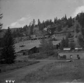
Photograph depicts Moyie Lake, 15 miles south of Cranbrook, and Moyie Station. The tailings are from a lead and zinc mine directly to the right of the photograph on the hillside. The view is looking north.
Photograph depicts a 10 ton Wallis & Stevens Ltd. #7985 steam roller. It was built at Basingstoke, England from about 1925 to 1927. It is located at 6110 Curtis St. in Burnaby, BC
Photograph depicts a C.P.R. wrecking train unit at Vancouver station.
Photograph depicts a general view, looking north, of Westview Harbour with the Powell River paper plant smoking in the background.
Photograph depicts the newsprint plant of MacMillan, Bloedell, and Powell River Ltd. In Powell River, B.C. The view is looking northwards and shows that the plant is working on Easter Day/
Photograph depicts a steam crane in a lumber yard on the north side of Porpoise Bay in Sechelt on the Sechelt Peninsula. The steam crane has been converted to diesel and was made by the Brown Hoisting Co. from Cleveland, Ohio. It lifts 21 tons at a 12ft radius and 5 tons at 35ft radius, and is in daily use. The 200 yards of rail track form a "Y" with the bottom piece onto the wharf.
Photograph depicts a once used booming boat made of log sections at a log dump on seashore about 5 miles north of Powell River, and opposite Harwood Island. Stern at left with prop guard.
Photograph depicts a log dump on seashore about 5 miles north of Powell River and opposite Hardwood Island. The view is looking north.
Photograph depicts a logging bridge over Lois River between Saltery Bay and Lang bay, south of Powell River.
Photograph depicts a lumber yard on the north side of Porpoise Bay in Sechelt on the Sechelt Peninsula. The tank in the photograph is about 8 to 10 feet in diameter.
Photograph depicts logging on a side road on the Sechelt Peninsula about 2 miles southeast of Halfmoon Bay.
Photograph depicts the Hedley Gold Mine, 26 miles east of Princeton. Crusher workings.
Item is a photograph of officials attending the June opening of the Crestwood Forest Industries pulp mill in Cranbrook, until that time the only pulp mill built without benefit of a Pulp Harvesting Area (PHA) license to assure timber supply. Mr. Williston is on the left.
Photograph of Prime Minster Pierre Trudeau standing with a group of men looking over the Cassiar valley. Trudeau stands in the middle wearing a yellow shirt.
Photograph depicts Trudeau wearing a white hardhat with his name on the front.
Photograph depicts Trudeau standing outside with a group of men.
Photograph depicts Trudeau standing by trees and brush with a group of men on his Cassiar tour.
Photograph of Prime Minster Pierre Trudeau standing with two other men at the Cassiar Mine.
Photograph depicts an unknown woman kissing Trudeau on the cheek in a crowd of people.
Photograph depicts Trudeau walking outside with a group of men and women on his tour of the Cassiar operation.
Photograph depicts Trudeau being shown the Cassiar mine from outside by Cassiar employees
Photograph depicts Trudeau standing outdoors with three unknown RCMP constables. Cassiar valley is in the background.
Photograph depicts Trudeau standing outdoors and speaking with an unknown man.
Photograph depicts the inside of a mill.
Image depicts a Hydraulic Placer mining location in Barkerville which has been completely deforested.
Photograph of the Mill Modification program in 1970. This photo is part of larger collection of 71 photographs of regarding the improvements to the mill as part of the plantsite and was compiled into a report in 1978.
Photograph depicts a safety sign in a mill work area that reads, "You can bet your life on safety."
Photograph depicts a work area in a mill.
Photograph depicts a work area in a mill with danger signs in English, French, German, and Spanish.
Photograph depicts the inside of a mill.
Photograph of two workers in background working on the Mill Modification program in 1970. This photo is part of larger collection of 71 photographs of this program, compiled into a report in 1978.
Photograph depicts the inside of a mill.
Photograph depicts flowing water believed to be Troutline Creek which ran south of Cassiar, B.C. Tailings pile and plant buildings visible behind forest in midground, northern mountain range in background. Handwritten annotation on verso of photograph: "Cassiar June 15 71".
Photograph depicts fenced church building with what appears to be speakers mounted on roof above main entry. Road and trees in foreground, mountains in background. Handwritten annotation on verso of photograph: "Cassiar June 15 71".
Photograph depicts part of a brown and white building similar to the "Director's Lodge" at Cassiar, B.C. (see items 2000.1.1.3.19.88 and 2000.1.1.3.19.89). Unidentified individuals visible inside greenhouse in fenced back yard. Forest in background. Handwritten annotation on verso of photograph: "Cassiar June 15 71".
Photograph depicts three women wearing matching attire in doorway of CP Air plane on runway. Small plane in foreground, field and trees in background. Handwritten annotation on verso of photograph: "Watson Lake June 14 71".
Photograph depicts two lawn chairs in front of building with front deck. Trees visible in foreground and background. Handwritten annotation on verso of photograph: "Directors Lodge Cassiar June 15 71". Building also known as "House 130".
Map depicts location of treasure hidden between Clearwater and Clemina, BC.
Photograph depicts long bunkhouse buildings located between the Cassiar plant and townsite. They were originally used seasonally by university students, or by new employees on waiting lists for the more accommodating panabode "Winter Bunkhouses" (see item 2000.1.1.3.19.113). These buildings are speculated to be bunkhouses number 86, 87, and 88. Trees cross midground; new mill building, tailings pile, and mountains visible in background. Handwritten annotation on verso of photograph: "Cassiar June 15 71".
Photograph depicts tramline buckets and tower on plantsite. Vehicles, building materials, and unidentified buildings also visible on plantsite (including what appears to be a water tower). Mountains and valley in background. Handwritten annotation on verso of photograph: "Cassiar June 15 71".
Photograph depicts two-story yellow and orange office building. Unidentified individual stands with garden hose in foreground near what appears to be a lawnmower. Warehouse semi-visible in left background; blue truck and new mill building visible in right background. Handwritten annotation on verso of photograph: "Cassiar Office June 15 71".
Photograph depicts two unidentified men on front deck of building behind trees. Road and car in foreground, mountains visible in background. Handwritten annotation on verso of photograph: "Directors Lodge Cassiar June 15 71". Building also known as "House 130".
Photograph depicts brown and white building similar to the "Director's Lodge" at Cassiar, B.C. (see items 2000.1.1.3.19.88 and 2000.1.1.3.19.89). Station wagon parked in driveway behind short fence in foreground. Trees in foreground, forest and mountains visible in background. Handwritten annotation on verso of photograph: "Cassiar June 15 71".
Map depicts the routes of the Pacific Great Eastern Railway, showing stations, railway connection, and the PGE Microwave Communication System.
Image depicts a group of people at a mine somewhere near Hazelton, B.C.
Item is a photograph of a fishing boat with the net deployed with other boats and people on shore.
Item is a photograph of a boat under construction.
Item is a photograph of a man operating a piece of wood cutting machinery.
Image depicts an 80 tonne truck at a mine site somewhere in Granisle, B.C.