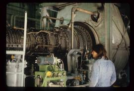
Image depicts what is possibly the Alcan smelter in Kitimat, B.C.
Image depicts the Alcan smelter in Kitimat, B.C.
Image depicts a small model of the old prospecting process in what is likely Barkerville, B.C.
Image depicts a Hydraulic Placer mining location in Barkerville which has been completely deforested.
Image depicts the old sales office of Bralorne Pioneer Mines Ltd. which is now the Bralorne Pioneer Museum.
Image depicts what is possibly an old, rundown mill in Bralorne, B.C.
Image depicts the Lajoie hydroelectric generating station at the Lajoie Dam on the Bridge River (view of powerhouse and tailrace from top of dam).
Image depicts the Bridge River No. 1 hydroelectric station on the shore of Seton Lake (rear side of powerhouse).
Image depicts a river full of logs, somewhere near Bralorne, B.C.
Image depicts a piece of industrial machinery, possibly located at the closed Britannia Mine. Two unknown individuals are also present in the image.
Image depicts a conveyor belt, possibly located inside one of the old buildings at what is possibly the closed Britannia Mine.
Image depicts a number of old buildings, possibly located at the closed Britannia Mine.
Image depicts the inside of a mine with an unknown individual present. It is possibly the inside of the closed Britannia Mine.
Image depicts the entrance to a mine with an unknown individual present. It is possibly the entrance to the closed Britannia Mine in the Howe Sound Region.
Image depicts the Britannia Mine, which closed in 1974 and is now a museum. "Anaconda" was the last operating owner.
Image depicts an 80 tonne truck at a mine site somewhere in Granisle, B.C.
Image depicts numerous bags of blasting powder at a mine site somewhere in Granisle, B.C.
Image depicts a large, electric shovel at a mine site somewhere in Granisle, B.C.
Image depicts a drill for blasting holes at a mine site somewhere in Granisle, B.C.
Image depicts a group of people at a mine somewhere near Hazelton, B.C.
Image depicts what appears to be a sawmill at 100 Mile House, B.C.
Image depicts a sawmill somewhere in Quesnel, B.C.
Image depicts numerous wood piles near the sawmill somewhere in Quesnel, B.C.
Image depicts a sawmill somewhere in Quesnel, B.C.
Image depicts the interior of the Gibraltar chemical mill, where they separate the molybdenum.
Image depicts an unknown woman standing in front of a truck that either weighs 80 tonnes, or is capable of carrying that much; the slide is simply labelled "80 tons." It is located at the Gibraltar mine site.
Image depicts an open mining pit at an uncertain location; it is possibly Gibraltar.
Image depicts an aerial view of the Gibraltar mine site's pits and waste dumps, north of Williams Lake, B.C.
Image depicts the BCR tracks passing through a mill somewhere near the 100 Mile.
Image depicts what is likely the Dunkley Lumber Mill in Strathnaver, B.C.
Image depicts the BCR, as well as the Dunkley Lumber Mill, in Strathnaver, B.C.
Image depicts a view of the Dunkley Lumber Mill in Strathnaver, B.C.
Image depicts a number of workers putting in blasting powder at the Gibraltar mine site north of Williams Lake, B.C.
Image depicts a loading truck at the Gibraltar mine site north of Williams Lake, B.C.
Image depicts an 80 tonne truck full of rocks at the Gibraltar mine site north of Williams Lake, B.C.
Image depicts the Gibraltar mine site north of Williams Lake, B.C.
Image depicts a the Danson Industrial Park in Prince George, B.C.
Image depicts a sawmill in the Danson Industrial Park in Prince George, B.C.
Image depicts the Carter Industrial Area in Prince George, B.C.
Image depicts Prince George from University Way, with the P.G.I pulp mill in the distance.
Image depicts Prince George from University Way, with the P.G.I. Pulp Mill in the distance.
Image depicts two mills; the Intercontinental Pulp Mill is on the right in the foreground, and the Prince George Pulp and Paper Mill is on the left in the background. The picture is taken from the South, possibly off Yellowhead Bridge in Prince George, B.C.
Image depicts two mills; the Intercontinental Pulpmill is on the left side of the tracks in the image and the Prince George Pulp and Paper Mill is located on the right side in Prince George, B.C. The Northwood Pulp Mill can be seen in the distance.
Image depicts a piece of industrial machinery in an uncertain location near McLeod Lake, B.C.