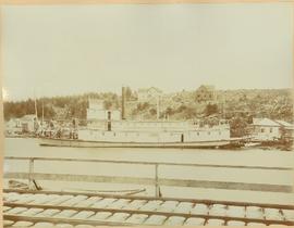
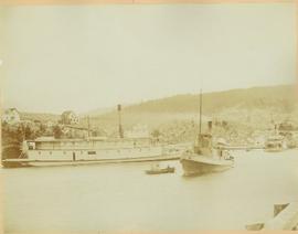
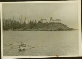
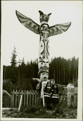
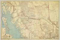
Mostrando 3619 resultados

Archival description
View of Fort Wrangell, Alaska
2006.45.17 · Item · [ca. 1897]
Parte de Historical North Coast Photograph Album

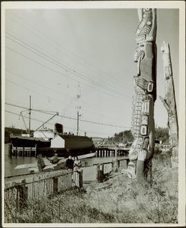
View of town on shore, from above. Boats docked along piers and buildings. Hills visible on either side of water in background.

Handwritten photo captions with arrows pointing to sections of image read: "General Merchandise", "Fort Wrangell Hotel".

Port Simpson, BC
2006.45.2 · Item · [ca. 1897]
Parte de Historical North Coast Photograph Album

Photograph depicts Port Simpson in winter. Water and shoreline in foreground, hill in distance.

Handwritten photo caption below image reads: "Port Simpson".

River Boats at Port Simpson, BC
2006.45.7 · Item · [ca. 1897]
Parte de Historical North Coast Photograph Album

Photograph depicts sternwheeler, smaller boat, and canoe in foreground. Second sternwheeler named the 'Caledonia' can be seen anchored to shore in background. Town buildings stand on hill in background. Photo believed to have been taken in Port Simpson, B.C.

2007.17.2.3 · Item · [ca. 1964]
Parte de James Joseph Claxton Photograph Collection

Photograph depicts two unidentified, young First Nations girls standing hand in hand on a rocky beach. Rail tracks extending from the water to the shore are visible in the lower right corner and in the background. Handwritten annotation on verso reads: “Kingcome Reserve”

2007.17.4.22 · Item · [ca. 1960]
Parte de James Joseph Claxton Photograph Collection

Photograph depicts a woman wearing a Cowichan sweater rowing a boat away from a rocky island with a lighthouse. Handwritten annotation in pencil on verso reads: “Gal in boat wearing Indian sweater knit by my mother Eileen M. Jackson (she also spun the wool) for her brother J.J. Claxton, cook on the Columbia Coast Mission Boat. - S.K. Jackson”

Memorial Pole for Tlaqwa Latle
2007.17.6.10 · Item · [ca. 1960]
Parte de James Joseph Claxton Photograph Collection

Photograph depicts a memorial totem pole in front of a fence line and a forested environment. Inscription on memorial pole states: “In loving memory of Tlaqwa Latle of the Qidwasudinuk Tribe, Died Nov. 9 - ” Photographer’s stamp on verso: “W.E. Nicholson, 268 E. 10th, Vancouver 10, B.C.”

2007.17.6.11 · Item · [ca. 1960]
Parte de James Joseph Claxton Photograph Collection

Photograph depicts a man in uniform and a woman posing for a photo on a road situated between a fenced area featuring totem poles. Along the water’s edge in the background there is a float plane, wharf and the Camosun vessel. Handwritten annotation on verso reads: “Alert Bay B.C. Union Steamships Ltd.”; “Alert Bay BC”; photographer’s stamp on verso states: “W.E. Nicholson, 268 E. 10th, Vancouver 10, B.C.”

Totem pole standing amongst the trees
2007.17.6.2 · Item · [ca. 1960]
Parte de James Joseph Claxton Photograph Collection

Photograph depicts a totem pole standing amidst a forested environment. Handwritten annotations on verso read: “Raven, ?, Sea Lions, Grizzly Bear, Dzondgwa”; “Kwakiutl Pole, Alert Bay & Fort Rupert” photographer’s stamp on verso: “W.E. Nicholson, 268 E. 10th, Vancouver 10, B.C.”

Pre-Emptor’s Map, Fort George Sheet
2008.2.1.02 · Item · 1916
Parte de Northern BC Cartographic Collection

Colour-coded map depicting lands open for pre-emption, lands in “University Reserve,” and lands reserved for public auction. Depicts land recording divisions, communities, bodies of water, transport routes, and game reserves.

Pre-Emptor’s Map, Fort George Sheet
2008.2.1.08 · Item · 15 February 1923
Parte de Northern BC Cartographic Collection

Colour-coded map depicting lands surveyed as alienated, reserved, Statutory Timber Lands, B.C. Land Settlement Board Area, or open for pre-emption. Depicts land districts, land recording divisions, communities, game reserves, bodies of water, transport routes, and communication lines.

Pre-Emptor’s Map, Stuart Lake Sheet
2008.2.1.09 · Item · 1 December 1923
Parte de Northern BC Cartographic Collection

Colour-coded topographic map depicting lands surveyed as alienated, reserved, or statutory timber land. Depicts land district boundaries, land recording divisions, HBC posts, triangulation stations, telephone lines, communities, bodies of water, and transport routes. Defines resource type areas (“Land Form,” “Soil,” “Forest Cover,” “Grazing,” “Geological & Mineralogical,” “Fur-Bearing Animals & Game”). Includes explanatory “Natural Resources Reference.”

Preliminary Map, Grenville Channel
2008.2.1.10 · Item · 1924
Parte de Northern BC Cartographic Collection

Colour-coded map depicting lands surveyed as alienated, reserved, and having a timber license, lease, or sale. Depicts land recording divisions, land district boundaries, communities, bodies of water, and transport routes. Includes insets of Stephens Island and Egeria Reach.

Pre-Emptor’s Map, Nechako Sheet
2008.2.1.13 · Item · 1926
Parte de Northern BC Cartographic Collection

Colour-coded map depicting surveyed lands alienated, reserved, in B.C. Land Settlement Board Area, or open for preemption. Depicts land districts, land recording divisions, communities, bodies of water, transport routes, and communication lines.

Pre-Emptor’s Map, Peace River Sheet
2008.2.1.14 · Item · 1 February 1928
Parte de Northern BC Cartographic Collection

Colour-coded topographic map depicting lands surveyed as alienated, reserved, or open to preemption. Depicts land districts, land recording divisions, communities, bodies of water, communication lines, and transport routes.

Pre-Emptor’s Map, Prince Rupert Sheet
2008.2.1.15 · Item · 1929
Parte de Northern BC Cartographic Collection

Colour-coded map depicting surveyed lands respectively open and closed to preemption. Depicts land recording divisions, land district boundaries, government reserves, communities, bodies of water, and transport routes. Includes topographical inset.

Northern British Columbia
2008.2.1.18 · Item · 1 May 1933
Parte de Northern BC Cartographic Collection

Regional map depicting communities, parks, customs posts, airports, radio stations, hatcheries, bodies of water, transport routes, communication lines, elevation points, and lines of batholith contacts. Includes an inset of St. Elias Mountains. Includes “Special Note on the Mineralization of this Map Area” from Bureau of Mines, Victoria, B.C.

Bulkley Sheet
2008.2.1.20 · Item · 1937
Parte de Northern BC Cartographic Collection

Colour-coded map depicts lands surveyed as alienated, available for purchase or lease under Taxation Act, or reserved. Depicts land district boundaries, land recording divisions, triangulation stations, telegraph/telephone lines, communities, bodies of water, and transport routes.

Central British Columbia
2008.2.1.21 · Item · 1 May 1940
Parte de Northern BC Cartographic Collection

Topographic map depicts communities, bodies of water, transport routes, parks, game reserves, posts, ports, radio stations, power sites (figures in horse power), steamship routes (distance in nautical miles), and precipitation. Mineral resources summarized locally in red ink.

Stuart Lake Sheet
2008.2.1.22 · Item · 1 August 1940
Parte de Northern BC Cartographic Collection

Colour-coded topographic map depicting lands surveyed as alienated, available for purchase or lease under Land Act, or reserved. Depicts land district boundaries, land recording divisions, provincial forest boundaries, HBC posts, triangulation stations, telephone lines, communities, bodies of water, and transport routes.

Nechako Sheet
2008.2.1.23 · Item · 1 December 1942
Parte de Northern BC Cartographic Collection

Colour-coded topographic map depicts surveyed lands alienated, available for purchase or lease under Land Act, and available for pre-emption. Depicts land districts, land recording districts, provincial forests, parks, triangulation stations, communities, bodies of water, transport routes, and communication lines.

Fort George
2008.2.1.24 · Item · 3 January 1944
Parte de Northern BC Cartographic Collection

Colour-coded map depicting surveyed lands alienated, available for purchase or lease under Land Act, and available for pre-emption. Depicts land districts, land recording districts, provincial forests, parks, game reserves, communities, bodies of water, transport routes, communication lines, and triangulation stations.

Peace River
2008.2.1.25 · Item · 2 January 1945
Parte de Northern BC Cartographic Collection

Colour-coded topographic map depicting surveyed lands alienated, available for purchase or lease, or available for pre-emption. Depicts land districts, land recording districts, parks, communities, bodies of water, transport routes, communication lines, and triangulation stations.

Fort George
2008.2.1.27 · Item · 1 May 1949
Parte de Northern BC Cartographic Collection

Colour-coded map depicts surveyed lands alienated, available for purchase or lease under Land Act, or available for pre-emption. Depicts land districts, land recording districts, provincial forests, parks, game reserves, communities, bodies of water, transport routes, communication lines, triangulation stations, and government reserves.

2008.27.3 · Dossiê · 1935-1997
Parte de Knox McCusker Collection

File consists of the following items:

  • "Mac" by D.L. Surveyor
  • "Knox (Mac) McCusker: Dominion Land Surveyor" by E.L. Rutherford, V.C. Brink, R.S. Silver and M.Z. (Smokey) Neighbour
  • Excerpts from Men and Meridians by Don W. Thomson
  • Article re: Knox McCusker written on the occasion of his death (April 14, 1955)
  • "McKusker (sic) to open up Blueberry Mountain Area" (Alaska Highway News, June 8, 1950)
  • "McCusker was surveyor, big game guide….also rancher and trail blazer"
  • "Knox Freeman McCusker" written on the occasion of his death (The Canadian Surveyor, July 1955)
  • "Veteran Surveyor - Alaska Highway Stories"
  • Memories of Knox McCusker by his oldest niece Betty (McCusker) Rutherford
  • "Veteran Surveyor prefers horses for long bush treks" by Eric Young (Edmonton Journal)
  • Eulogy for Knox McCusker read by Stanley D. Seif at Burch Presbyterian Church in Fort St. John, B.C.
  • Eulogy for Gwendolyn Dorothy McCusker (July 1997)
  • "Tropical Valley No Myth: amazing story of woman who lived there" by Thomas A. Wayling (Vancouver Sun)
  • Photocopy of section of map: "Topographical sketch map showing route traversed by the Bedaux Sub-Arctic Expedition 1934 through the Rocky Mountains" (by Frank Swannell, March 27, 1935)
  • Memories of Knox McCusker by Bill McCusker, his oldest nephew
  • "There is always a reason; destiny made it a date. The corridor of the Alcan didn’t just happen" (Fort St. John publication)
  • Article on Knox McCusker (ALS News, Winter 1983)
2008.27.4 · Dossiê · 1998-2003
Parte de Knox McCusker Collection

File consists of the following materials:

  • Letter to Vernon C. Brink from the National Archives of Canada re: Knox McCusker holdings (March 1, 1999)
  • Photocopy of article: "Living Landscapes: Exploring the wilds of northeaster BC" by Ross Peck and Brian Apland
  • Some materials for an article on Knox McCusker, D.L.S.
  • Material about the life of Knox Freeman McCusker
  • Letter to Mrs. Rutherford (Oct. 5, 1999) re: access to interview of Knox McCusker by Frank Willis
  • Accession information print-out re: interview of Knox McCusker by Frank Willis in 1954
  • National Archives of Canada accession information print-out re: Dominion Land Surveyor Diaries, 1881-1930
  • Mary Henry / Knox McCusker "Team" (April 19, 1998)
  • Letter to Mrs. Rutherford from George Ungar re: background information on Knox McCusker