Mostrar 1378 resultados

Archival description
Nisga Chief Albert Allen with bear skins at Kincolith, BC
2009.7.1.109 · Item · [ca. 1900 - ca. 1930]
Parte de Archdeacon W. H. Collison fonds

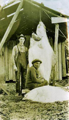
Chief Allen sits in chair on raised wooden platform, with bear skin over his knee, and two more bear skins laid on wood blocks in front of him. House stands behind picket fence in background. Pot and pan sit to right of chair in foreground.

Handwritten annotation on verso reads: "Albert Allen Kincolith (Nisga Chief)".

2009.7.1.140 · Item · [ca. 1925?]
Parte de Archdeacon W. H. Collison fonds

Group of six men sit and stand on small boat close to shore. Rev. W.E. Collison stands on far right (son of Marion and Archdeacon W.H. Collison).

Handwritten annotation on verso reads: "Dr. Macdonald Med officer (Kincolith) / Dr. [McQuarrie?] Med officer Victoria / Steven Clayton Native boat owner / Capt. Bary - Insp. of Indian Schools / W.E. Collison Indian agent. / Inspection trip to villages of upper Nass River".

Unidentified First Nations village
2009.7.1.163 · Item · [ca. 1910]
Parte de Archdeacon W. H. Collison fonds

Shoreline perspective of an unidentified coastal village situated on B.C.’s north coast. European style houses run parallel to a rocky shore. Seven men and one child stand within this frame and totem poles and a mortuary pole are also visible along the shoreline.

Children at play
2009.7.1.164 · Item · [ca. 1910]
Parte de Archdeacon W. H. Collison fonds

Seven young boys enjoying a game of tug-a-war alongside a wooden track. Track runs along a picket fence through a village. A small girl watches the fun from the sidelines and older woman carries a basket in the background. Handwritten annotation in pen on verso reads: “Native children at play”.

Highway 97
2012.13.1.3.022 · Item · Oct. 1975
Parte de J. Kent Sedgwick fonds

Image depicts Highway 97 at 15th Ave. looking north. Map coordinates 53°54'42.1"N 122°46'53.1"W

Index to Cariboo and Northwest Digest Magazine
2012.13.4.30 · Dossiê/Processo · 1986-2006
Parte de J. Kent Sedgwick fonds

File consists of notes, clippings, and reproductions relating to the Cariboo and Northwest Digest publication. Also includes a CD-R that contains Sedgwick's index spreadsheet and accompanying documentation about the publication.

Marching Band
2012.13.1.128.01 · Item · 1994
Parte de J. Kent Sedgwick fonds

Image depicts a marching band with numerous other unidentified individuals. One man is carrying a Canadian flag with the depiction of men in a boat and the words "Canada Sea-to-Sea" on it.

Marching Band - RCMP Chipmunk
2012.13.1.128.02 · Item · 1994
Parte de J. Kent Sedgwick fonds

Image depicts a marching band with numerous other unidentified individuals. One man is carrying a Canadian flag with the depiction of men in a boat and the words "Canada Sea-to-Sea" on it, and there is a mascot beside him that appears to be a chipmunk in an RCMP uniform.

Marching Band
2012.13.1.128.03 · Item · 1994
Parte de J. Kent Sedgwick fonds

Image depicts a marching band with numerous other unidentified individuals. One man is carrying a Canadian flag with the depiction of men in a boat and the words "Canada Sea-to-Sea" on it.

2023.5.1.23 · Item · [after 1975]
Parte de UNBC School of Planning and Sustainability fonds

Item is Map 1 of a group of five maps relating to a City of Prince George Study of Construction Aggregates by the firm Willis, Cunliffe, Tair & Company Limited. Map 1 shows development areas and population for 1984 and 1994. As the map is undated, it is unclear whether the 1984 and 1994 dates are future estimates.

2023.5.1.26 · Item · [after 1975]
Parte de UNBC School of Planning and Sustainability fonds

Item is Map 4 of a group of five maps relating to a City of Prince George Study of Construction Aggregates by the firm Willis, Cunliffe, Tair & Company Limited. Map 4 shows development areas, aggregate sources, and requirements for 1984 and 1994. As the map is undated, it is unclear whether the 1984 and 1994 dates are future estimates.