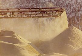
Photograph of dust collect bays, with unidentified man in background, at Nordenham Finishing Mill in Germany. Part of trip report.
Photograph of cyclone blockage detector at Nordenham Finishing Mill in Germany. Part of trip report.
Photograph of plastic inserts at Nordenham Finishing Mill in Germany. Part of trip report.
The map depicts where minerals can be found and also includes railways, highways, and roadways for easy access to desired minerals.
The map depicts the distribution locations and transportation routes for the processing of mineral and petroleum in British Columbia.
Publication contains booklet entitled "Canadian Crude Oil Supply-Demand Outlook and Related Issues" which was submitted to the West Coast Oil Ports Inquiry.
Photograph depicts an unidentified man engaged in the bagging process at Nordenham Finishing Mill in Germany. Part of trip report.
Photograph of automatic sewing machine. There is an unidentified man in the foreground to the right. Part of trip report to Nordenham Finishing Mill Germany.
Photograph of rotex screen at Nordenham Finishing Mill in Germany. Part of trip report.
Photograph of automatic bag weigh system at Nordenham Finishing Mill in Germany. Part of trip report.
Machinery visible in background.
Handwritten annotations on verso read: “Stewart, B.C.,” and “Bottom: at Granduc Copper mine with Mary Schindel, I drove the ‘Mitzie’”.
Machinery visible in background.
Handwritten annotation on verso reads: “John Lundquist, Mary Schindel”.
Publication contains an "Interim Submission of Kitimat Oil Coalition to West Coast Oil Ports Inquiry" published in Vancouver, BC.
Image depicts a logging area somewhere near Prince George, B.C.
Photograph of automatic recorder from front angle. Part of trip report to Nordenham Finishing Mill.
Photograph of deduster screen cleaner at Nordenham Finishing Mill in Germany. Part of trip report.
The map depicts mineral deposits in Northern British Columbia.
Publication contains an abridged version of the publication entitled "Termpol Assessment of the Navigational and Environmental Risks Associated with the Proposal of Kitimat Pipe Line Ltd. to Construct a Marine Oil Terminal at Kitimat, B.C." published by Transport Canada Coast Guard.
Image depicts the Britannia Mine, which closed in 1974 and is now a museum. "Anaconda" was the last operating owner.
Photograph of mill fan with supplied note "Ascolecric Limited, Brantford Ontario" and engineering notes for pressure for oil, water and gas.
Sign in foreground reads: “Stop Bull Shitting, [Phoney (crossed out)] Ioney”.
Handwritten annotation on verso reads: “The Kitimat Oil Port Environmental Lobby, didn’t believe I killed it. I did!”
Map depicts existing oil lines, oil lines proposed or under construction, product lines, existing gas lines, gas lines proposed or under construction, LPG lines, and LPG lines proposed in Canada and Northern USA.
Image depicts what appears to be the old, abandoned mill in Lamming Mills, B.C.
Photograph of equipment in tailings pile.
Map depicts the whole of Canada and notes: gas pipelines, gas gathering lines, proposed gas pipelines, oil pipelines, oil gathering lines, proposed oil pipelines, gas fields, oil fields, refining centres, extraction plants, and oil sands. There is a smaller subsequent map of Alberta highlighting these features in greater detail.
Map depicts existing harbour development in Stewart, with an enlargement of the west side of the harbour.
Satellite map of the district of Kitimat for the purpose of developing an industrial corridor.
Image depicts what appears to be a part of the old, abandoned mill in Lamming Mills, B.C.
"The Asbestos Sheet" is a newspaper that documents the community and work life of the residents of Cassiar BC. Content includes text and photographs, as well as jokes, comics, and games.
Semi-visible sign reads: “Supertanks - Pipelines S.O.S.”
Map depicts various gas projects across North America including: the "El Paso Project" along American and Mexican boarder; the "Arctic Gas Project" which runs from the Beaufort Sea through Alberta towards San Francisco and Chicago; the "Alcan Project" which runs through Alaska, British Columbia, Alberta and onwards to San Francisco and Chicago; the "Maple Leaf Project" which runs from the Beaufort Sea into Alberta; and the "Polar Gas Project" which runs from the Parry Islands and circles the Hudson Bay towards Quebec.
Image depicts what appears to be a small mill in the community of Crescent Spur, B.C.
This photograph is part of tramline study of bucket loads. It depicts the tramline station at the top of the mountain and terrain it runs above.
Photograph depicts crowd with individuals holding protest signs.
Publication contains report entitled "General Description of Ridley Island Coal Terminal Facilities, Prince Rupert, B.C." for Neptune Bulk Terminals Ltd.
Map depicts the regional district of Kitmat, but is extensively annotated showing the proposed route of the Kitmat Truck Ferry, running through Terrace and up into the "Yukon Markets," and the Kispiox Connector, running from Prince Rupert to Hazelton and further East along Highway 16 and north along the Kispiox River.
Map depicts the shipping highway routes across Canada. Primary, secondary, and access routes are noted as-well as proposed routes.
Detailed floor plan for fish-processing plant in Port Simpson. The drawing includes production plan showing locations of the workers.
Map depicts south eastern British Columbia, with highlighted annotations by Davies to emphasize location of rail lines.
Image depicts what appears to be a small mill in the community of Crescent Spur, B.C.
Photograph depicts tail rotor of helicopter in left foreground, as helicopter ascends or descends. It is possible that this photo may have been taken at Clinton Creek, Y.T. rather than Cassiar, B.C.
Photograph depicts row of houses behind trees. Power line, road, and vehicles in foreground; mountain in background.
Image depicts a Beehive Burner along the Nechako on River Road. Map coordinates 53°55'34.1"N 122°44'58.0"W
Image depicts a bee-hive burner beside a rail-road track at an unidentified mill somewhere in Prince George, B.C.
Image depicts the BCR tracks passing through a mill somewhere near the 100 Mile.
Image depicts an aerial view of the Gibraltar mine site's pits and waste dumps, north of Williams Lake, B.C.
Photograph depicts crusher plant in centre foreground. Shifter shack and vehicles can be seen in front of pit area. West Peak semi-visible in right midground. Mine valley an northwestern mountain range in background.
Photograph depicts plant buildings below, tailings pile in foreground. Valley and mountains in background. Handwritten annotation on recto of photograph: "CASSIAR".