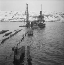
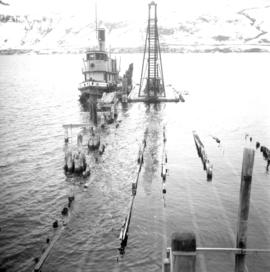
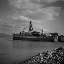
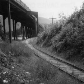
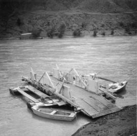
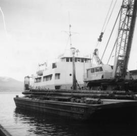
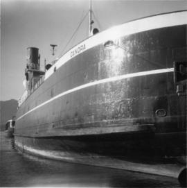
Photograph depicts "Canora," a CNR rail ferry that was recently retired from Fraser River-Victoria rail ferry work. Looking towards stern with the bow in the foreground.
Photograph depicts a CPR tug called the "Naramata." It was built in 1913 and sold out of service in 1970.
Photograph depicts a former sternwheeler building and repair slipway as well as a steam tug called the "Naramata." Steamer passengers ceased at the location in 1935 and rail service to the "Landing" in 1940.
Photograph depicts a replica of the "SS Beaver" built by the RCN in Esquimalt and moored in Vancouver, open to the public. Its pump handle that operated the capston, was reconstructed from a drawing done in 1870.
Photograph depicts a cannery at the seaward entrance to the south arm of the combined north arm of the Fraser river. Visible are a few rusted anchors. One was marked "Locomotive B.C. 100 Ibs. 1943 U.S. Navy."
Photograph depicts "H.R. Macmillan," a private yacht.
Photograph depicts the annual Bath-Tub Race that took place in Nanaimo. Visible is a competitor preparing for the start. There were 106 entries in that year.
Photograph depicts the "Canadian Princess" at permenant mooring as a restaurant, in Ucluelet.
Photograph depicts "Uchuck III" at its base in Gold River. It was operated by Nootka Sound Service, Ltd. It ran commercially to Zeballos and Tahsis. It also brought summer tourists to Friendly Cove, a historical site, as it held capacity for 100 passengers.
Photograph depicts a steam floating derrick (owned by Mckenzie Barge and Derrick Co. Ltd.) loading contariners from a scow into the hold of "Japan Line." Use of the crane on the non-deck side of a ship was unusual and the use a steam crane was quite exceptional, Davies notes.
Photograph depicts a Public Works Department vessel, "Essington II." It was fitted with a crane and used for snag removing, buoy work and light pile driving. Here, it was shown with the barge alongside it.
Photograph depicts "Fireboat" that was built for the Nanaimo-Vancouver Bath-Tub Race. The race had terminated at Fisherman's cove on the same day.
Photograph depicts one of the entries in the Nanaimo-Vancouver Bath Tub Race. Thre were 2112 entires and there was 32 mile crossing. Only 46 reached the finish line, of which this was one.
Photograph depicts the Hanceville Bridge that went over the Chilcotin River.
Photograph depicts the Lions Gate (suspension) Bridge.
Photograph depicts the Hazelton suspension bridge.
Photograph depicts the former bridge that crossed the Nanaimo River. Davies had taken a photograph of the bridge in June 1965, when it was in use. The bridge was superceded by a newer one a year prior the photograph was taken. On June 13, 1972, it was standing, but on this day the Highways Department took it down.
Photograph depicts a former highway bridge that was probably made obsolete when the new road to Edmonton was built in 1970.
Photograph depicts Cisco Bridge that spanned the Fraser River 36 miles below Lytton in Fraser Canyon. It was believed to be the origininal bridge that was built with under slung girders.
Photograph depicts Cisco Bridge that crossed the Fraser River 36 miles below Lytton in Fraser Canyon.
Photograph depicts a covered wooden grider bridge of the former Great Northern Railway spur that ran from north Washington state into B.C. at Keremeos, then west to Princeton. It was now only operating as far north as Keremeos.
Photograph depicts a CPR bridge over Pitt River.
Photo deoicts the lifting span of an existing rail bridge that was stuck in upwards position after the north pier had been struck by a freighter, putting the towers out of alignment. Visible is a crew working at the base of the north tower.
Photograph depicts three crossing at Second Narrows in Vancouver Harbour. On the left was a new CNR bridge being built. In the middle was exsiting CN track. To the right a high level road bridge is visible.
Photograph depicts a rail bridge crossing the Fraser River. Right-of-way suggested little usage, but tracks indicated a train had passed within the past 3 days since the photograph was captured.
Photograph depicts the Big Bar Creek ferry crossing over the Fraser River.
Photograph depicts houses being demolished on Beach Ave, West End, Vancouver.
Photograph depicts a well cared for house that was empty and being stripped along with 3 other house on Barclay to make way for a high rise apartment block. Built circa 1905.
Photograph depicts a house that at the moment was being pushed up on its side by a bulldozer.
Photograph depicts a house on 10th Ave., Vancouver.
Photograph depicts a large house that was actually the Sunset Beach Lodge. The western end of the block was being demolished. Image captured the last complete block of houses on Beach Ave.
Photograph taken looking northwest at a corner house and another home to its left. They were 2 of 9 houses in this Beach Block, the last block of houses on Beach Ave.
Photograph depicts a house that had just been repainted on the north side of Pender Street.
Photograph depicts one of the few remaining inhabioted and well kept houses that still survived in the very heart of downtown Vancouver.
Photograph depicts an Independent Order of Foresters 1895 house.
Photograph depicts one of the four houses on the corner of Barclay and Nicola. It was being demolished to make way for high rise apartments.
Photograph depicts the post office in Union Bay. It was a "Heritage" building and internally restored. Believed to have been built in 1908.
Photograph depicts a one roomed school that was seemingly still in use.
Photograph depicts HMCS Discovery Naval Reserve headquarters in located on Deadman's Island, Vancouver.
Photograph depicts the Department of National Defence Armoury headquarters of the British Columbia regiment.
Photograph depicts a courthouse in Richfield, 1 mile above Barkerville. It was the only building left standing of the former mining community.
Photograph depicts one of the churches on Denman Island.
Photograph depicts a church that was built of shaped logs on the territory of the Tsal'alh Nation on the road leading to Seton Lake. Church was derelict, but still held pews, plastic flowers and small shrines.
Photograph depicts "Butterchurch" that was built in 1870 under the direction of Father Rondeault of the Oblate Order for missionary work among the Comiakan Natives, a tribe of about 100. It was abandoned by about 1880 because of its location. It was recently restored as a historical shrine.
Photograph depicts a Ukranian Greek Orthodox church on the outskirts of Mission. A poster on its door stated that it been 50 years the church had been in Canada (1918-1968).
Photograph depicts a completely rebuilt saloon that was done so based on historical sketches and photos.
Photograph taken at Carmi, an old village between Rock Creek and Kelowna. Visible is an old hotel that was up for sale.
Photograph depicts "Salt Spring Island Trading Company Ltd." store.
Photograph depicts Golly's Grocery that was closed and slightly vandalised.