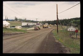
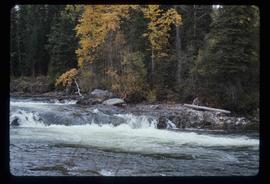
Image depicts an unknown individual with a raft on the Stellako River. The slide is labelled "fisheries research."
Image depicts a few buildings in Fraser Lake, B.C.
Image depicts an old house in Kispiox, B.C.
Image depicts numerous totem poles in Kispiox, B.C.
Image depicts a view of a lake that is near Telkwa, B.C. The slide is labelled as "Telkwa - McClure Lake," though it is possibly Tyhee Lake.
Image depicts the dock for ferries in Isle Pierre, B.C.
Image depicts the Battle Hill National Historic Site in Kitwanga, B.C.. The sign located there says: "The small knoll in the valley was a native fortress. Legends maintain that it was man-made: built to repel marauding coastal tribes. The hill was the scene of local tribal battles, and at one time was crowned with the defenders' buildings. Known as Dhawdezp, the unique mound is a prominent feature in the legends and history of the Indian people."
Image depicts a view of Francois Lake.
Image depicts a road and field somewhere near Grassy Plains, B.C.
Image depicts Grassy Plains, B.C.
Image depicts Danskin, B.C.
Image depicts a street in Burns Lake, B.C.
Image depicts the cemetery in Hazelton, B.C.
Image depicts a tombstone in the cemetery in Hazelton, B.C.
Image depicts Hazelton, B.C.
Image depicts the Telkwa river in Telkwa, B.C.
Image depicts the Skeena River.
Image depicts a turbine on the back of an industrial vehicle, located somewhere in Fort St. John, B.C. The slide is labelled "Site one dam; turbine prop. (Russian.)"
Image depicts an old, boarded up store in Isle Pierre, B.C.
Image depicts the Tsilcoh Falls, north of Fort St. James and somewhere near Pinchi Lake Road.
Image depicts a field along Telegraph Road, south-west of Vanderhoof, B.C.
Image depicts a view of the Fraser Lake.
Image depicts a boat on the Nechako Reservoir at Kenny Dam.
Image depicts a boat dock on the Nechako Reservoir at Kenny Dam.