Showing 658 results
Archival description![City of Prince George - Schedule C of the Official Community Plan - Long Range Land Use Map [October 2006 Amendment]](/uploads/r/northern-bc-archives-special-collections-1/6/d/6/6d643c10801eba2ac493689972e57429dba42ec7592f54cb55151b96362d7048/2023.5.1.40_-_2006_Oct_-_City_of_Prince_George_Long_Range_Land_Use_Map_JGP85_tb_142.jpg)
City of Prince George - Schedule C of the Official Community Plan - Long Range Land Use Map [October 2006 Amendment]

City of Prince George - Soil Removal and Deposit Bylaw No. 7022 - Schedule A

City of Prince George - Southwest - Schedule B of the Official Community Plan, Bylaw No. 5909
City of Prince George boundary expansion
City of Prince George boundary expansion
"City of Prince George Boundary Expansions Since Incorporation in 1915"
"City of Prince George Boundary Expansions Since Incorporation in 1915"
"City of Prince George Boundary Expansions Since Incorporation in 1915"
"City of Prince George Boundary Expansions Since Incorporation in 1915"
"City of Prince George Park and Trail Map"
"City of Prince George Park and Trail Map"
City of Prince George: Proposed electoral district boundary
City of Prince George: Proposed electoral district boundary

City of Prince George Study of Construction Aggregates - Development Areas & Aggregate Requirements

City of Prince George Study of Construction Aggregates - Development Areas & Population

City of Prince George Study of Construction Aggregates - Development Areas, Aggregate Sources & Requirements

City of Prince George Study of Construction Aggregates - Drill Hole Locations

City of Prince George Study of Construction Aggregates - Known Sources & Geology
City of Vancouver: Proposed electoral district boundary
City of Vancouver: Proposed electoral district boundary

City of Vancouver, British Columbia
"City of Vancouver, British Columbia"
"City of Vancouver, British Columbia"
City of Victoria: Proposed electoral district boundary
City of Victoria: Proposed electoral district boundary
Client Files of G.G. Runka Land Sense Ltd.
Client Files of G.G. Runka Land Sense Ltd.
Clinton Creek Aerial - Flight Index
Clinton Creek Aerial - Flight Index
Clones etc. 1999
Clones etc. 1999
"Cluculz Lake, British Columbia" 1977 map
"Cluculz Lake, British Columbia" 1977 map
Collected Works
Collected Works

College Heights-Southwest Existing Land Use
Colonial exploration maps
Colonial exploration maps
Columbia Cellulose Company, Ltd. fonds
Columbia Cellulose Company, Ltd. fonds
Columbia River Treaty
Columbia River Treaty
Community Involvement
Community Involvement
"Comox & Nanaimo Coalfields Properties and Geology"
"Comox & Nanaimo Coalfields Properties and Geology"
Company Operating History series
Company Operating History series
"Coquitlam, Port Coquitlam, Port Moody"
"Coquitlam, Port Coquitlam, Port Moody"
Corner Brook, Newfoundland Tourist Map
Corner Brook, Newfoundland Tourist Map
Cottonwood Island and Island Cache
Cottonwood Island and Island Cache
Cottonwood Island general file from the City of Prince George
Cottonwood Island general file from the City of Prince George
Cottonwood Island maps and plans
Cottonwood Island maps and plans
"Cottonwood River"
"Cottonwood River"
"Cowichan Lake, British Columbia"
"Cowichan Lake, British Columbia"
"Cowichan Lake, British Columbia"
"Cowichan Lake, British Columbia"

C.P. 825, 826, 410, 420 - F.L. A18165 - Aleza Lake Forest - P.G.T.S.A.
"Cranbrook Hill Greenway Multi-use Trail"
"Cranbrook Hill Greenway Multi-use Trail"
Crooked Creek Provincial Forest
Crooked Creek Provincial Forest
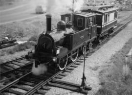
David Davies Railway Collection
Development Plan Forest Licence A27771
Development Plan Forest Licence A27771
Development Study - Northern Resources
Development Study - Northern Resources

Dewey Logging Co. Ltd. Logging Plan of T.S.X. 72108

Dewey Logging Co. Ltd. X72108

Dewey Logging Co. Ltd. X72108 annotated
Distribution of Solid Mineral and Petroleum Resources in British Columbia
Distribution of Solid Mineral and Petroleum Resources in British Columbia
"Distribution of Uranium Exploration Mineral Claims and Radioactive Occurrences"
"Distribution of Uranium Exploration Mineral Claims and Radioactive Occurrences"
District of Kitimat Land Ownership
District of Kitimat Land Ownership
Dr. Paul Sanborn fonds
Dr. Paul Sanborn fonds