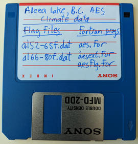
Floppy contains flag files (AL52-65F.dat, AL66-80F.dat) and Fortran programs (AES.for, AESEXT.for, AESFLG.for).
File contains a 1931 original copy of "The Aleza Lake Forest Experiment Station: A Brief Statement of its Purpose and Development". Includes photographs.
Item is "The North Ridge Eco-Trail Guide: Aleza Lake Research Forest".
Diagram reflects outline for the proposed Ranger Station at the Aleza Lake Experimental Forest.
Map reflects forest type boundary line, bogs and swampy non-forested areas, creeks, lakes, rivers, tree species labels of spruce, balsam, and birch, stand descriptions, historical timber sale boundaries, stand history symbol, gravelled secondary roads, unimproved old roads, management compartment boundary, research forest boundary, ecological reserve boundary, and old growth emphasis areas.
Map commissioned from Ministry of Forests Prince George Region from Madrone Consultants shows Aleza Lake Research Forest Access and Access Management. Map is 3 of 6. Map shows the following road types: all weather 1-lane gravel road, dry weather road, and proposed road access. Also shows areas for parking/turnaround, toilets, and information signs.
Map commissioned from Ministry of Forests Prince George Region from Madrone Consultants shows Aleza Lake Research Forest ecosystems. Map is 5 of 6. Map shows many sub-types of the following ecosystem types: upland, lowland wet forest, wetlands, and the Bowron floodplain benches. Ecosystem classification and mapping by Oikos Ecological Services Ltd.
Map commissioned from Ministry of Forests Prince George Region from Madrone Consultants shows Aleza Lake Research Forest site series classification. Shows ecosystem types that encompass the SBSwk1 Subzone of the Aleza Lake Research Forest.
File contains photocopies of survey notes from 1954.
Photograph depicts several log booms on the water with a forested area in the foreground.
Photograph depicts piles of wood planks and log booms in the foreground with a waterfall in the background.
Photograph depicts a man standing on the deck of a sailboat with a view of a cannery along the shoreline of Ocean Falls with mountains in the background.
Photograph depicts a distance perspective of several cannery buildings with a body of water in the foreground and a mountain range in the background.
Photograph depicts three men at a whaling station with debris on the ground and a large elevated tank in the background.
Photograph depicts several fishing boats on the water with a wooden dock in the foreground to the left of the image.
Photograph depicts a cannery in front of a forested mountains with water in the foreground.
Photograph depicts a steamshovel at work.
Photograph depicts unidentified man standing near mining ditches.
Photograph depicts an unidentified man standing at the top of an empty wooden flume (?) situated at the top of a mountainside in front of a forested landscape.
Photograph depicts a distance perspective of an unidentified man standing in a large ditchline that runs through a forested landscape.
Photograph depicts a gravel road carved into the forested landscape.
Photograph depicts a large water-filled ditchline in front of a forested landscape.
Photograph depicts wooden roadways criss-crossing a forested landscape.
Photograph depicts a loaded dogsled being pulled by four sled dogs against a winter forest backdrop.
Photograph depicts six sled dogs and three men standing beside a loaded two horse wagon on a forest road.
Photograph depicts two men (O'Brine on left) standing in front of a log building. Handwritten note on verso reads: "Consulting engineer for Crocker 1st National Bank, San Franscisco. Examining (?) Fleuving & Downey Leases with object of taking in dredge."
Photograph depicts a wooden roadway traversing a forested mountainside.
Photograph depicts a large ditchline with a steamshovel and forested landscape in the background
Photograph depicts a large water filled ditchline with a steamshovel and forested landscape in the background.
Unidentified mining excavation equipment (might be a type of drill) located in front of a forested landscape.
Photograph depicts a bulldozer pulling sleds loaded with large pipes and steel drums potentially heading for the mines for assembly.
Photograph depicts a bull dozer driving down a gravel road through a forested landscape.
Photograph depicts a bulldozer pulling sleds loaded with large pipes and steel drums potentially heading for the mines for assembly. Close up of 2004.8.1.57
Photograph depicts three men standing on a rocky terrain along a creekbed in front of a forested landscape. Annotation on verso of photograph reads: "Taken to show carpest(?) stones seen on Creek. Shows old Five (?) workings of "Upper Toboggan" Claim situated on lower end of Cos' upper Creek leases. Dr. Mathews writing from Germansen Camp - 12/9/71. to Editor colonist mentions "Upper Toboggan Claim is actually paying $30 to $50 per day per wau(?)" - Old timers were able to work this low lying beach owing to shallow and rich gravels -- were stacked by hand. Snow water aided sluicing."
Photograph depicts a wooden pile trestle that leads through a wooded landscape. Annotation on recto of photograph reads: "Pile tressle upper end. Sec.#1. Bents 12" centers - 3 only 12" piled driven to refusal; caps 10" x 12" "
Photograph depicts a man leaning over in front of a tall wooden pile driver in a forest environment. Annotation on recto of photograph reads: "Pile driver sec.#1. This is a gravel point"
Photograph depicts a access road leading through a forested area.
Photograph depicts a ditch cut into a forested landscape. Handwritten annotation on recto of photograph reads: "New Germansen ditch length 10 miles; width of ditch bottom 15 feet"
Photograph depicts a creek running through a forested landscape. Handwritten annotation on verso of photograph states: "View up Germansen Creek"
Photograph depicts two unidentified men standing beside a log pile on the edge of a river that flows alongside a forested landscape. Annotation on verso of photograph reads: "Logs skidded ready to float down to mill, Germansen Placer Ltd."
Photograph depicts a ditch constructed by a bulldozer within a forested area. Annotation on recto of photograph reads: "Bulldozer on Sec. #4 - partly finished ditch"
Photograph depicts four men posed within or beside two horse drawn carriages in a winter forest landscape. Annotation on recto of photograph reads: "Skookum Davis (?) Bert McCorkell, Bert McDonald - Coming out Nov. 10th, 1934"
Photograph depicts a bulldozer convoy pulling empty flats through a forested landscape.
Photograph depicts a ditch cut through a forested landscape.
Photograph depicts a gas (?) shovel digging out a ditchline through a forested landscape.
Photograph depicts the front end of a steam shovel in a cleared gravel area in front of a forested landscape.
Photo depicts a large sled loaded with large metal tubing, a tent and a pile driver(?)
Photograph depicts a steam shovel operating in a ditch cut through a forested landscape. Handrwitten annotation on recto of photograph: "steam shovel sec. #3 July 15th"
Photograph depicts a caterpillar tractor and a bulldozer working on a ditch cut through a forested landscape. Handwritten annotation on recto reads: "see #1 cut go wide on top". Handwritten annotation on verso reads: "caterpiller tractor and bulldozer working on ditch"