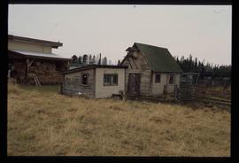
Affichage de 2097 résultats

Archival description
Eaglet Lake Creek
2012.13.1.89.095 · Pièce · [1980?]
Fait partie de J. Kent Sedgwick fonds

Image depicts the creek flowing into Eaglet Lake. A grey area of hill on the right side of the image appears to be the Giscome Quarry. Map coordinates 54°04'26.2"N 122°22'04.3"W

Train on Hansard Bridge
2012.13.1.89.137 · Pièce · 1999
Fait partie de J. Kent Sedgwick fonds

Image depicts a train on the Hansard Bridge across the Fraser River looking west. Map coordinates 54°04'37.7"N 121°50'39.9"W

Cookhouse
2012.13.1.89.175 · Pièce · 2001
Fait partie de J. Kent Sedgwick fonds

Image depicts a cookhouse at an uncertain location.

Two Small Sheds
2012.13.1.89.177 · Pièce · 2001
Fait partie de J. Kent Sedgwick fonds

Image depicts two small sheds at an uncertain location. The slide labels them as "Giscome bldgs in Blackburn."

Dawson Creek
2012.13.1.91.01 · Pièce · Sep. 1974
Fait partie de J. Kent Sedgwick fonds

Image depicts a road with a guardrail and open fields somewhere near Dawson Creek, B.C.

W.A.C. Bennett Dam
2012.13.1.91.02 · Pièce · Sep. 1974
Fait partie de J. Kent Sedgwick fonds

Image depicts a section of the Peace River blocked off by the W.A.C. Bennett Dam. The dam itself is not visible in the image.

A Highway
2012.13.1.91.07 · Pièce · Oct. 1978
Fait partie de J. Kent Sedgwick fonds

Image depicts a stretch of highway, possibly Highway 29 or 97.

Peace River
2012.13.1.91.23 · Pièce · Oct. 1978
Fait partie de J. Kent Sedgwick fonds

Image depicts the Peace River, possibly near Hudson's Hope, B.C.

Sediment Layers
2012.13.1.91.24 · Pièce · Oct. 1978
Fait partie de J. Kent Sedgwick fonds

Image depicts an unidentified individual standing in front of a rock face with visible sediment layers. Located somewhere in the Peace River Region, possibly near Hudson's Hope.

Sediment Layers
2012.13.1.91.27 · Pièce · Oct. 1978
Fait partie de J. Kent Sedgwick fonds

Image depicts a wall of rock with visible sediment layers at an uncertain location in the Peace River Region, possibly near Hudson's Hope.

Railway Tracks and Rocks
2012.13.1.91.39 · Pièce · 1979
Fait partie de J. Kent Sedgwick fonds

Image depicts a group of individuals who appear to be searching through the rocks near a railway track. It is possibly part of an educational trip.

Chetwynd - Motor Hotel and Esso
2012.13.1.91.40 · Pièce · 1979
Fait partie de J. Kent Sedgwick fonds

Image depicts several businesses in a small section of Chetwynd, B.C. There is a motor hotel and a half-visible sign for an Esso gas station.

W.A.C. Bennett Dam?
2012.13.1.91.44 · Pièce · 1979
Fait partie de J. Kent Sedgwick fonds

Image depicts several unidentified individuals lying on a hill outside what is most likely the W.A.C. Bennett Dam in Hudson's Hope, B.C.

People on a Bridge
2012.13.1.91.49 · Pièce · 1979
Fait partie de J. Kent Sedgwick fonds

Image depicts several unidentified individuals standing on a bridge; it possibly crosses the peace River.

Sediment Layers
2012.13.1.91.60 · Pièce · 1979
Fait partie de J. Kent Sedgwick fonds

Image depicts a large group of people examining the sediment layers in a rock face.

Peace River
2012.13.1.93.27 · Pièce · 1978
Fait partie de J. Kent Sedgwick fonds

Image depicts the Peace River and visible layers of sediment deposits in the surrounding cliffs.

Peace River
2012.13.1.93.36 · Pièce · 1978
Fait partie de J. Kent Sedgwick fonds

Image depicts the Peace River, possibly somewhere near Fort St. John, B.C.

View of Pine Pass
2012.13.1.93.55 · Pièce · 1978
Fait partie de J. Kent Sedgwick fonds

Image depicts a view of Pine Pass on the border between Alberta and British Columbia in the Rocky Mountains.

Fraser, B.C.
2012.13.1.98.02 · Pièce · 1999
Fait partie de J. Kent Sedgwick fonds

Image depicts the small town of Fraser, B.C. Located on the Klondike Highway.

The Tutshi
2012.13.1.98.06 · Pièce · 1999
Fait partie de J. Kent Sedgwick fonds

Image depicts half of a ship, which is named the Tutshi, in Carcross, Y.T.

The Caribou Hotel
2012.13.1.98.07 · Pièce · 1999
Fait partie de J. Kent Sedgwick fonds

Image depicts the Caribou Hotel and the Matthew Watson General Store in Carcross, Y.T.

Atlin - Nurses' Residence
2012.13.1.98.21 · Pièce · 1999
Fait partie de J. Kent Sedgwick fonds

Image depicts a building which once served as the residence for two nurses in Atlin, B.C. A sign in front of the house reads: "Grateful Atlinites built this house in 1902 for their first missionary nurses, Helen Bone and Elizabeth Mitchell, who came here in 1899 and lived in a crude shack while valiantly and humanely caring for sick and dying pioneers."

Photographer and Skeletal Remains
2012.13.1.52.26 · Pièce · 1980
Fait partie de J. Kent Sedgwick fonds

Image depicts an unknown woman taking pictures. Nearby are the skeletal remains of an unknown animal. The location is somewhere near the upper Fraser Canyon.

Woman with Camera
2012.13.1.52.27 · Pièce · 1980
Fait partie de J. Kent Sedgwick fonds

Image depicts an unknown woman with a camera. Nearby are the skeletal remains of an unknown animal. The location is the upper Fraser Canyon.

Upper Fraser Canyon
2012.13.1.52.30 · Pièce · 1980
Fait partie de J. Kent Sedgwick fonds

Image depicts a view of the upper Fraser Canyon. The Fraser River is visible on the left side of the image.

Upper Fraser Canyon
2012.13.1.52.31 · Pièce · 1980
Fait partie de J. Kent Sedgwick fonds

Image depicts a view of the upper Fraser Canyon. The Fraser River is visible on the left side of the image.

Road and Scenery
2012.13.1.52.45 · Pièce · [1980?]
Fait partie de J. Kent Sedgwick fonds

Image depicts a road somewhere in the Upper Fraser Canyon, and a view of the hills and trees.