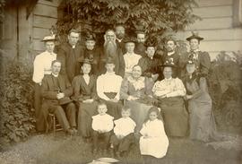
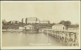
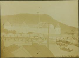
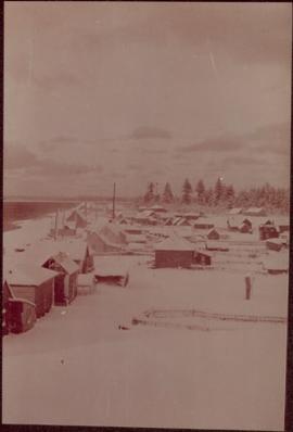
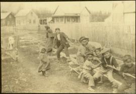
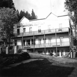
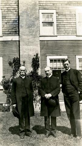
Group stands in front of a large building, W.H. Collison on left.
Handwritten annotation on verso reads: "Arch. WH Collison / Bishop [Du Vernet?] / Arch. Bish. [Du Pencior?] at Prince Rupert".
Group stands in front of a large building, W.H. Collison on left.
Handwritten annotation on verso reads: "Arch. WH Collison / Bishop [Du Vernet?] / Arch. Bish. [Du Pencior?] at Prince Rupert".
Group of men, women, and children pose in front of large building.
Handwritten annotation on verso reads: "Metlakatla BC / with Bishop Ridley - 4th from left - back row / Mrs Ridley - 4th from left - front row / [?] - [super?] of Ridley Home (beside the Bishop) / Father Hogan - behind the Bishop".
Large church stands behind white fence, unidentified man visible on front steps. Photograph depicts the first church built in Metlakatla, which was burned in a fire in 1901, and replaced in 1903.
Handwritten annotation on verso reads: "With love, from your two old friends JH [& AM Keen?]".
Banner at front of sanctuary reads "Do this in remembrance of Me".
Handwritten annotation on verso reads: "Interior of old church. Built by natives themselves".
Groups of men and women can be seen gathered on paths between two large totem poles.
Handwritten annotation on verso reads: "Totem Park Pr Rupert park."
Photograph depicts a totem pole standing on what appears to be a large wooden deck or boardwalk, view of the city in background.
Handwritten annotation on verso reads: "Totem pole in park in Prince Rupert".
Photograph depicts a large ship behind dock buildings. Railroad crosses foreground, hills visible on shore in background.
Handwritten annotation on verso reads: "Ship in Pr. Rupert dry dock during Great War 1915?".
Photograph depicts a large ship behind dock buildings. Railroad crosses foreground, hills visible on shore in background.
Handwritten annotation on verso reads: "Pr. Rupert Drydock".
Photograph depicts large buildings on shore. Three unidentified individuals can be seen walking on dock in foreground.
Printed on image: "METLAKATLA B.C. / McRAE BROS"; handwritten annotation on verso reads: "A section of Metlakahtla, showing Church & Schoolhouse." See also item 2009.7.1.58 for similar image also featuring the new church building at Metlakatla, B.C.
Photograph depicts fenced area in front of church building with turret. Other community buildings can be seen in background.
Handwritten annotation on verso reads: "Metlakatla Church. Replacement for larger church lost in village fire 1903?" See also item 2009.7.1.55 for similar image depicting new church building at Metlakatla, B.C.
Photograph depicts an unidentified man walking on path in front of Bishop Ridley's home. Several children can be seen in fenced yard in midground.
Handwritten annotation below image reads: "Ridley Home and Mission house Metlakahtla."; on verso: "Chapter XXVII / Heading for Chapter / Ridley Home Metlakahtla".
Photograph depicts a man and woman standing on steps to a round tower in fenced area. Roofs of other buildings can be seen below on right; water and shore visible in background.
Printed on image: "Indian Jail, Metlatkla".
Photograph has been altered with drawings of people on shore fighting canoes approaching the town. Buildings stand behind fenced and walled areas in background.
Handwritten annotation below image reads: "Drawing by F.A., old Hudson B. [...?]"; on verso: "27. To head Chapter III. No. 2. Tsimshians and Haidas fighting on shore at Fort Simpson."
Tall monument featuring a man's profile stands in foreground. Base of monument features writing on plaques.
Handwritten annotation on verso reads: "No. 30 Paul [Segaics?] Monument at Port Simpson".
Handwritten annotation on verso of photograph reads: "Tombs. ? Massett".
Caption under printed version of photo in W.H. Collison's book 'In the Wake of the War Canoe': "At Masset, Queen Charlotte Islands, B.C. The side-posts are solid and sunk in the ground. The horizontal piece is hollow, and contains the corpse. These tombs are now falling through decay." (see page 216).
Large bear carving sits on top of wide pole, erected in memory of a chief of the Bear crest. Lines of houses stand in background.
Printed below image: "Totem Pole. Old Massett. Q.C.I / J.D. Allen photo Co."; handwritten below: "Mortuary Pole Bear [Crest?]"; on verso: "For Chapt. XIX. The old style and the new. Mortuary Pole & modern houses. No. 3. W.H.C. Oct. [6/ ?] 13".
Photograph depicts village buildings along shore.
Handwritten annotation on verso reads: "Massett in Winter dress."
Photographs depict large building in fenced area, trees in yard and in background.
Handwritten annotations on verso read: "Mission House at Massett QCIs"; "Mission House at Massett - Mother & Dad lived there."
Photograph depicts an unidentified individual leaning against a large overturned dugout canoe; barrel, bucket, and wood planks in foreground. Houses and other buildings can be seen on shore above beach, and two unidentified individuals stand in distance on far right.
Handwritten annotations on verso read: “Haida canoe on beach at Masset / ? 1898”; “No. 4 Page 5. Haida Canoe ready for steaming to [widen?] out and finish.”
An original negative of this photograph is held by the Canadian Museum of Civilization, no. 26664.
Photograph depicts a tomb elevated over grassy area.
Handwritten annotation on image reads: "26. Front of Indian tomb."; on verso: "Upper Nass River."
Chief Allen sits in chair on raised wooden platform, with bear skin over his knee, and two more bear skins laid on wood blocks in front of him. House stands behind picket fence in background. Pot and pan sit to right of chair in foreground.
Handwritten annotation on verso reads: "Albert Allen Kincolith (Nisga Chief)".
Photograph depicts large church building behind white fence. Other buildings visible in background.
Handwritten annotation on verso reads: "New Church Kincolith Nass River BC".
Photograph depicts an empty canoe floating beside a canoe full of fish. Hills visible on opposite shore in distance.
Handwritten annotation on verso reads: "Loaded with fish - Nass River".
Two carved poles stand in front of a wide wooden building. Forest in background.
Printed below image: "OLD KAGAAN TOTEMS, KETCHIKAN, ALASKA".
Shoreline perspective of an unidentified coastal village situated on B.C.’s north coast. European style houses run parallel to a rocky shore. Seven men and one child stand within this frame and totem poles and a mortuary pole are also visible along the shoreline.
Seven young boys enjoying a game of tug-a-war alongside a wooden track. Track runs along a picket fence through a village. A small girl watches the fun from the sidelines and older woman carries a basket in the background. Handwritten annotation in pen on verso reads: “Native children at play”.
Totem pole stands alone against a mountainous background.
Photograph depicts a derelict building in Ladysmith on Vancouver Island built approximately between 1900 and 1905.
Photograph depicts St. Anne's log church on French Creek, near Parksville on Vancouver Island. The church was built in 1894 and was still in use at the time.
Photograph depicts a bandstand at English Bay in Vancouver, B.C.
Photograph depicts peat barns on the New Westminster Highway on Lulu Island, near the #8 Rd., half a mile west of rail crossing.
Photograph depicts a house and barns on River Rd. in Surrey, 1 mile east of Deas Island Tunnel.
Photograph depicts the building for the Vancouver Supply Company located at 25 Alexander St. in Vancouver, B.C. It is at the center of the old downtown and may have been a former fire hall.
Photograph depicts the former C.P.R. route connecting existing False Creek rail yards and the Burrard shoreline main line. The view is looking southwest from the intersection of Powell St. (in foreground) and Columbia St. (not seen) in Vancouver.
Photograph depicts an unused church at Clayburn, near Abbotsford, B.C. The church and about half the buildings in the village are made of brick.
Photograph depicts the schoolhouse of Chinatown in Nanaimo, B.C. It is the only surviving building; the others were destroyed by a fire.
Photograph depicts the Grand Central Hotel at the intersection of Marpole Ave and Hudson St. in south Vancouver. The hotel was built in 1912 by J.J. Graver and run from 1913-1915. It re-opened in 1920 as a home for incurables (veterans). In 1937 it became the provincial infirmary and closed in May 1965.
Photograph depicts a corner building on Chilco and West Georgia St. facing Stanley Park in Vancouver, B.C. The view is looking east across Chilco St.
Photograph depicts the site of a former C.P.R. connection between the mainline into Vancouver and False Creek yards at West Pender St. In Vancouver. The rails are not used but still appear in the street and on the parking lot on the far side. Another parallel set of tracks 30 yards to the east are in daily use.
Photograph depicts the Silver Ledge Hotel, Ainsworth Hot Springs, on the west side of Kootenay Lake, north of Nelson.
Photograph depicts a barn at Darfield, near Barriere, about 35 miles north of Kamloops. The English timbered cottage developed from this architectural form.
Photograph depicts East Pender St., looking west towards the Vancouver Sun newspaper office near Abbot St. in Vancouver, B.C.
Photograph depicts the Upper Clearwater Hall on a dirt road between Clearwater (70 miles north of Kamloops) and the entrance to Wells Gray Provincial Park. The cracks between the logs recently re-cemented.
Photograph depicts a barn at Port Guichon, 1 mile west of Ladner, Delta.
Photograph depicts the Delta Municipal Hall on Main St. in Ladner, B.C.
Photograph depicts a disused schoolhouse with the dates "1925" and "1902" on it. It is on River Rd. on the south bank of the Fraser River in Delta, opposite the west end of Annacis Island.
Photograph depicts Alberni St. in the west end of Vancouver. It is directly opposite the Vehicle Testing Station, in the 1700 block. The view in the photo is looking east.
Photograph depicts a courthouse in Vancouver, B.C. surrounded by a fence with paintings.
Photograph depicts a painting on a fence outside a courthouse on Howe St. in Vancouver, B.C. The painting shows the natural grandeur of B.C. partially blocked out by a super motel with a bewildered moose forced to become an ornamental fountain. The whole forecourt is being bulldozed to make way for the Centennial fountain.
Photograph depicts a wharf at Sechelt village on the Sechelt Peninsula. The view is looking southeast towards Vancouver.