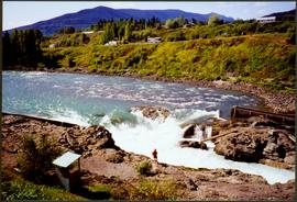
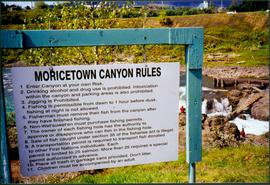
Mostrar 1279 resultados

Archival description
Sign Featuring Moricetown Canyon Rules
2008.3.1.22.36 · Item · [ca. 1995]
Parte de Bridget Moran fonds

Photograph depicts sign in foreground outlining rules and restrictions for behaviour at Moricetown Canyon. Traditional fishing territory visible behind sign at waterfall in the Bulkley River, B.C. Highway and buildings can be seen in background.

Large crowd in Prince Rupert harbor
2009.7.1.249 · Item · ca. 1880-1920
Parte de Archdeacon W. H. Collison fonds

Large crowd is gathered around main building in a harbor. Many boats visible in foreground. Smoke from tugboat partially obscures the scene. Annotation on recto reads: "Prince Rupert BC. Photo by MCrae Bros."

SS Arna arrived in Prince Rupert BC
2009.7.1.267 · Item · 30 March 1914
Parte de Archdeacon W. H. Collison fonds

Photograph of ocean liner SS Arna docked in a harbour. Foreground shows two individuals on a dock in the lower right corner and a large pile of lumber in the lower left corner. Annotation on recto reads: "S.S. Arna arrived in Prince Rupert B.C March 30th 1914"

Prince Rupert wharf and waterfront
2009.7.1.273 · Item · [ca. 1880-1920]
Parte de Archdeacon W. H. Collison fonds

Photograph of a small vessel on the ocean with a dock and harbour buildings in the foreground. Tents and piles of lumber can be seen among the buildings. Annotation on recto reads: "The Wharf, Prince Rupert, BC. 1657." Printed annotation on verso reads "The Wharf, Prince Rupert, BC J. Howard A. Chapman, Victoria. BC. 1657."

Oolichan drying at Fishing Bay, Nass River, BC
2009.7.1.130 · Item · [ca. 1878 - ca. 1920]
Parte de Archdeacon W. H. Collison fonds

Photograph depicts two men standing beside beds of fish laid out to dry. More oolichan fish hang on tall structures in background.

Handwritten annotation on verso reads: "'Food for winter' Oolichans drying at Fishing Bay, Nass River".

Early steam donkey at Promised Land Park
2013.6.36.1.004.17 · Item · [1964?]
Parte de David Davies Railway Collection

Photograph depicts an early type of steam donkey mounted on a flatcar and attached to a Shay Tank. It is displayed on the roadside at Promised Land Park, probably near Forks, on the Olympic Peninsula in Washington state.

Steam crane in yard of Lions Gate Lumber Co.
2013.6.36.1.004.37 · Item · [July 1965]
Parte de David Davies Railway Collection

Photograph depicts a steam crane in the yard of the Lions Gate Lumber Co. at the foot of Lloyd St. in North Vancouver. The crane was made by the Brown Hoisting Machinery Co. in Cleveland, Ohio and is undated. It has a 20 ton capacity, is well maintained, and freshly painted.

Steam crane at lumber yard in Sechelt, B.C.
2013.6.36.1.004.39 · Item · Apr. 1966
Parte de David Davies Railway Collection

Photograph depicts a steam crane in a lumber yard on the north side of Porpoise Bay in Sechelt on the Sechelt Peninsula. The steam crane has been converted to diesel and was made by the Brown Hoisting Co. from Cleveland, Ohio. It lifts 21 tons at a 12ft radius and 5 tons at 35ft radius, and is in daily use. The 200 yards of rail track form a "Y" with the bottom piece onto the wharf.

Small coal drift mine
2013.6.36.1.005.02 · Item · Aug. 1964
Parte de David Davies Railway Collection

Photograph depicts a small coal drift mine which worked perhaps 6 months prior to the picture being taken. Timber lands # 8, Cranberry, about 17 miles south of Nanaimo.

Mine near Moyie, BC
2013.6.36.1.005.10 · Item · Oct. 1965
Parte de David Davies Railway Collection

Photograph depicts a mine 200 yards south of Moyie village, which is 20 miles south of Cranbrook. It produced silver, zinc, and lead from 1900-1910 and had a smelter a quarter mile away. The shaft was 900 ft. deep, with levels going under Moyie Lake. The head gear dates from 1925-1935 and has electric winding.

Upper Fraser Mill
2012.13.1.87.046 · Item · [between 1975 and 1995]
Parte de J. Kent Sedgwick fonds

Image depicts Upper Fraser mill yard with log deck and beehive burner in silhouette across railroad tracks. Located in Upper Fraser, B.C. Map coordinates 54°07'01.5"N 121°56'29.6"W

Upper Fraser Mill
2012.13.1.87.064 · Item · [between 1975 and 1995]
Parte de J. Kent Sedgwick fonds

Image depicts numerous log decks at the Upper Fraser sawmill. Map coordinates 54°07'10.8"N 121°56'51.7"W

Giscome Sawmill
2012.13.1.87.168 · Item · [between 1975 and 1995]
Parte de J. Kent Sedgwick fonds

Image depicts the mill site at Giscome, B.C. Map coordinates 54°04'19.7"N 122°22'04.7"W

Giscome Sawmill
2012.13.1.87.170 · Item · [between 1975 and 1995]
Parte de J. Kent Sedgwick fonds

Image depicts the mill site at Giscome, B.C. Map coordinates 54°04'19.7"N 122°22'04.7"W

P.G. Logging
2012.13.1.122.01 · Item · June 1975
Parte de J. Kent Sedgwick fonds

Image depicts an aerial view of areas that have been used for logging around Prince George, B.C.

Clear Cut Logging
2012.13.1.122.03 · Item · Oct. 1975
Parte de J. Kent Sedgwick fonds

Image depicts a highway, and a section of mountain in the background which is bare due to clear-cut logging. It is possibly somewhere near Prince George, B.C.

Clear Cut Logging
2012.13.1.122.04 · Item · Oct. 1975
Parte de J. Kent Sedgwick fonds

Image depicts a logging area, and a section of mountain in the background which is bare due to clear-cut logging. The slide is also labelled "logging show." It is possibly somewhere near Prince George, B.C.