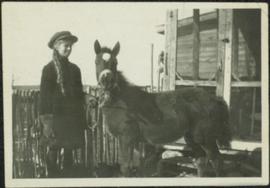
Photograph depicts a young woman believed to A.K. Bourchier's niece Jean. Young colt stands on right, picket fence and porch to wood building in background. Handwritten annotation on recto of photograph: "To my dearest Uncle Alan. This is little Betty Beauty's little colt. I broke her in to lead myself so I feel quite proud."
View of snow capped mountains in the distance, trees and river in mid ground. A Jeep type vehicle is on a bridge in the mid ground with river and sandbar in the foreground. Handwritten annotation on verso in pen reads: “Cassiar Road. Cottonwood River crossing”
Photograph depicts what was believed to be the engine house of a private spur belong to the former Jingle Pot Coal Mine. The turning wye was retained by the Esquimalt & Nanaimo Railway and was lcoated behind the photograph at another 150 yards of track.
Photograph depicts what was believed to be a commencement of the private line to the Jingle Pot Coal Mine that had long since been closed. At the point where the cars disappear, line diverges into a wye which meets the Esquimalt & Nanaimo Railway tracks at the Wellington depot.
Photograph depicts a two road engine house, located about 300 yards west of the Wellington flag stop on the Esquimalt & Nanaimo Railway. Visible is a house that was believed to be a part of a private railway operated by the Jingle Pot Colliery.
Photograph depicts the interior of an engine house which may have been the property of Jingle Pot Colliery. It was located 300 yards west of the Wellington flag stop of the Esquimalt & Nanaimo Railway.
Photograph depicts existing CPR trackage as well as private trackage believed to be owned by Jingle Pot Colliery.
Image depicts a road, possibly Joffre Creek Road. The slide is simply labelled "Joffre cr."
Collection consists of 73 photographs featuring the construction of the John Hart Highway in Prince George, BC from 1945-1946. Images depict construction, machinery, workers, bunkhouses, persons, wildlife, and buildings all associated with this construction project around the Summit Lake region of the city.
John Hart HighwayClose up of man against corner of unidentified building. Handwritten caption above this photo reads: "Workman Truck Driver". Handwritten annotation on recto of photo reads: "John [Jmeson?] Edmonton".
Handwritten annotation on verso reads: “Return to Tom,” and “Iona with John Lapadat (L) and Carmen Graf (R), Smithers / Sept. 77.”
Photograph depicts part of the Vernon yards just south of the principal round crossing. A box car without wheels on a sunken warehouse spur is visible.
Photograph depicts a daily freight car and a few CPR locomotive switching cars.
Photograph depicts the joint CPR and CN depot at Vernon. The depot office had three employees working inside. Vernon is at mile 46.2 from Sicamous, on the Okanagan Subdivision of the CPR. It has daily way freight.
Photograph depicts the joint CPR and CN depot at Vernon. It shows a general view of the trackage, opposite the former depot, which is now attractively used for other purposes. The caboose on the left is CP # 437369, built in July 1949, and fairly recently painted.
Photograph depicts the joint Car and Cn depot at Vernon. The photo shows CPR caboose #437369, which was built in July 1949. It is used on a regular basis for local freights.
Footage of men grooming horses, saddling horses and loading horses as they prepare for a journey. Location is believed to be Holt Homestead.
Boat floats close to shore in foreground, forest and hills on opposite shore in background. Joyce is the daughter of Bertha and W.E. Collison, and the granddaughter of Marion and Archdeacon W.H. Collison.
Handwritten annotation on verso reads: "Upper Nass River Sept. 1933. Joyce with Tom Moorhouse & the medical officer".
Postcard depicts the junction of Fraser River and Thompson River, near Lytton, BC
Photograph taken at the station in Jura. Depicts a waiting shack that used to be around the bend on the left side of mile 60.1. Until the 1970s, there were three tracks at the location. Track on the left side was the running line. Middle trackage was passing siding, while track on the right (lifted at the time the photograph was taken) was a spur/siding that held 33 cars. The helper locomotives were from Princeton, but were being disengaged in Jura.
Photograph taken at the station in Jura. Looking towards the beginning of a passing loop in Jura.
Photograph taken at the Kalamalka flag stop and siding that took up to 40 cars. A section house used to exist there, Davies notes. Virtually there was no public access in former days, so the siding was most likely used as a storage place for Kelowna fruit. A private speeder is found in the shadows on the main line.
Photograph taken on the shores of Kalamalka Lake.
Photograph depicts siding at the Kalamalka flag stop.
Photograph depicts Kamloops Auxiliary car #3. CN #54960 visible on the repair track after its roof renovation was completed.
Plan depicts the location of buildings occupied by the Northern Construction Company on the old Kamloops Station ground.
Postcard depicts Kamloops station at about 1895.
Image depicts the townsite of Keithley Creek, B.C.
Image depicts a blue truck and a camper in the wooded area surrounding the townsite of Keithley Creek, B.C.
Photograph taken at the Kekuli Bay Provincial Park and boat launch. Image captures the view of all 25 speeders on an Okanagan tour of "Motor Car Operators West" (a U.S. group with western Canadian additions). On this segment, Davies travelled in the fifth speeder from the front.
Photograph taken at the Kekuli Bay Provincial Park and boat launch. On the speeder meet, there was always a semi-official photograph of the whole group and this was the selected spot. Here, no power boats could take the see-saw.
Photograph taken on the Kelowna "main" line, which was perhaps half of a mile south of the Lumby Junction on the very outskirts of Vernon.
Map depicts the city of Kelowna and area. Annotated by Davies to emphasize rail lines.
Map depicts area around Kelowna, with annotated Kettle Valley Railway Carmi subdivision line, Hydraulic Lake, and McCulloch.
Image depicts a boat on the Nechako Reservoir at Kenny Dam.
Image depicts a boat dock on the Nechako Reservoir at Kenny Dam.
Photograph depicts ore haul truck at dump in mine, driver visible, mountain range in background. Handwritten annotation on recto of photograph: "Kenworth - Model 802 dumping stripping waste at 6565 Elevation", on verso: "1961".
Photograph taken at Kettle River Bridge. Immediately on the far side of the river, the track did a sharp turn to the side of Christina Lake.
Photograph taken at the Kettle River Bridge on the former Boundary Subdivision about 12 miles due east of Grand Forks. Visible is a deck truss and dock plate girder spans that were believed to have originally a covered bridge.
Image depicts a woman walking along the trail of the Kettle Valley Rail Road.
Image depicts the trail of the old Kettle Valley Rail Road.
Image depicts a man standing on the old Kettle Valley Rail Road.
Image depicts the old Kettle Valley Rail Road.
Image depicts several unknown individuals standing on the old Kettle Valley Rail Road.
Image depicts the Okanagan Kettle Valley, with the Kettle Rail Road faintly visible among the trees
Image depicts the trail of the old Kettle Valley Rail Road.
Image depicts a woman standing on the old Kettle Valley Rail Road.
Image depicts a view of Kettle Valley, with a bridge of the old Kettle Valley Rail Road visible on a slope.
File consists of documentary photographs taken by David Davies of Kettle Valley Railway equipment found in Brookmere, British Columbia.
File consists of documentary photographs taken by David Davies of the Kettle Valley Railway line from Merritt to Midway, British Columbia.