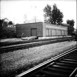
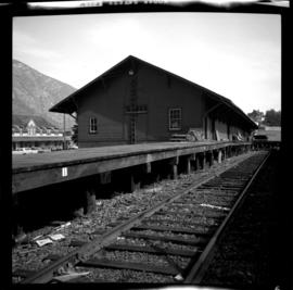
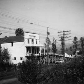
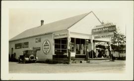
Photograph depicts a general store owned by Acton Kilby that was still operated by him at age 81. His family had moved from New Westminster in 1902 to run the store. The CPR depot originally connected direcly to the second floor of the building. Harrison Mills lay at the junction of the Harrison and Fraser Rivers and was an important site during steamboat days. Now it was a backwater of 3 dwellings beside the railway.
Photograph depicts young girl standing on front deck of "WANAMAKER'S GENERAL MERCHANDISE." Car visible on left, gas pump in front. Trees and neighbouring house visible in background. Handwritten annotation on recto of photograph: "ATLIN."
File includes six aggregations of photographs which have been assembled in this file in order to maintain the integrity of each group by keeping the photos arranged together, though each group features operations pertaining to multiple files in this subseries. Includes groups featuring photos from 1961, 1965 1971, a helicopter trip, a community album, and a workplace album. Photographs depict images pertaining to the following operations at Cassiar, B.C.: mining, milling, maintenance, labratory tests, and tramline and town operations. Images featuring operations of the company town include the grocery store, bank, churches, school, library, lounge, pool, theater, community center, outdoor recreation, hospital, dentist, cafeteria, bus route, residences, air strip, firehall, laundromat, park, police, and newspaper.
Handwritten photo album caption below this photo reads: " 'General Duties' (G.D.) man at Officers' Quarters." Photograph depicts man in sweater vest and tie sitting in front of closed door with "R.C.A.F OFFICERS QUARTERS" printed on side. There is a broom on right, boots on left, and wood slat sidewalk in foreground.
Royal Canadian Air ForceSubseries consists of photographic material pertaining to the following subject areas: mine operations; plant operations;labour strike 1970s images; townsite operations of the company towns of Cassiar and Clinton Creek (including community activities associated therein and townsite development); as well as, images of mines not owned by Cassiar Asbestos Corporation, but which are believed to have been used for operational research purposes.
Image depicts a gauging tower at Shelley, B.C.
Image depicts a gathering of people for an uncertain event at an uncertain location, possibly in Lillooet, B.C. A few tents are set up in the picture.
Image depicts a gas compression station located at Summit Lake, north of Prince George, B.C.
The item is a black and white photograph depicting a garage and covered storage area on a farm.
Image depicts the sign to Gang Ranch, located in the Upper Fraser Canyon, with graffiti on it.
Image depicts the Gang Ranch office.
Image depicts the Gang Ranch house.
Image depicts a wooden structure at Gang Ranch. It is possibility an elevated water trough.
Image depicts the Upper Fraser Canyon from what appears to be the entrance to Gang Ranch.
Image depicts Gang Ranch, with a sign warning that the area is patrolled by Range and Logging Patrols, in the Upper Fraser Canyon.
Image depicts the Gang Ranch House in the Upper Fraser Canyon.
Image depicts the house of the owner of Gang Ranch.
Image depicts the general store and post office on Gang Ranch.
Image depicts Gang Ranch in the Upper Fraser Canyon.
Handwritten annotation on recto of photograph: "FURNACE PAD AUG 25/64." Photograph depicts construction worker standing on elevated wood platform. Three other men can be seen working in construction area. This location is believed to be under the conveyor to crusher building, retaining wall in midground.
Photograph depicts two log buildings in fenced area on lake shore, forest trees in background. A man can be seen standing near docking area and small boat pier extending into water in foreground. Handwritten annotation on recto of photograph: "Fur Farm Red Rock Lake". This location is believed to at mile 27, north of Summit Lake.
Photograph depicts a group of men, women, and children walking across beach towards water. Buildings visible on shore in left background.
Handwritten annotation on verso reads: "Funeral party - en route to boat Metlakatla BC (Taking body over to Grave Island".
Elevated street view of Fulton Street in Prince Rupert, BC. City Hall is in the left foreground. Hills and water are visible in the background. Printed annotation on recto reads: "Fulton St. Prince Rupert. B.C. W.W.W."
Image depicts a number of people standing at what appears to be a farm fishery [?] on the Fulton River.
Image depicts the entrance of the Fulton River.
The photograph depicts three metal fuel tanks at the exterior of the CN roundhouse in Prince George, BC. Reproduction of photograph from 1984.
Street view photograph taken at the intersection of Front Street and Carson Avenue. Several men are gathered at Cowan's Hardware store on the corner. Also visible in this photograph is the Cariboo Hotel (visible furthest to the left), and the British American Hotel which is partially visible behind the J.A. Fraser store. Printed annotation on recto reads: "On Front Street, Quesnel, B.C."
Handwritten annotation on recto of photograph: "Front St. Hazelton in Winter. 12 J.W. [...]" Tree line, field, and hills in background. Handwritten annotation on verso of photograph: "Miss. Nellie [Nelville] G. Caranaugh".
Photograph depicts a tomb elevated over grassy area.
Handwritten annotation on image reads: "26. Front of Indian tomb."; on verso: "Upper Nass River."
Image depicts a view of Prince George from Carney Hill.
The item is a photograph depicting the Friendship Centre building at 1600 3 Avenue Prince George. The building's colour is blue and white.
Photograph depicts a freight shed located on the north side of the rail line and some 200 yards west of the Mission City CPR depot.
Photograph depicts a freight shed at the Nelson CPR depot. There is a terminal spur on the south side of the shed and road trucks on the north side. The road side of the main depot building can be seen in the left rear of the photo. The view is facing east.
The item is a photograph of the Freemason Building at 480 Vancouver Street, Prince George. The photograph is taken from the corner of Vancouver Street and 4th Avenue.
This item is a photograph of the Freemason building at 480 Vancouver Street, Prince George.
Handwritten caption beside this photo reads: "Fred Youngstrom & Kitchen Staff. 1946." Photograph depicts Fred standing to right of three woman, a young girl, and a dog. The group is standing on the snow-covered front steps of a (kitchen?) building, lumber pile on far right. A large metal triangle is hanging behind Fred. It is believed that this photograph was taken at the camp at Summit Lake B.C. (see item 2005.3.57).
Handwritten caption above this photo reads: "Fred Youngstrom in [church shirt?]" Photograph depicts two men (Fred on left) standing on snow-covered road in front of car with a British Columbia license plate "93-650". A wood pile and long building with porch can be seen in background in front of forest trees. It is believed that this photo was taken at the camp in Summit Lake, B.C. (see item 2005.3.57).
Photograph depicts two men standing to left of Fred Murray on balcony of large building or structure speculated to be in the Cassiar valley. Portion of log structure in left foreground, man and hauling trucks on road in background.
The Fred Jeffery Collection consists of three photograph albums comprising a total of 303 b&w photographs all dating from ca.1924-1933. The subject matter of these images consist primarily of the fishing industry, river & landscapes, salmon cannery images (housing, people, workers, machinery, boats) on the Nass River and North Pacific Coast. Notable are the photographs depicting indigenous (Nisga'a) people and places and Chinese and Japanese cannery workers. Identified canneries featured in these photographs include: Mill Bay Cannery, Namu Cannery, Klemtu Cannery, Shushartie Bay Cannery, Balmoral Cannery, North Pacific Cannery, Nass Harbour Cannery, Port Essington Cannery, Kitwanga Cannery, Port Nelson Cannery, Alert Bay Cannery, Dominion Cannery and ABC Co. Cannery. Photographs also include images of the Canadian Pacific Railway in both Vancouver and Sicamous, BC., as well as, images of the Legislative Assembly buildings in Victoria, the 1924 Special Service Squadron ships in Vancouver, early construction of the University of British Columbia in Vancouver, and town overviews of Yokohama, Japan (pre WWII).
Jeffery, FredImage depicts the small town of Fraser, B.C. Located on the Klondike Highway.
Image depicts a rail road bridge over the Fraser River, possibly somewhere in the Lillooet area.
Image depicts a view of the Fraser River in Lillooet, B.C.
Image depicts a bridge over the Fraser River in the Upper Fraser Canyon; possibly near Gang Ranch.
Image depicts a cabin at Fraser Lake, B.C. which is labelled on the slide as an example of a "square log" dovetail joint.
Image depicts the old Hudson Bay Trading Post with several unknown individuals present in Fraser Lake, B.C.
Image depicts the old Hudson Bay Trading Post in Fraser Lake, B.C.