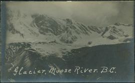
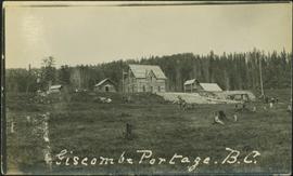
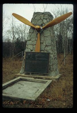
Image depicts the grave of Frank Russell "Russ" Baker in Fort St. James, B.C.
Photograph depicts a grassy plateau leading to forested foothills and rising to rocky mountain slopes.
Photograph depicts a grassy plateau with a tree in the foreground leading to forested foothills and rising to rocky mountain slopes.
Photograph depicts a grassy, snow-covered plateau leading to forested foothills and rising to rocky mountain slopes.
Photograph depicts a grassy plateau leading to forested foothills and rising to rocky mountain slopes.
Photograph depicts a grassy plateau leading to forested foothills and rising rocky mountain slopes.
Photograph depicts a landscape shot of a grassy area with fruit-bearing trees in the background.
File consists of versions and components of Ainley's Social Science and Humanities Research Council (SSHRC) grant, "Re-explorations: science and environment in 19th and 20th century Canada and Australia"; conference proceedings from a presentation of "Tracking Life Course Changes. Canadian Women in Science"; and Ainley's book chapter, "Gendered Careers: Women Science Educators at Anglo-Canadian Universities, 1920-1980."
Photograph depicts Granite Falls near the Wigwam Inn, Indian Arm, Vancouver, B.C.
Photograph depicts Granite Falls and wharf at Indian Arm, looking west from the top of the falls.
Image depicts a large, electric shovel at a mine site somewhere in Granisle, B.C.
Image depicts a drill for blasting holes at a mine site somewhere in Granisle, B.C.
Image depicts numerous bags of blasting powder at a mine site somewhere in Granisle, B.C.
Image depicts an 80 tonne truck at a mine site somewhere in Granisle, B.C.
Handwritten annotation on verso of photograph: "G.T.P. 1st Passenger Train From Prince Rupert. Mile 45. June. 14th 1911. Copyright. F. Button. PHOTO. Pr. Rupert. No. 240." Photograph depicts three men (two sitting on chairs) on caboose of train. Power poles run parallel to tracks, which curve to the right of the image. Train tracks in foreground, forest and mountain in background.
Image depicts the Fraser River and the Grand Trunk Pacific Bridge from Cottonwood Island Park.
River in foreground, trees and cliffs in background.
River in foreground, trees on shore in background. Handwritten annotation on verso of photograph: "Grand Canyon Fraser R."
River in foreground, trees and rocky shore in background.
Photograph depicts an unidentified person seated on rocks in foreground. River crosses midground, cliffs and trees on opposite shore in background. Unidentified structures believed to be buildings can be seen on opposite shore. Handwritten annotation on verso of photograph: "Grand Canyon. fraser R."
File contains slides depicting images of the Fraser Canyon from somewhere around 1975.
File consists of notes, clippings, and reproductions relating to the Grand Canyon of the Fraser River. The Grand Canyon of the Fraser is a short gorge on the upper Fraser River, about 6 kilometres south-southwest of Hutton. The canyon head was about 171 kilometres by river from Fort George, and is about 100 kilometres due east of downtown Prince George.
Image depicts a grain elevator in Prince Rupert, B.C.
Image depicts a clearing through the woods, possibly an abandoned grade for the BCR. It is possibly located on Iron Road South, near Woodpecker B.C.
File consists of the "Government of Canada Outline of Evidence for the British Columbia Utilities Commission Inquiry into the Kemano Completion Project: Phase 4".
File consists of the "Government of Canada Outline of Evidence for the British Columbia Utilities Commission Inquiry into the Kemano Completion Project: Phase 3".
File consists of Alderdice's copy of "Government of Canada Outline of Evidence for the British Columbia Utilities Commission Inquiry into the Kemano Completion Project: Phase 3". Also includes a document entitled "Questions for Mr. Lemon Relating to the Canadian Government Outline of Evidence", likely written by Alderdice.
File consists of outgoing correspondence from BCUC to the government of Canada as well as incoming correspondence to BCUC from the government of Canada. Prominent correspondents include Harry Wruck and law firm Farris, Vaughan, Wills & Murphy.
Footage of golden eye duck and ducklings on a lake.
Speculated locations include Anahim Lake, Ulkatcho Lake or Fenton Lake.
Image depicts the Fraser River in the Grand Canyon, B.C.
Image depicts a set of rail road tracks and an old, collapsing log building somewhere in Goat River, B.C.
Image depicts an old, collapsing log building somewhere in Goat River, B.C.
Image depicts the CN Railway and Station at Goat River, B.C.
Image depicts a cabin and several sheds somewhere in Goat River, B.C.
Photograph depicts glacier and snow in mountains. Handwritten annotation on verso of photograph reads: "Glacier, Moose River. B.C."
Image depicts the Gitwinksihlkw Elementary School in Gitwinksihlkw, B.C.
Side perspective of wooden swings covered in snow. Handwritten annotation in pen on verso reads: “The school swings.”
Image depicts the Giscome, B.C. mill site looking west. Map coordinates 54°04'18.5"N 122°21'57.7"W
Image depicts what is possibly the quarry located at Eaglet Lake in Giscome, B.C.
Photograph depicts people and tree stumps in grass areas. Buildings stand on higher level in midground, forest in background. Handwritten annotation on verso of photograph: "Giscombe Portage. B.C.", on recto: "Seaback & Huble"
Image depicts the Giscome mill foreman's house on the hill, with Eaglet Lake in the background and numerous piles of logs in the foreground. Map coordinates 54°04'28.0"N 122°22'05.8"W
Image depicts the Giscome mill foreman's house on the hill. Map coordinates 54°04'28.0"N 122°22'05.8"W
Image depicts an open area with Eaglet Lake in the background. It depicts the previous site of the mill at Giscome, B.C. Map coordinates 54°04'19.7"N 122°22'04.7"W
Image depicts several houses and the Giscome saw mill in Giscome, B.C. in the background. Map coordinates 54°04'20.9"N 122°21'53.1"W
Image depicts Giscome with the school on the left, the remnants of the town site in the middle and the church on the right. Map coordinates 54°03'58.2"N 122°22'04.8"W
Image depicts a farm in Giscome, B.C.
Image depicts a large, old and collapsing barn, as well as a nearby house of the dairy farm in Giscome, B.C. Map coordinates 54°03'53.3"N 122°21'22.6"W
Image depicts the dairy farm in Giscome, B.C. Map coordinates 54°03'53.3"N 122°21'22.6"W