2023.2.2.12.7
·
File
·
2007-2008
Part of Dr. Paul Sanborn fonds
179 results with digital objects
Show results with digital objects
2023.2.2.13.2
·
File
·
Jul. 2007
Part of Dr. Paul Sanborn fonds
These images were obtained on the helicopter flights to and from the Klutlan Glacier study site. The outbound sequence (#5590-5706) starts from the base camp at the White River crossing on the Alaska Highway and heads south, to a point just upvalley of the debris-covered terminus (approx. 10-15 km from Alaska border), and turning back north to the landing spot on the Generc River floodplain close to the study site (see Fig. 1 in paper). On the return leg at the end of the day, the flight initially went upvalley to pick up another party (#5884-5926), before turning north and returning to base camp (#5929-5993).
2006.18.6.10
·
File
·
[2008?]
Part of Aleza Lake Research Forest Society fonds
Aerial photograph depicts a view overlooking the Georges farm. Note on back stated that this photograph was presented in a frame to the Georges in 2008.
2023.2.2.13.4
·
File
·
2008
Part of Dr. Paul Sanborn fonds
2016.5.1.64
·
File
·
[2008]
Part of Harry Coates fonds
File consists of pages from a binder beginning with "A Tour of Experimental Plot Location: Prince George Forest District" accompanied by documentation on various EPs and handwritten notes.
2016.5.2.12
·
File
·
[2008-2019]
Part of Harry Coates fonds
File consists of five posters Harry Coates created to convey his ideas about sustainable forest management. Posters contain photographs and text.
2012.13.2.11.02
·
File
·
2009-2010
Part of J. Kent Sedgwick fonds
File consists of notes, reproductions, and clippings relating to the W. Lamb and Sons Lumber Sawmill in Island Cache and its development. File predominantly includes printed photographs and photographs from the Exploration Place Museum database depicting the sawmill. Includes "Engines" printed email from Trelle Morrow to Kent Sedgwick (24 Nov. 2009).
2011.9.01.08
·
File
·
2009
Part of Forest History Association of BC fonds
File consists of Harry Gairns' speaking notes for his 18 Sept. 2009 banquet talk at the "Exploring Our Roots: Forest History in Our Communities Annual Conference of the Forest History Association of BC" at UNBC in Prince George, September 19, 2009. Gairns' speech was entitled "Prince George Forest History - The 50s and the 60s".

2023.2.2.7.3
·
File
·
2009-2023, predominant 2009-2010
Part of Dr. Paul Sanborn fonds
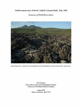
In July 2009, Dr. Paul Sanborn undertook the first soils field research at the Fort Selkirk volcanic field in central Yukon, with helicopter support and funding from the Yukon Geological Survey. This file includes the following data sets gathered from the research:
- Ft Selkirk 110114069.xls [particle size analysis data, CANTEST]
- S1090final.xlsx [chemical analysis data, Ministry of Forests & Range, Analytical Chemistry Laboratory]
- S1112final.xlsx [chemical analysis data, Ministry of Forests & Range, Analytical Chemistry Laboratory]
- Ft Selkirk 2009 soils data (updated Sept 15, 2010 and April 10, 2023).xls [consolidated lab data for all 2009 samples]
2023.2.2.8.20
·
File
·
2009
Part of Dr. Paul Sanborn fonds
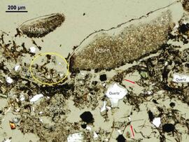
2023.2.2.7.4
·
File
·
2009
Part of Dr. Paul Sanborn fonds
In July 2009, Dr. Paul Sanborn undertook the first soils field research at the Fort Selkirk volcanic field in central Yukon, with helicopter support and funding from the Yukon Geological Survey. This file includes digital photographs of the 2009 field work at the Ft. Selkirk site. Some of the digital photographs have been annotated as PDFs.
- Ft Selkirk 110114069.xls [particle size analysis data, CANTEST]
- S1090final.xlsx [chemical analysis data, Ministry of Forests & Range, Analytical Chemistry Laboratory]
- S1112final.xlsx [chemical analysis data, Ministry of Forests & Range, Analytical Chemistry Laboratory]
- Ft Selkirk 2009 soils data (updated Sept 15, 2010 and April 10, 2023).xls [consolidated lab data for all 2009 samples]
2023.2.2.7.2
·
File
·
2009, 2023
Part of Dr. Paul Sanborn fonds
In July 2009, Dr. Paul Sanborn undertook the first soils field research at the Fort Selkirk volcanic field in central Yukon, with helicopter support and funding from the Yukon Geological Survey. This document is a complete transcription of field notes, with
soil and site photographs.
2016.5.1.57
·
File
·
2010-2011
Part of Harry Coates fonds
File consists of "Ministry of Forests Tour Frost Lake Experimental Plots Prince George Forest District: Post Treatment Review" June 28, 2010 and documentation on various Eps including E.P. 858.04.01, 895.03, 786.06, 973.02.
2006.18.4.05
·
File
·
2010
Part of Aleza Lake Research Forest Society fonds
File consists of two copies of the Forest History Association of British Columbia Newsletter, Issue No. 88, published July 2010. This issue contains a synopsis of the 2009 Forest History Conference that look place at UNBC Prince George.
2016.5.2.15
·
File
·
[after 2010]
Part of Harry Coates fonds
File consists of notes, charts, and photographs showing forest management. May have been for a presentation by Harry Coates.

2023.2.2.6.4
·
File
·
2010
Part of Dr. Paul Sanborn fonds
This data set consists of elemental analysis data for selected B horizons from Wounded Moose paleosols sampled by Tarnocai and Smith. The file includes the original ALS lab report, additional panes showing comparison of replicates, and calculation of a weathering index.
2016.5.1.94
·
File
·
[2011]
Part of Harry Coates fonds
File consists of printed tables of data from SX 84118.
2016.5.1.91
·
File
·
[2012]
Part of Harry Coates fonds
File consists of Harry Coates CV.
2016.5.1.44
·
File
·
June, 2012
Part of Harry Coates fonds
File consists of materials for a presentation given by the BC Ministry of Forests, Lands and Natural Resource Operations in June 2012. File consists of an information package entitled "Timber Tenures in British Columbia: Managing Public Forests in the Public Interest" and a printed slide presentation entitled "Overview of BC Forest Tenures".
2006.18.1.36
·
File
·
2013
Part of Aleza Lake Research Forest Society fonds
File consists an oral history with Harry Coates recorded by Barbara Coupe. Includes a transcript and audio recording.
2006.18.1.37
·
File
·
2013-2014
Part of Aleza Lake Research Forest Society fonds
File consists an oral history with Michael Jull recorded by Barbara Coupe. Includes are transcripts and audio recordings.
2006.18.1.38
·
File
·
2013
Part of Aleza Lake Research Forest Society fonds
File consists an oral history with John Revel recorded by Barbara Coupe. Includes are transcripts and audio recordings.
2016.5.2.13
·
File
·
2016-2017
Part of Harry Coates fonds
File consists of fliers for Northern Silviculture Committee Winter Workshops in 2016 and 2017.
2016.5.2.14
·
File
·
2019
Part of Harry Coates fonds
File consists of possible speaking notes and related materials by Harry Coates on the need for sustainable forests.
2000.1.1.1.13
·
File
·
[between 1951 and 1992]
Part of Cassiar Asbestos Corporation Ltd. fonds
Photographic negatives depict men on tour in unknown locations in Russia. Images depict urban areas, mining areas, construction of buildings, railway, mineral samples, and equipment including dump truck and electric shovel. Also includes images of area speculated to be a mine pit. Men on tour are dressed in formal attire.
Handwritten annotation in pencil on envelope containing negatives: "Russian 'Asbest' Mine Slides" "7 copies of each - 23 negatives - 161 prints".
2012.05.01.03
·
File
Part of Columbia Cellulose Company, Ltd. fonds
File consists of a document entitled "A Summary: History and Progress," which contains an overview of Columbia Cellulose Company's operations, ownership and financing, management staff, progress during 1968, three-year profit plan targets 1969-1971, and general information (magazine reprints, photographs, 1967 annual report, and 1968 interim reports).
2000.1.1.1.11
·
File
·
1971- 1977
Part of Cassiar Asbestos Corporation Ltd. fonds
Six metal storage cases containing primarily slides depicting drill core sections in wooden storage trays. Cases contain inventories of slide images as well as annotations which document the year, drill hole number, and the length along the drill hole from which core sections are taken. In addition to the documentation of drill core sections, the cases contain slides depicting the following subjects: “Representative samples” of drill core fragments, drill core fragments in perspective, “physical characteristics” of the drill cores and the storage trays, the pit mine, a worker in a plaid shirt, close up shots of the geology of the working face, and images annotated “SHOTS OF JADE BOULDER CORE J5-J1”. Five slides originally filed separately and stamp dated “Jul. ‘73” depict what is speculated to be employees working on the diamond drilling project include 2 images annotated ‘R. Dickin Aug ‘72’, ‘I. Oliver Aug ‘73’, ‘S. Zimmer Aug ‘73’, and ‘core shack ’73’. The cases contain 234 7x7cm slides and at least 8 5x5 cm slides which are duplicates of the remaining images. The file also contains a slide strip containing several 7x7 cm slide images.
2000.1.1.3.06
·
File
·
1979 - 1989
Part of Cassiar Asbestos Corporation Ltd. fonds
File contains images depicting various landslides near Cassiar BC. Set of 20 photographs (with 9 corresponding negative strips) date stamped June 1987 depict landslide near creek and dirt road with a Cassiar company truck. Set of 5 black and white photographs found in envelope marked "D. Stewart" are likely from 1988-1989 and depict a rockslide on the south western side of the pit mine, near the tramline. Album entitled “6200 DUMP SLIDE / SPRING, 1979” contains 34 photographs depicting aerial shots of a massive rockslide on the eastern slope of McDame Mountain, originating from the mine waste dump. Several images from album show greenish water pooling in the toe of the slide.
2000.1.1.3.08
·
File
·
July 1987 - Apr.1989
Part of Cassiar Asbestos Corporation Ltd. fonds
File contains images of mine operations and construction, as well as a variety of other subjects.
- Elements of the underground mine are depicted, including miners working, the marked rock face, yellow ducting and ventilation fan, the portal, mesh rockbolted onto adit walls, shotcrete being applied, and stacked mining construction materials.
- Mining equipment depicted in this file includes underground ore haulage truck, Wabco ore haulage truck, jackleg drill, stoper drill, scoop tram, jumbo drill, conveyor, pickup trucks, unidentified mixing or grinding machine, a cable wagon and half constructed ore haulage truck in the shop, and a continuous miner (also known as alpine miner or roadheader).
- A set of images show a dozer and a lowbed truck transporting a temporary building down the pit mine access road.
- Several images depict drill core fragments, asbestos ore, and geological features of the mine.
- Mining related process are depicted, including a young man sluicing and panning, a mine building under construction, and an unidentified steel frame structure with a hydraulic device suspended on a rail.
- A set of images shows a railway or highway construction project, including stockpile of construction materials, rail cars, caboose, locomotive, front end loader, dump truck, concrete mixing trucks, semi-trucks, and a rail car with large steel drums which are speculated to be specialized for tunnel construction.
- Further images show what is speculated to be tunnel construction.
- A set of images at a high ceiling underground mine which is not Cassiar depicts a man in a suite by a underground ore haulage truck, and other mining vehicles including a crane.
- A set of images depict an ungulate herd, possibly bighorn sheep, on a mountain side.
- The file includes several images which depict personal life, presumably from a family vacation, and access to these images may be restricted. These images depict man with children on a fishing trip, adults and children around a pool, a woman on a motorcycle, and a house and kitchen. Several groups of images are contained in envelopes annotated with dates and “K. Minty”.
2000.1.1.3.15
·
File
·
1953 - 1970
Part of Cassiar Asbestos Corporation Ltd. fonds
File contains photographs depicting machinery, individuals, buildings, and mining processes at the open mine on McDame Mountain, Cassiar, B.C. Some photos depict benches from open strip mining, and two images feature models of the mine (1955 and 1970). Machinery depicted includes shovels, bulldozers, tractors, ore haul trucks (Kenworth, International Harvester, and Wabco), air track drills, blasthole drills, and Ingersoll-Rand Drill. Identified individuals include Fred Murray, R.R. [Kiresan?], C.E. Bronson, Bill Giachino, and "Sam".
2000.1.1.3.16
·
File
·
1973-1991
Part of Cassiar Asbestos Corporation Ltd. fonds
File contains photographs featuring:
- the pit mine: fault line, geology, snowdrifts, plowed snow, blast patterns marked by orange cones, mist, and surrounding mountains.
- Pit mine is depicted by aerial photographs and a profile diagram.
- Several photographs also depict what is speculated to be the portal to the underground mine adit in the early phases of development.
- One photograph depicts the shop building in the pit mine, used for maintenance of mining equipment and to house the primary crusher.
- Several photographs show office interiors and personnel and it is speculated that these photographs were taken in the upper floor of the shop building.
- Several photographs depict small sinkholes in the pit mine.
- Mining equipment depicted includes pickup trucks, front end loaders (including a Cat 988), ore haulage trucks, scoop trams, D8 Caterpillar dozer, grader, mining drill rig, jumbo drill, rock hammer, P&H excavator, and wireline extensometer. Photolab envelopes accompanying these materials were annotated “R. Tyne” and “falling ground”. Slide sleeves were annotated “Mine Nov-Dec 1975”, “AERIAL SHOTS OF MINE 1976” and “Phase 8 Dec 1975”.
- Photographs of a Gardner Denver blasting drill at the mine and other ground drills working
- Photograph of proposed power line to #1 switchback in 1975,
- Collection of photographs of a Wsbco truck with corresponding mechanical transfers of those photographs.
- Also photographs a Gardner Denver drill and a Bucyrus Erie drill that was rented to Cassiar Mine in 1974. This collection includes a depiction of an accident with these drills.
- An additional collection of photographs of #709 Drill that was involved in minor accident. A pipe was either damaged or was the cause of the accident.
- Negative collection of photographs with corresponding notes of descriptions.
- Photographs of G.D. 80 Drill - Blasthole drill at work in the open pit.
- Photographs part of Month End Reports from January - June 1980
- Photographs of portable toilets used on Mine site.
- Photograph collection of mine garage January 21, 1988
- Photograph collection of what is believed to be the inside of the mine garage and various storage units and equipment. Marked "Receiver File" in original enclosure.
- Photos of Crane in 1984.
- An Album of 192 photographs of machinery in March of 1976 working at the mine site. Some of the equipment from either the plantsite or the mill is also depicted.
2000.1.1.4.4
·
File
·
1963 - 1978
Part of Cassiar Asbestos Corporation Ltd. fonds
File contains photographs taken for promotional purposes.
- Two photos depict a Cassiar display at an unknown event in 1963.
- Eight photos were professionally taken for use in the 1978 Cassiar Asbestos Corportaion Ltd. Annual Report, and possibly other publications. These photos depict a skyscraper and products made with asbestos.
- Additionally, two hand painted postcards of McDame Mountain and Christmas Tree House are included that may have been used for promotional reasons. Also, four slides of a display, "Story of Asbestos."
- five photographs of unofficial tour of Cassiar via airplane in the 1970s.
2009.5.3
·
File
·
[ca. 1895 - 1950]
Part of Taylor-Baxter Family Photograph Collection
This photograph album consists of photographs of remote police barracks at Mile 47 and Mile 29; early settlements and/or mercantile stores at Tete Jaune Cache, McBride, Sand Creek, Fort George and South Fort George; Grand Trunk Pacific Railway forestry and railway camps; scows and paddlewheel conveyors on the Fraser River; automobiles; community leisure activities; as well as, images of the Bourchier family. The following South Fort George establishments are identifiable within these photographs: Empress Hotel, Ah Yee General Merchant, German Bakery, Northern Hotel, South Fort George Drug Store & Post Office, St. Michael’s Church, Prince George Hotel, Ford Monarch dealership, Astoria Hotel, and King George V Elementary School. Identified geographic locations featured in these photographs include: Tete Jaune, Upper Fraser, Mile 47, Mile 29, Fraser River, Mt. Robson, McBride, Sand Creek, Glacier Mountain, Moose River, Giscome Portage, Pott Falls, Red Deer River, Grand Canyon, Summit Lake, Canoe Pass, Connaught Hill, Nechako Bridge, and Island Cache.
Bourchier, Alan K.
2012.05.01.05
·
File
Part of Columbia Cellulose Company, Ltd. fonds
File consists of a 33 paged report on the history of the Columbia Cellulose Company, Limited as of August 20, 1959.
2000.1.1.1.15
·
File
·
[ca. 1975]
Part of Cassiar Asbestos Corporation Ltd. fonds
The file contains photographs originally found in an unmarked and undated black binder depicting colour-coded mill equipment and machinery. Several of these images are annotated “Bell”, “Bell Asbestos”, and “National”. It is speculated that these images originate from the underground asbestos mine in Thetford Mines, Quebec operated by Bell Asbestos Mines Ltd. and the National Mine in Quebec. One image appears to be, or looks similar to the new mill at Cassiar, built in 1971.
2000.1.1.1.16
·
File
·
1978
Part of Cassiar Asbestos Corporation Ltd. fonds
File contains photographs annotated Nordenham, presumably indicating that these images were taken in the Asbestos Corporation's plant in Nordenham Germany. The images depict bagging machinery in the mill, including a palletizer, automatic sewing machine, packer, shrinkwrap machine, glue applicator and cement bags. Some of the images include detailed annotations.
2000.1.1.3.09
·
File
·
1988-1992
Part of Cassiar Asbestos Corporation Ltd. fonds
This file contains various aspects of the underground mine.
- Photos depicting damage to the underground mine such as fallen rocks, cracked shotcrete, twisted rock bolts and metal mesh, exposed and damaged steel structural frames, and repairs underway.
- Steel cables, chains, support arches, and custom welded rebar frames used in the structural reinforcement of the underground mine.
- Several engineering tests related to the structural damages are depicted.
- Two sets of images show a Porta Power hydraulic tool with a ready rod attached, a hand pump, as well as images of a technician testing the holding power of a rock bolt.
- Set of images documents a technician drilling cores and installing extensometer anchors, as well as grouting the anchors and connecting an extensometer. Technicians are shown inspecting damages with a ruler and rockhammer for scale.
- A set of images showcase the threaded rebar, nuts, and face plates used for rockbolts.
- Utility vehicles, yellow vent ducting, and utility pipes are visible in several images.
- Also include is an image of a man in office space, foggy night scene with a telephone pole, office desk, stack of supplies including concrete, steel cable, and spray paint, and several images of a broken piece of ore and concrete outside the mine portal.
- Several images depict miners working in the bucket of a scoop tram.
- Photos of the stramler feeder breakers, which was used in the underground mine.
- Images of ground support verifications where the deficiency of the exhaust ramp was investigated. This collection has various annotations explaining the broken shotcrete and the wire mesh installed.
- A collection of photographs depicting tunnel shotcrete failures. Each photograph has an accompanied textual annotation.
- Photos of MMD #750 Sizer equipment - assumed used in Underground Mine.
- Photos of pump used in 1335 level, wheel fan for ventilation removed from 1350 level,
- A collection of ground fall event 29 March 1989 - with annotations depicting damage
2000.1.1.2.05
·
File
·
March - December 1970
Part of Cassiar Asbestos Corporation Ltd. fonds
File contains photographs documenting the construction of Cassiar's new mill building. Photos depict early excavation, foundations, framework, construction of all seven stories, sheeting, siding, and roof tarring. Also included are photos depicting the large model of the mill, as well as construction work done on the tramline. Photos taken inside the mill depict flooring work, and milling machinery including feed chutes, screens, fans, wheelabrators, control panels, electrical panels, conveyor systems, vacuum systems, and the fan-driven air system that transported the fiber. Many photos depict construction workers, building supplies, worksites, and equipment including cranes, bulldozers, tractors, hauling trucks and trailer flatbeds. Some photos depict aerial views from the new mill and feature the plantsite, tramline, mine road, mountains, and valley.
2012.05.01.04
·
File
Part of Columbia Cellulose Company, Ltd. fonds
File consists of the "Feasibility Study of Nass River Valley Log Transport Systems," which includes:
- Present log transportation methods
- Factors affecting Nass Valley log transportation
- Recommended road improvement
- Recommended trucking methods and equipment
- Alternative transportation systems
- Comparison of system costs
- Cycle times and production estimates
- Estimated main-line trucking costs
- Alternative dumping sites
- Advantages of truck transport
- Other considerations
- Time schedule to carry out changes
- Alternative routes
- Appendices.
2000.1.1.1.14
·
File
·
September 1975
Part of Cassiar Asbestos Corporation Ltd. fonds
File contains set of images taken in Faro, Y.T. Annotation on photo envelope reads: “Visit to / CYPRUS ANVIL / FARO Y.T. / SEPT 1975 / BY DALE CARIN / R. WILSON.” Images depict the pit mine operated by Cyprus Anvil Corporation, including a grader, ore hauling truck (likely a Wabco), an explosives transport truck, and unidentified equipment including an electrical utility box and some type of rotating wheel in the mill building.
2000.1.1.3.14
·
File
·
1952 - 1954
Part of Cassiar Asbestos Corporation Ltd. fonds
File contains portraits and sample photographs of exposed asbestos fibre: in veins of rock outcrops, and loose in talus on McDame Mountain (location of Cassiar mine). Some photographs were printed in Cassiar's Annual Reports, with labels and descriptions.
2000.1.2.6
·
File
·
1972
Part of Cassiar Asbestos Corporation Ltd. fonds
A set of 13 maps showing approximate waste extraction areas for different benches during certain months of 1972. Extraction dates are included accompanied by estimated total tonnages for each planned extraction area. All plans are hand drawn using colored pencils, lead and black ink. Approximate calculations of extraction tonnages are included within certain months. Numerical bench markers are included. Total tonnages from the previous year and previous surveys are included within certain plans.