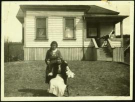
Fourteen year old Violet stands behind her mother who is seated on chair in front of house at South Fort George. Nine year old Arthur Taylor can be seen sliding down the front steps in background. Handwritten annotation on recto of photograph: "Mother & I and Arthur".
Hermina stands beside four women in front of wood house. Cake stands on short stool in foreground. Handwritten annotation on recto of photograph: "This is for dear Freddy, with love and thanks for all the letters and reports & cards you have sent to me. Lovingly Grannie. Grannie, Betty Angus, Donna, cake, Mrs. Gillies, Aunt Marge [wife of Tom Taylor]."
File contains slides depicting the opening of the Cottonwood Park section of the Heritage River Trails in Prince George, B.C.
Photographs depict groups of men gathered on ice. Herbert leans over behind two friends seated on ice sled (son of Marion and Archdeacon W.H. Collison). Pile of caught fish can be seen in foreground behind large whole in ice.
Handwritten annotations on verso read: "Oolichan Fishing Fishing Bay Nass River"; "Uncle Herbert with Indian friends fishing for oolichan through the ice."
Image depicts numerous buildings in Hendrix Lake, B.C.
Photograph depicts row of houses behind trees. Power line, road, and vehicles in foreground; mountain in background.
Photograph depicts row of houses behind trees. Road, front yards, and vehicle in foreground, mountains in background.
Photograph depicts two unidentified men entering building with the sign "THE ROYAL BANK OF CANADA" above main entrance. Photographer with tripod in foreground.
Photograph depicts plant buildings below, tailings pile in foreground. Valley and mountains in background. Handwritten annotation on recto of photograph: "CASSIAR".
Photograph depicts plant buildings in front of tailings pile in midground. Forest, power line, and tramline in foreground; south mountains in background.
Photograph depicts crusher plant in centre foreground. Shifter shack and vehicles can be seen in front of pit area. West Peak semi-visible in right midground. Mine valley an northwestern mountain range in background.
Photograph depicts the headquarters and general offices of the National Harbours Board in Vancouver, B.C., located at the foot of Dunlery St.
Image depicts the public library in Hazelton, B.C.
Image depicts the cemetery in Hazelton, B.C.
Image depicts a tombstone in the cemetery in Hazelton, B.C.
Image depicts the cemetery in Hazelton, B.C.
Image depicts Hazelton, B.C.
Photograph depicts Hat Creek Staging Hotel, 7 miles north of Cache Creek. The hotel buildig were now part of a farm and contained stores, a cookehouse, and a dormitory.
Image depicts the welcome sign of the historic Hat Creek Ranch site north of Ashcroft, B.C.
Image depicts the road leading to the historic Hat Creek Ranch site north of Ashcroft, B.C. Several individuals are sitting on the front porch of the Ranch house.
Image depicts the front of the ranch house on the historic Hat Creek Ranch site north of Ashcroft, B.C.
Image depicts the Ranch house on the historic Hat Creek Ranch site north of Ashcroft, B.C.
Image depicts several individuals sitting on the front porch of the Ranch house on the historic Hat Creek Ranch site north of Ashcroft, B.C.
Image depicts numerous individuals standing near the Ranch house and McLean Cabin on the historic Hat Creek Ranch site north of Ashcroft, B.C.
Image depicts an old barn on the historic Hat Creek Ranch site north of Ashcroft, B.C.
Image depicts the McLean Cabin, built in 1861, which belonged to a retired Hudson's Bay Chief trader named Donald McLean, who was shot and killed while part of a posse that was searching for the murderers of a survey party. It is located at the historic Hat Creek Ranch site north of Ashcroft, B.C.
Image depicts a "box barn" on the historic Hat Creek Ranch site north of Ashcroft, B.C.
Photograph depicts the yard at the Hat Creek Ranch. Hat Creek used to be a staging post on the Cariboo Road.
Image depicts a neighbourhood on the Hart Highway in Prince George, B.C.
Image depicts Glenview Drive near the Hart Highway in Prince George, B.C.
File consists of clippings, notes, and reproductions relating to the house of Harry G. Perry, a politician and founding community member of Prince George. Includes: "Heritage site inventory" typescript document (1988); "Heritage advisory committee minutes" reproduction of a typescript document (13 Nov. 1980); "Application to rezone lots" typescript document from the City of Prince George (3 Mar. 1982); "By-law No. 3631" typescript document from the City of Prince George (24 Nov. 1980); "Minutes" typescript document from the Prince George and Fraser-Fort George Regional District Heritage Advisory Committee (13 Nov. 1980); "The Carter House" typescript letter from the Heritage Advisory Committee to the City of Prince George (21 Sept. 1979); and "RE: Status Report" typescript document from the City of Prince George to the Joint Heritage Committee (9 Sept. 1980). Also includes architectural drawings depicting plans for building the Carter house at 1850 Tenth Ave, Prince George (1979).
Elevated view of the buildings along the Prince Rupert shore, including the Prince Rupert Inn. The waterfront and some small islands can be seen in the background. Printed annotation on recto reads: "Harbour, Prince Rupert, B.C. 1658."
Boats, docks, ships and a large building in waterscape. Printed annotation on recto reads: “Prince Rupert B.C.” Handwritten annotation in pencil on verso reads: “McRae Bros”.
View of building, dock, harbour and small islands with snow peaked mountains in background. Printed caption on verso reads: “Port Essington B.C. Photo by P. E. Fisher”. Handwritten annotation in ink on verso reads: “up the Skeena”, in pencil on verso: “Port Essington, North Coast Commercial Coy”.
Image depicts the Hansard railroad bridge looking west. Map coordinates 54°04'37.9"N 121°50'46.3"W
Image depicts the Hansard railroad bridge taken from the new Hansard vehicle bridge. Map coordinates 54°04'58.1"N 121°50'58.0"W
Image depicts the new Hansard Bridge. Map coordinates 54°04'57.9"N 121°51'10.1"W
Photograph depicts a building that was believed to have had many usess, its last being a fish store.
Image depicts a man and woman shaking hands in a building at an uncertain location, possibly in Cottonwood Park. The man standing behind the two is possibly Elmer Mercier, a former mayor of Prince George, B.C.
Photograph depicts Hamilton St. in Vancouver, looking northeast.
Street scene showing people, dog, team of horses & wagon. Signage reads: “Beds; Mecca Café; Hardware.” Printed annotation on recto reads: “Hamilton Avenue, South Fort George, B. C. No. 110.” Verso displays cancelled 1 cent Canadian Postage Stamp and handwritten message in ink is addressed to Mr. Eathan Villard Burt Mish, U.S.A.
View of 5 buildings and 4 tents on land that has been cleared to stumps. Printed annotation on verso reads: “HAMILTON AVE. FORT GEORGE”, added handwritten annotation in ink reads: “1910”.
The photograph depicts a hallway with windows at the interior of the CN roundhouse in Prince George, BC. Reproduction of photograph from 1984.
Image depicts a hallway in an unknown building somewhere in Wells, B.C.