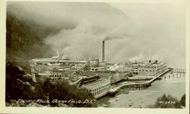
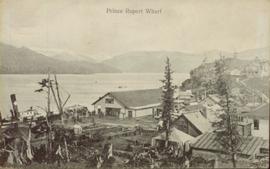
Lofty view of the buildings along the Prince Rupert wharf with workers unloading a vessel. Water and mountains can be seen in the background. Printed annotation on recto reads: "Prince Rupert Wharf."
Machinery visible in background.
Handwritten annotations on verso read: “Stewart, B.C.,” and “Bottom: at Granduc Copper mine with Mary Schindel, I drove the ‘Mitzie’”.
Machinery visible in background.
Handwritten annotation on verso reads: “John Lundquist, Mary Schindel”.
Photograph features Terrace Gardens.
Photograph depicts a line of men standing on opposite shore and holding a long rope between them, while men on scow float close to shore in distance. River water in foreground, trees on shore in background. Handwritten photo caption on verso and recto of this photograph reads: "In the Grand Canyon."
Photograph depicts a crew of 13 men on a scow believed to be maneuvering through the Upper Fraser River at Scow's Last Lap (Scow Rapids), downriver from the Grand Canyon of the Fraser. Trees on opposite shore in background, rocky shore in foreground. Handwritten annotation on recto of photograph reads: "the last lap".
Photograph depicts the Giscome Rapids. Opposite shore in background, rocky beach in foreground. Handwritten photo caption on verso and recto of this photo reads: "Point where G.T.P. [Grand Trunk Pacific] canoe capsized at Giscome Rapids & where 3 men were drowned."
Photograph depicts men standing near three covered wagons pulled by team of horses on street. Buildings line the street on left behind trees with protective structures built around their trunks. A windmill stands near small building and woodpiles in background on right. Trees on hill are visible in distance. Handwritten annotation on recto of photograph: "Quesnel".
Photograph depicts one man seated in rear of canoe on still water. Trees on opposite shore in background. This man is believed to be a member of the Bourchier forestry crew.
Photograph depicts group of men seated on scow carrying unidentified material. One man stands on rocky shore in left foreground, leaning on plank attached to scow. A second scow can be seen behind men. Tree-covered hills on opposite shore in background.
Photograph depicts men walking among stumps and log piles in forest clearing of the railway right-of-way.
Photograph depicts man standing among six snow-covered buildings in what is believed to be a railway construction camp. Power line in foreground, forest trees in background.
Photograph depicts dog standing next to man smoking pipe and leaning against large snow bank (snow stands taller than man). Power lines connect to wood building standing in background. Photograph believed to have been taken in railway construction camp.
Photograph depicts railway crossing in front of tent buildings. Dirt road in foreground, forest trees in background. Photograph speculated to have been taken in a construction camp at Prince George.
Photograph depicts lane in front of tent buildings flooded with water, forest trees in background. Photograph taken from canoe, portion of canoe visible in foreground. It is believed that this photograph may depict the Island Cache in flood, at Prince George, BC.
Photograph depicts lane in front of tent buildings flooded with water. Tree in midground, forest trees in background. A man can be seen between first and second row of tent buildings. Photograph taken from canoe, portion of canoe visible in right foreground. It is believed that this photograph may depict the Island Cache in flood, at Prince George, BC.
Photograph depicts two unidentified men standing and sitting at campfire by large fallen trees. Forest and mountains in background. Handwritten annotation on negative: "[?] Taken Near Kopoka".
Image is one of 65 photos documenting a survey of the Canada-Alaska Boundary, Taku River area, May 23 to Oct. 15, 1906.
This particular photo is one of 8 found in original enclosure with the following handwritten annotation: "From main camp up Kopoka River. Scenes with persons in." See also items 2006.20.3.14 - 2006.20.3.21.
Photograph depicts unknown man standing in water while pulling loaded canoe by rope. Rocky shore in foreground, mountains in background. Handwritten annotation visible on negative: "[?] hauling canoe. Big [?], Kopoka".
Image is one of 65 photos documenting a survey of the Canada-Alaska Boundary, Taku River area, May 23 to Oct. 15, 1906.
This particular photo is one of 8 found in original enclosure with the following handwritten annotation: "From main camp up Kopoka River. Scenes with persons in." See also items 2006.20.3.14 - 2006.20.3.21.
Photograph depicts three unknown men standing in water while pulling loaded canoe by rope. Rocky shore and hills in background. Illegible handwritten annotation visible on negative: "...[K. River]?" (Kopoka?)
Image is one of 65 photos documenting a survey of the Canada-Alaska Boundary, Taku River area, May 23 to Oct. 15, 1906.
This particular photo is one of 8 found in original enclosure with the following handwritten annotation: "From main camp up Kopoka River. Scenes with persons in." See also items 2006.20.3.14 - 2006.20.3.20.
Photograph depicts man [Gilroy?] sitting with small tin cup. Canoe lies upside down in foreground. Water and opposite shore visible in background. Handwritten annotation visible on negative: "Camp. [Gilroy?] on way up from trail. 9 pm".
Image is one of 65 photos documenting a survey of the Canada-Alaska Boundary, Taku River area, May 23 to Oct. 15, 1906.
This particular photo is one of 13 found in original enclosure with the following handwritten annotation: "SOME OTHERS." See also items 2006.20.3.22 - 2006.20.3.34.
Photograph depicts two unidentified men standing to right of flag mounted in rock pile.
Image is one of 65 photos documenting a survey of the Canada-Alaska Boundary, Taku River area, May 23 to Oct. 15, 1906.
This particular photo is one of 13 found in original enclosure with the following handwritten annotation: "SOME OTHERS." See also items 2006.20.3.22 - 2006.20.3.34.
Photograph depicts unknown men standing with walking sticks, carrying large bundles on their backs. Water and opposite shore in background, mountains visible in distance. Handwritten annotation visible on negative: "Billy [Gilroy?] & [?] packed for [?]".
Image is one of 65 photos documenting a survey of the Canada-Alaska Boundary, Taku River area, May 23 to Oct. 15, 1906.
This particular photo is one of 13 found in original enclosure with the following handwritten annotation: "SOME OTHERS." See also items 2006.20.3.22 - 2006.20.3.34.
Photograph depicts group of six men standing and sitting in forest in front of tent structure with log base. Handwritten annotation visible on negative: "[Myself?] Main Camp".
Image is one of 65 photos documenting a survey of the Canada-Alaska Boundary, Taku River area, May 23 to Oct. 15, 1906. This particular photo is one of 9 found in original enclosure with the following handwritten annotation: "Pictures of different members of ‘our’ party.” See also items 2006.20.3.57 - 2006.20.3.65.
Group of five miners stand in mining area on left. Woman, man, and young girl sit and stand on far right in more formal attire. Mining tools and equipment throughout.
Printed annotation on recto of photograph: "Société Minière de B.C., Atlin B.C. July 28th, 1901, A.C. Hirschfeld, No. 707".
Several large buildings on a rocky shore. Wood piles and a crane are visible in the background. Annotation on recto reads: "Prince Rupert BC"
Photograph of a large waterfront factory. Annotation on recto reads: "Pacific Mills, Ocean Falls, BC. No. 2935."
Photograph of a large pile driver working on the waterfront at the foot of a forested slope. Printed annotation on recto reads: 'Pile-driver working on Government Wharf Hughes #55."
Side perspective photograph of a Portland Canal Short Line engine being either loaded or unloaded by several men at the station in Stewart, BC. Printed annotation on recto reads: "Aug 9 1911 Stewart BC."
Three men can be seen on deck of small boat. Rocky shore in foreground, forest and hills on opposite shore in background.
Handwritten annotations on verso read: "Dad - en route up Nass River on official business. (hence the flag & business suit!)"; "Going up the Nass. Dad (Indian Agent) Cap Barry (Inspect. of Schools) travelling up the Nass River to Aiyansh".
Photograph depicts pipeline construction for the Pacific Northern Gas pipeline from Summit Lake to Kitimat.
Photograph depicts a construction site for the Pacific Northern Gas pipeline from Summit Lake to Kitimat.
Photograph depicts Iona Campagnolo standing and examining a document with an unidentified union worker (possibly a member of the BC Ferry and Marine Workers Union) in either Prince Rupert or Kitimat. Two unidentified men are in the foreground.
Image depicts Upper Fraser residential area during demolition of town site. Map coordinates 54°06'51.6"N 121°56'26.3"W
Image depicts a loading truck at the Gibraltar mine site north of Williams Lake, B.C.
File consists of a transcript of an oral history interview with Mr. and Mrs. Cox.
Handwritten annotation on recto of photograph: "POURING RIBS JUNE 29/64." Photograph depicts construction workers on large wooden framework structure extending from base of crusher building. Ladders stand parallel to structure against mountainside. The boom of a crane is visible in foreground. Miscellaneous construction equipment and materials throughout.
Photograph depicts two pick hammers laid in asbestos fibre. Annotations on note glued to recto of photograph: "ASBESTOS"; "Detail view of asbestos talus. Early test pit near top of showing. Western slope." Areas of image have been labeled "A" and "B". Photo caption under printed copy of image in 1952 Annual Report: "A - Asbestos fibre partially opened by frost action. B - Serpentine rock originally containing the asbestos fibre."
Photograph depicts a man and woman standing on what is believed to be an early mining bench. Two men with air track drill can be seen in background, one man father down on left, mountain range in background. Image slightly distorted due to poor quality of negative.
Photograph depicts two men working with air track drill in mine area. Hose and dynamite box in foreground, mountains in background. Handwritten annotation on verso of photograph: "Sept. 1954." This photograph was originally stored inside duotang labeled "CASSIAR ASBESTOS CORPORATION LIMITED PHOTOGRAPHS 1954"; photo caption beneath this image: "Starting New Bench at South end of Deposit."
Photograph depicts unknown man driving bulldozer on edge of mine area at high elevation. The dozer is an International model TD24 (manufactured between 1947 and 1955). A second man stands on edge of cliff, directing driver. Expansive mountain range in background.
Photograph depicts an unidentified individual wearing a welding helmet, and kneeling behind large bearing cups of one of the Ruston Hornsby diesel engines that turned the generators in the power house on the Cassiar plant. Door, bulletin board, and miscellaneous supplies in background.
Photograph depicts a car and two dump trucks near a small garage by road in mine. One man stands at garage site among tires and miscellaneous tools. Blasthole drills, shovels, and dump trucks visible in distance. Rocks in foreground, mountains in background. Handwritten annotation on verso of photograph: "1961".
Photograph depicts men standing near two Atlas Copco Drillmasters (blasthole drills). These are precision hammer drills which had their own power source. Large bags of ammonium nitrate in foreground, mountaintops in background. The men depicted here were likely members of the explosive crew. It is believed that this photo was taken on the North ridge, near the cirque dump. Handwritten annotation on verso of photograph: "1961".
Photograph depicts man [possibly Paul Clark?] seated with two women at table in lab. Second man [possibly Lab Superintendent Ross Duddy?] seated at table in background. Miscellaneous equipment and supplies throughout. Handwritten annotation on recto of photograph: "Paul Clark / [Odett?] Cario".
Photograph depicts two women seated at lab table, facing away from photographer. Woman on right believed to be combing asbestos fibres to determine length and grade. Woman on left believed to be conducting standard lab tests (weighing filters, test tubes, or fibres).
Photograph depicts group of ten men standing and kneeling in front of BE 40R blasthole drill in mine area. For names of individuals, see similar image, item 2000.1.1.3.19.72.
Photograph depicts group of ten men standing and kneeling in unknown location at the Cassiar mine. Handwritten annotation on recto of photograph: "APPROX 1965 / BACK L-R / 1.- / 2. Don Erwin [i.e Irwin] / 3. MAC MAcCLOUD DIED 1979 / 4. JIM MURDOCK MINE SUPER / 5. RUPERT McKENZIE CAPT / 6. DANNY DEMETRI / 7. VIC SARAKOSKI / FRONT. L-R / 1. DON HUDGEON / 2. MIKE CLARK / 3. - [Adrian VanHill Sr.]". Information in above annotation supplemented with insight from individuals who contributed to Northern BC Archives Facebook Photo ID Project, contact archivist for more information in research file pertaining to this photograph.
Photograph depicts unidentified man at orange lockers in the new Mine Dry change house. This building also housed a security office, and mine store where work apparel could be purchased (see item 2000.1.1.3.19.124).
Photograph depicts group of unidentified men seated in bus seats, wearing work clothes and hard hats. Believed to be taken on mine bus which ran between the plant and mine (see also item 2000.1.1.3.19.70).
Photograph depicts part of the vacuum dust control and removal system in the Cassiar mill building. Unidentified man can be seen at rotary air-lock, in which heavy blown dust would collect before dropping to plenum conveyor resting just above floor. From here, the dust would eventually be expelled at the tailings pile outside of the mill. Second unidentified man can be seen climbing steps in background. This section of the mill was located above the lab.