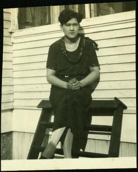
Violet sits on wood ladder leaning against siding of house. She is wearing a skirt, blouse and scarf. Bottoms of windows are visible above and behind her.
Violet (nee Taylor) Baxter stands in snow beside Bob's sister Bea. Two buildings are semi-visible behind trees in background. See item 2009.5.4.29 for image of Bob and Bea.
Postcard overview of the Bulkley River running closely past the village of Telkwa. Handwritten annotation in pen on verso reads: "Don Choracy [?] Prince Rupert, B.C. c/o Wrathall's Photo Shop. Aug. 9 Lake Kaetlyn. We had to drive all the way to Telkwa the other nite for postcards, imagine. We were sure glad and surprised to see Jack & Dick drive in at 7 to-nite. Just like being home. We are having so much fun. The boys are out on Lake to-nite, went to visit Dr. Macdonald's me thinks. I have bad head cold so have to stay home first nite at home I've since we came, Dieks is taking me on Lake tomorrow I hope, Love Bea-P."
Photograph depicts community buildings on shoreline, water in foreground.
Handwritten annotation on image reads: "Wrangle, Alaska."; on verso: "Fort Wrangle, Alaska Territory. visited by W.H.Collison, C.M.S. 1877. Prior to the establishment of any mission, [...? illegible] 1875 - 1876. Presbyterian. Insert this illustration of Wrangle on Page 77 as marked."
Photograph depicts a view looking northeast towards Coal Harbour from Alberni St. (Chilco-Gilford block) with West Georgia St. in the middle distance.
Photograph depicts a small building in low valley, tall hills in background, trees in foreground.
Photograph depicts the north shore of False Creek, looking west after a snowfall. Photo taken from the swing span of Cambie Bridge in Vancouver, B.C.
Photograph depicts a view of the Fraser River from the Albion Ferry from Haney to Fort Langley. The ferry is approaching the south bank of Fort Langley. Gulls sat on logs floating downstream; too heavy to rise after eating candlefish.
Photograph depicts the Agora center at the University of Northern British Columbia in Prince George, B.C. Library building can be seen in right background, cafeteria building on far left. Unidentified individuals can be seen walking on campus. Accompanying note from Maureen Faulkner: "The processional gathers on the upper walkway". Photo believed to have been taken on the day Bridget Moran received an Honourary Law Degree.
Photograph depicts the Agora center at the University of Northern British Columbia in Prince George, B.C. Sign in foreground reads "Agora/Student Centre". Unidentified individuals can be seen in red blankets on upper walkway in background, above the Winter Garden. Accompanying note from Maureen Faulkner: "The first nations people, in button blankets, gather". Photo believed to have been taken on the day Bridget Moran received an Honourary Law Degree.
Photograph depicts the rear and side view of the abandoned Sumas electrical substation on the B.C. Electric Railway at Vedder Mountain.
Photograph depicts a row of houses and fenced yards on right, separated from more buildings on left by grassy area.
Printed on image: "Metlakahtla Nr. Prince Rupert. Allen Photo June '11"; handwritten annotation on verso reads: "Metlakatla B.C. North West Coast of America / Collison".
View of the road descending to the waterfront. Buildings and forested area are visible on either side of street. Mountains clear in the background.
Winter scene with buildings, street, and utility poles. Hill in background.
Handwritten annotation on verso: “South Ft. George 1912”.
Image depicts a view of Quesnelle Forks and the nearby river.
Lofty view of Prince Rupert BC. Water crosses midground, hills stand in background. Printed annotation on recto reads: “Prince Rupert BC McRae Bros”.
Lofty view of Prince Rupert BC. Water crosses midground, hills and opposite shore in background. Printed annotation on recto reads: “Prince Rupert BC McRae Bros”.
River crosses midground, hills on distant shores can be seen in background.
Handwritten annotation on verso reads: "No. 32, First Beginning Prince Rupert, showing Church Hall, with cross. Insert Page 136".
Winter landscape taken from behind railroad track. Cleared land in foreground, buildings in midground, low hills in background.
Handwritten annotation on recto: “PRINCE GEORGE 3-15-14”.
Winter landscape taken from behind railroad track. Cleared land in foreground, buildings in midground, low hills in background.
Handwritten annotation on recto: “PRINCE GEORGE 3-15-14”.
River in foreground, railroad and city in mid ground and hill in background. Printed annotation on recto reads: “Prince George. B.C. 1924”
Boardwalk in foreground, buildings and roads in mid ground, cut banks in background. Printed annotation on recto reads: “Prince George. B.C. 1921 by Moore”. Handwritten annotation in ink on verso reads: “The Netchaco river is between the mountain and the city and the C.N.R. runs along the river bank nearest the city. This picture is taken looking north.”
Image depicts the Grand Trunk Railway bridge across the Fraser River. Map coordinates 53°54'29.0"N 122°42'06.5"W
Image depicts a view of Prince George from Cranbrook Hill looking southeast. Map coordinates 53°54'51.5"N 122°49'05.2"W
Image depicts a view of Prince George from Cranbrook Hill looking east. Map coordinates 53°54'51.5"N 122°49'05.2"W
Image depicts a view of Prince George from Cranbrook Hill looking southeast. Map coordinates 53°54'51.5"N 122°49'05.2"W
Image depicts a view of Prince George from Cranbrook Hill looking east with pulpmill and downtown in background.
Image depicts a view of Prince George from Cranbrook Hill looking east. Map coordinates 53°54'51.5"N 122°49'05.2"W
Image depicts a view of Prince George from Cranbrook Hill looking east.
Image depicts a view of Prince George from Cranbrook Hill looking southeast. Map coordinates 53°54'51.5"N 122°49'05.2"W
Image depicts a view of Prince George from City Hall looking north. Map coordinates 53°54'46.3"N 122°44'41.9"W
View of pier, cluster of houses and trees with snow topped mountains in background. Handwritten annotation on verso reads: “Hospital” with an arrow pointing to the building. Postage cancelation stamp on verso reads: "PORT ESSINGTON B.C. JUL 7 07". Handwritten annotation on recto reads: “PORT SIMPSON. Mrs. Noble Port Essington B. C. Hope you are feeling better. I am doing splendidly have not felt so well for years. Dr. advises me to stay at least another month A.W.B.”
Photograph depicts Port Simpson in winter. Water crosses midground, hills stand in background.
Handwritten photo caption below image reads: "Port Simpson".
Photograph depicts shore and village with a treed hill in the background. Water and boats in foreground. Handwritten annotation in ink on verso of photograph: "Port Simpson B.C.". Semi-legible annotation on recto notes the postcard was addressed to London, England.
Photograph depicts buildings along shore; bridge and boardwalk cross forest in right foreground. Hills visible in distance.
Handwritten annotation below image reads: "Port Essington from bridge"; on verso: "Heading or full page Illustration Chapter XXIII No2".
Town on right, water on left, mountains in background. Forest trees in foreground.
Handwritten photo caption below image reads: "Port ESSINGTON".
Handwritten caption beside this photo reads: "View of Pinion & three sections of Crusher". Red rectangular equipment stands enclosed in wood frame, which is also enclosed in the much larger steel frame of the crusher building. Traveler crane on right.
Image depicts a view of the small town of Likely, B.C.
Image depicts a view of Giscome with a train passing through.
Photograph depicts road at University of Northern British Columbia. Library building stands in center background. Administration and cafeteria buildings can be seen in left background. Accompanying note from Maureen Faulkner: "Walking up to Canada's newest 'U' - ". Photo believed to have been taken on the day Bridget Moran received an Honourary Law Degree.
View of town on shore, from above. Boats docked along piers and buildings. Hills visible on either side of water in background.
Handwritten photo captions with arrows pointing to sections of image read: "General Merchandise", "Fort Wrangell Hotel".
Lofty view of South Fort George, river and treed hills in the background. Printed annotation on verso reads: “South Fort George - 1913.” Handwritten message on recto is addressed to “Ethel M. Heurris Norton Maps Bristol County" reads: "11-1-13 an excellent view of south Fort George taken recently. Power Station at cross near water. This does not give all the south residence view. Population approx 1500”.
Lofty view of Fort George, B.C., river and paddle wheeler on right. Treed hills can be seen in background. Printed annotation on verso reads: “Fort George B. C.”
View of Cluster of buildings with treed hill in the background. Printed annotation on verso reads: “NEAR FORT GEORGE B.C.”
Hand coloured view of early Prince Rupert with row of tents facing large Hotel. Printed annotation in red ink on recto reads: “The Beginning of Prince Rupert B.C.: Grand Trunk Pacific Hotel in foreground”.
Image depicts downtown Prince George taken from across the Nechako River looking south. Map coordinates 53°56'00.0"N 122°44'29.7"W
One man can be seen on crusher building framework, unidentified equipment and long metal rods in foreground. Power lines, a large tank, and other small buildings are semi-visible on a level in the mountainside just above the crusher building. Sky can be seen in background.
Men can be seen working on site. Crusher building in midground, chutes can be seen crossing the different levels of foundation. Lumber is leaning against excavated dirt wall in foreground, as well as a ladder which reaches up to the base level. Large tank can be seen in top level above building construction. Mountaintop and sky in background.
View showing various levels of foundations. Men can be seen working on site. Vertically protruding planks from framework in foreground. A long building believed to be housing conveyor "B" can be seen in background, as well as the tree-covered valley.