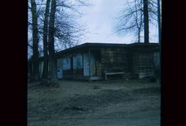
Image depicts a stand of trees and a shed at Island Cache.
Image depicts what is likely an outhouse at Island Cache.
Image depicts a clearing at Island Cache.
Image depicts a grocery store at Island Cache.
Image depicts a house in Island Cache. There are several cars parked outside it.
Image depicts a boarded up building in Island Cache.
Image depicts two children standing near an old car in Island Cache.
Image depicts a number of sheds in Island Cache.
Map reproduction of the Aleza Lake Research Forest depicts timber sale areas, forest cover, and other details.
Image depicts the slopes of Tabor Mountain in Prince George, B.C.
Map reproduction of the Sinclair Spruce Lumber Co. Ltd. T.S.H.L. A01848 C.P. 310 cutting area, likely in the Aleza Lake Research Forest.
Image depicts numerous skiers standing near a finish line somewhere on Tabor Mountain in Prince George, B.C.
Image depicts a view of Prince George from the cutbanks.
Image depicts a cutbank on the Nechako River in Prince George, B.C.
Image depicts the Fraser River from the vantage point of the cutbanks in Prince George, B.C.
Image depicts a view of Prince George from the cutbanks on the Nechako river.
Image depicts part of the McMillan Creek Trail in the McMillan Regional Park in Prince George, B.C.
Image depicts part of the McMillan Regional Park in Prince George, B.C.
Image depicts the McMillan Creek from Northwood Pulpmill Road, in Prince George, B.C.
Image depicts a farmhouse on Old Summit Road in Prince George, B.C.
Image depicts a view of the Fraser-Nechako confluence from the Prince George cutbanks.
Image depicts a small slope on Carney Hill in Prince George, B.C.
Image depicts Cottonwood Island.
Image depicts a small stream somewhere on Cottonwood Island.
Image depicts two youths fishing from the bank of the Nechako River on Cottonwood Island.
Image depicts what is possibly a small section of the Nechako River on Cottonwood Island.
Image depicts the Fraser River and the Grand Trunk Pacific Bridge from Cottonwood Island Park.
Image depicts Prince George at night from the cutbanks.
Image depicts the Nechako River on Cottonwood Island.
Image depicts a horse on Cottonwood Island.
Image depicts the Nechako River from Cottonwood Island.
Image depicts a green car among some trees on Cottonwood Island.
Image depicts a nature trail on Cottonwood Island.
Image depicts Cottonwood Island.
Image depicts a small stream somewhere on Cottonwood Island.
Image depicts a nature trail on Cottonwood Island.
File is a Resource Folio of maps and accompanying information created by Northwood Pulp & Timber regarding Timber Sale Harvesting Licence A01847, Willow River Block, Willow River P.S.Y.U. Includes maps that depict ungulates, waterfowl, recreation areas, special influence areas, and timber types. Most of the sheets have a duplicate, some with very slight variations. The following maps are supposed to be included in the but were missing upon arrival at the Archives: fish & topography, cutting permits & roads, and soils.
Image depicts a Beehive Burner along the Nechako on River Road. Map coordinates 53°55'34.1"N 122°44'58.0"W
Image depicts an example of varves, an annual layer of sediment or rock, with a pipe used for reference size. It is possibly located at the airport in Prince George, B.C.
Image depicts sand beds with a shovel present for size reference. The slide places it at the "BCR site," possibly in Prince George, B.C.
Image depicts numerous skiers on the Birchleg Ski route on Tabor Mountain in Prince George, B.C.
Image depicts numerous skiers cross-country skiing on a trail through trees on the Birchleg Ski route on Tabor Mountain in Prince George, B.C.
Image depicts a view of the area around Tabor Mountain in Prince George, B.C.
Image depicts numerous skiers and skis that are standing upright in in the snow on Tabor Mountain in Prince George, B.C.
Image depicts the Pearson Homestead.
Image depicts a rural setting, most likely near the airport in Prince George, B.C.