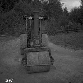
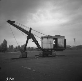
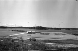
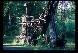
Photograph depicts a derelict shovel beside the coaling wharves at Union Bay.
Photograph depicts a Ruston steam roller owned by Gary Wellburn in Duncan, BCIt was previously owned by the Oak Bay municipality.
Photograph depicts a steam crane at the Allied Shipbuilders Ltd. on 145 West First Ave in Vancouver, BC
Photograph depicts an old pelton wheel at a former quarry at Granite Falls on the northeast head of the Indian Arm.
Photograph depicts a shipping terminal in Prince Rupert. Shipping containers are in the distance.
Photograph depicts a shipping terminal in Prince Rupert. The ocean is visible in the background.
Photograph depicts the "Ocean Gem" fishing boat at the Prince Rupert marina. The Prince Rupert Fisherman's Co-operative Assocation Building is visible in the background.
Photograph depicts the an unidentified fishing boat at the Prince Rupert marina.
Photograph depicts the "Northern Dawn" and the "Comanchero II" at the Prince Rupert marina.
Photograph depicts the "Little Current" and other boats at the Prince Rupert marina.
Photograph depicts a hoist and many unidentified boats at the Prince Rupert marina.
Image depicts what appears to be a part of the old, abandoned mill in Lamming Mills, B.C.
Image depicts Upper Fraser mill yard with log deck and beehive burner in silhouette across railroad tracks. Located in Upper Fraser, B.C. Map coordinates 54°07'01.5"N 121°56'29.6"W
Image depicts numerous log decks at the Upper Fraser sawmill. Map coordinates 54°07'10.8"N 121°56'51.7"W
Image depicts the mill site at Giscome, B.C. Map coordinates 54°04'19.7"N 122°22'04.7"W
Image depicts an aerial view of areas that have been used for logging around Prince George, B.C.
Image depicts a highway, and a section of mountain in the background which is bare due to clear-cut logging. It is possibly somewhere near Prince George, B.C.
Image depicts a logging area, and a section of mountain in the background which is bare due to clear-cut logging. The slide is also labelled "logging show." It is possibly somewhere near Prince George, B.C.
Image depicts a saw mill, possibly Lakeland Mills, with a beehive burner and numerous piles of logs in the foreground, in Prince George, B.C.
Image depicts a trailer for a logging truck suspended off the ground by a wooden structure. This is used to load the trailer onto the back of the truck. The name on the truck says "Rormarniewich Trucking Ltd."
Image depicts logs being stripped of their bark at a saw mill in Prince George, B.C.
Image depicts machinery in a saw mill somewhere in Prince George, B.C.
Image depicts wood planks in the interior of a saw mill somewhere in Prince George, B.C.
Image depicts a piece of heavy machinery lifting numerous logs off the back of a logging truck. It is likely located in Prince George, B.C.
Image depicts the Northwood pulpmill in Prince George B.C.
Image depicts Prince George, possibly with the Northwood Pulpmill in the background.
Image depicts the Northwood Pulpmill in Prince George, B.C. taken from above the Nechako River looking east. Map coordinates 53°56'00.0"N 122°44'29.7"W
Image depicts a piece of industrial machinery, likely for either mining or forestry, in an uncertain location near McLeod Lake, B.C.
Image depicts Prince George from University Way, with the P.G.I pulp mill in the distance.
Image depicts a Hydraulic Placer mining location in Barkerville which has been completely deforested.
Image depicts a river full of logs, somewhere near Bralorne, B.C.
Image depicts the Bridge River No. 1 hydroelectric station on the shore of Seton Lake (rear side of powerhouse).
Image depicts a sawmill in Prince George, B.C.
Image depicts a large, old piece of machinery, possibly some form of mining or prospecting equipment; it is located in Quesnelle Forks, B.C.
Image depicts several unknown individuals present as a piece of machinery is used to assist in the mining of gold at Mosquito Creek in Wells, B.C.
Image depicts a man using a piece of machinery for the mining of gold at Mosquito Creek in Wells, B.C.
Image depicts the site of Giscome's first quarry, with a train passing by and Eaglet Lake located in the foreground.
Image depicts what is likely the Dunkley Lumber Mill in Strathnaver, B.C.
Image depicts a sawmill somewhere in Quesnel, B.C.
Image depicts numerous wood piles near the sawmill somewhere in Quesnel, B.C.
Image depicts a sawmill somewhere in Quesnel, B.C.
Image depicts a drill for blasting holes at a mine site somewhere in Granisle, B.C.
Image depicts numerous bags of blasting powder at a mine site somewhere in Granisle, B.C.
Photograph depicts large square model of the new mill building that was built at the Cassiar plant site in 1970. Model is displayed outdoors on a platform that stands on four saw horses. Machinery modeled inside the structure is colour-coded. Plant buildings and mountains in background.
Photograph depicts large square model of the new mill building that was built at the Cassiar plant site in 1970. Model is displayed on platform draped with green material. Machinery modeled inside the structure is colour-coded.
File depicts a Caterpillar front end loader. Images show dozens of angles and a number of components including the shovel, the engine, the cab, and the tires. Machine seems to be located in some kind of junkyard. Notes on original photo envelope: "Photos taken by Finning during final inspection."
Photograph depicts the Cassiar townsite behind shadow in foreground. Plantsite can be seen including the mill, dry rock storage building, tailings pile, and many other buildings. Mountains in background. Handwritten annotation on recto: "<- 13 1/2" ->". (This photograph was made into a promotional poster.)
Photograph depicts the North peak of McDame mountain after extensive strip mining, South peak unmined in background. Old mine garage visible on right of West peak in foreground. Crusher plant partially visible on far right. Photograph believed to have been taken just prior to the development of the pit mine between the North and West peak.