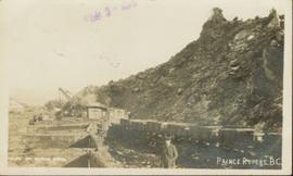
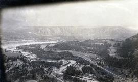
Postcard depicts the passage through the shoulder of Mt. Stephen.
Postcard depicts Mt. Stephen and Field, BC
Postcard depicts Kicking Horse Canyon.
Postcard depicts Mt. Stephen and Kicking Horse River.
Postcard depicts the Kicking Horse Canyon near Yoho National Park.
Photograph depicts unknown man standing in water while pulling loaded canoe by rope. Rocky shore in foreground, mountains in background. Handwritten annotation visible on negative: "[?] hauling canoe. Big [?], Kopoka".
Image is one of 65 photos documenting a survey of the Canada-Alaska Boundary, Taku River area, May 23 to Oct. 15, 1906.
This particular photo is one of 8 found in original enclosure with the following handwritten annotation: "From main camp up Kopoka River. Scenes with persons in." See also items 2006.20.3.14 - 2006.20.3.21.
Photograph depicts three unknown men standing in water while pulling loaded canoe by rope. Rocky shore and hills in background. Illegible handwritten annotation visible on negative: "...[K. River]?" (Kopoka?)
Image is one of 65 photos documenting a survey of the Canada-Alaska Boundary, Taku River area, May 23 to Oct. 15, 1906.
This particular photo is one of 8 found in original enclosure with the following handwritten annotation: "From main camp up Kopoka River. Scenes with persons in." See also items 2006.20.3.14 - 2006.20.3.20.
Photograph depicts unknown men standing with walking sticks, carrying large bundles on their backs. Water and opposite shore in background, mountains visible in distance. Handwritten annotation visible on negative: "Billy [Gilroy?] & [?] packed for [?]".
Image is one of 65 photos documenting a survey of the Canada-Alaska Boundary, Taku River area, May 23 to Oct. 15, 1906.
This particular photo is one of 13 found in original enclosure with the following handwritten annotation: "SOME OTHERS." See also items 2006.20.3.22 - 2006.20.3.34.
Photograph depicts two men standing on mountain with walking sticks, carrying bundles on their backs. Valley and mountains visible in background below. Handwritten annotation visible on negative: "[?] Climbing [?] Sta - K. River" (Kopoka?).
Image is one of 65 photos documenting a survey of the Canada-Alaska Boundary, Taku River area, May 23 to Oct. 15, 1906. This particular photo is one of 7 found in original enclosure with the following handwritten annotation: "Around River Taku and main camp on same." See also items 2006.20.3.35 - 2006.20.3.41.
Postcard depicts Mt. Stephen, Field, BC
Postcard depicts Kicking Horse Canyon near Mt. Field.
Item is a print of a photograph of a person poling a dugout canoe between 1906 and 1908.
Photograph depicts unknown man in canoe, opposite shore and hills in background.
Image is one of 65 photos documenting a survey of the Canada-Alaska Boundary, Taku River area, May 23 to Oct. 15, 1906.
This particular photo is one of 8 found in original enclosure with the following handwritten annotation: "From main camp up Kopoka River. Scenes with persons in." See also items 2006.20.3.14 - 2006.20.3.21.
Postcard depicts the Canadian Pacific Railway line where the Great Divide between BC and Alberta.
Postcard depicts Castle Mountain found along the Canadian Pacific Railway line.
Postcard depicts one of the upper sprial tunnels in Field, BC
Postcard depicts a train entering a lower spiral tunnel. Mount Stephen visible.
Postcard depicts a lower spiral tunnel along the CPR line near Field, BC
Postcard depicts Kicking Horse Canyon.
View of Pier and cluster of houses with trees in the background. Water crosses midground, canoes on beach in foreground. Printed annotation on verso reads: “Port Simpson.", handwritten in pencil: “B.C. 1907”.
Photograph of a mustachioed man perched atop a cart load of lumber hitched to a team of horses. Annotation on recto reads: "First Team Hitched Up at Prince Rupert May 1908."
Side view photograph of a small harbor close by a shoreline littered in organic debris. A foggy mountain range is visible in the background. Annotation on recto reads: "Wharf and Harbor Prince Rupert. May 1908 JDA."
Elevated view of Third Avenue in Prince Rupert. What appears to be a firetruck is travelling down the road. Printed annotation on recto reads: "3rd Ave W Prince Rupert BC."
Street view of Third Avenue in Prince Rupert. Many vehicles are parked along the wooden sidewalk. Printed annotation on recto reads: "Third Ave. Prince Rupert. B.C."
Street view of Third Avenue in Prince Rupert. A large crowd of people is gathering along the sidewalks. Printed annotation on recto reads: "Third Ave. Prince Rupert. B.C."
Overhead view of the dry dock in Prince Rupert, BC. Printed annotation on recto reads: "Prince Rupert Dry Dock."
Ground level view of the Prince Rupert dry dock. Hills are visible in the background. Printed annotation on recto reads: "Three Million Dollar Dry Dock and Shipbuilding Plant, Prince Rupert, BC."
Water level photograph of several vessels docking in Prince Rupert. The "Co Op Fish Liver Oil" building is visible in the background. Printed annotation on recto reads: "Docks Prince Rupert."
Photograph of a small vessel on the ocean with a dock and harbour buildings in the foreground. Tents and piles of lumber can be seen among the buildings. Annotation on recto reads: "The Wharf, Prince Rupert, BC. 1657."
Photograph depicts the confluence of the Cayoosh Creek outflow into the Fraser River in Lillooet, BC. Seton River is visible in the foreground. This area is Cayoose Creek Band (Sekw'el'wás First Nation) territory and includes land currently encompassed within Cayoosh Creek Indian Reserve 1. The Pacific Great Eastern Railway bridge over the Fraser River is also visible in the background.
Collection of four photographs of the Prince Rupert dry dock. Printed annotation on recto reads: "Dry Dock and Ship Building Plant, Prince Rupert BC."
Ground level view of the Prince Rupert dry dock during what appears to be construction. Printed annotation on recto reads: "The Dry Dock of Prince Rupert."
Photograph of many fishing boats in a harbour. Printed annotation on recto reads: "Prince Rupert Halibut Fleet landing 500,000 LBS. WWW."
Water level photograph of several small vessels gathered around a large cold storage building. Printed annotation on recto reads: "Cold Storage, Prince Rupert B.C. 66."
Street view of Third Avenue in Prince Rupert, BC. Several cars are visible parked along the sides of the paved street. Printed annotation on recto reads: "Third Ave. W Prince Rupert- BC."
Photograph of two men in a car driving down a wooden road in Prince Rupert, BC. Printed annotation on recto reads: "First Motor Car in Prince Rupert, B.C., May 1909." Handwritten annotation on verso reads: "Milwaukee Ore. Nov 7 1913. Dear Friends. Just a line. We are comming[sic] over Sunday if it don't rain to[sic] hard. How is Fredie? Hope he is alright. If you had other plans for Sunday you can phone us. Best regards from us both. Mrs Ed Herry[??]." Postcard is addressed to: "Mrs. J Reichard 3404 34 L. St. Vancouver Wash." Verso is affixed with a one cent American stamp. Postmark reads: "Milwaukee [illegible] Oreg."
Elevated view of the buildings along the Prince Rupert shore, including the Prince Rupert Inn. The waterfront and some small islands can be seen in the background. Printed annotation on recto reads: "Harbour, Prince Rupert, B.C. 1658."
Elevated view of various buildings and vessels along the Prince Rupert waterfront. Several piles of lumber can be seen in the foreground. Printed annotation on recto reads: " Prince Rupert B.C., A busy day on the Waterfront."
Hand coloured side view of various buildings along the Grand Trunk Railway waterfront. Printed annotation on recto reads: "Prince Rupert, B.C. : View from Harbor Grand Trunk Pacific Railway." Artist's stamp on lower right corner reads: "103,113 J.V."
Photograph of the SS Camosun arriving in a harbour in Prince Rupert. A blurry man is in the lower right corner of the foreground. Another large vessel can be seen behind the Camosun. Annotation on recto reads: "SS 'Camosun' at Prince Rupert Allen Photo May 23[?]09."
Elevated view of Third Avenue in Prince Rupert. Signs for "Chris Mill Bakery" and "Overwaitea" are visible on the left side of photograph. Printed annotation on recto reads: "3rd Ave Prince Rupert BC."
Street view of Third Avenue in Prince Rupert. Printed annotation on recto reads: "60 Post office 3rd Ave Prince Rupert BC."
Street view of Third Avenue in Prince Rupert. Printed annotation on recto reads: "Third Ave Prince Rupert B.C. Photo W.W.W."
Street view taken from the intersection of Third Avenue and Sixth Street in Prince George BC. A drugstore and several cafes can be seen on the left side of the street. Printed annotation on recto reads: "3rd Ave & 6th Street Prince Rupert BC."
Photograph of many fishing boats in a harbour. Printed annotation on recto reads: "Fishing Boats Unloading at Prince Rupert, B.C."
Photograph of a line of rail cars along a track next to a blasted pile of rubble. Printed annotation on recto reads: "Photo by McRae Bros. Prince Rupert." Handwritten annotation on verso reads: "Hello Charly. I have been dead for 2 month and just woke up tell the folks out home I am doing[??] fine. don't know when I will be down again Remember me to the good little woman, and weave[??] all Well. you're[??] friend Stan C." Postcard is addressed to: "Mr. Charles Chislett 96 Colonist Printing Co. Broad Street Victoria B.C." Verso is affixed with a one cent Canadian stamp. Postmark reads: "Prince Rupert B.C. [illegible date]."
Lofty view of the buildings along the Prince Rupert wharf with workers unloading a vessel. Water and mountains can be seen in the background. Printed annotation on recto reads: "Prince Rupert Wharf."
Hand coloured photo of lumber piles and buildings along the edge of the railway. Printed annotation on recto reads: "Prince Rupert, B.C. : View from Wharf Grand Trunk Pacific Railway." Artist's mark in lower left corner reads: "103,110 J.V."
Government map depicts railway lands, lands "disposed of", grazing leases, and timber berths. Shows the British Columbia 'railway belt' running from Greater Vancouver to Field, B.C.
Side perspective street view of the Royal Hotel in Prince Rupert BC. The "Ladies [sic] Entrance" sign is visible on the right side of the building. Several vehicles can be seen on the street. Printed annotation on recto reads: " 3rd Ave Prince Rupert Photo W.W.W."