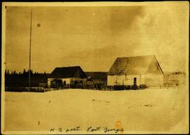
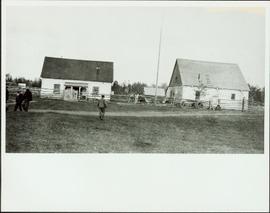
Photograph depicts two buildings behind fence, sheds visible in background. Unidentified men can be seen walking in foreground. Small structures believed to be teepees can be seen behind fence.
Photograph depicts four buildings behind wood fence. Cleared area in foreground, forest in background. Handwritten annotation on verso and recto of this photograph reads: "H. B. Post - Fort George".
Photograph depicts a group of buildings in distance behind fenced area. Field spans foreground and stand of trees in background. Handwritten photo caption below photograph reads: "H.B.C. Fort St. James ."
Image depicts the Britannia Mine, which closed in 1974 and is now a museum. "Anaconda" was the last operating owner.
Photograph depicts a few houses on Beach Ave., Vancouve. They were examples of about a dozen surviving homes on Beach Ave.
Image depicts a number of houses built on stilts over a body of water in an uncertain location.
View of peninsula with houses and trees. Dock in mid ground, trees and grasses in foreground. Recto stamped “Port Simpson DE 17" and "Port Essington DE 18". Handwritten annotation on recto of photograph: "W. J. O'Neill Esq. Telegraph Point Via Pt. Essington B.C. Don't you think this pretty [Weggs & Mr. Byron?] was over last night - said he saw you and [Halie?]. Yours - BaBa".
Image depicts houses on Dogwood Street in the Millar Addition neighbourhood of Prince George, B.C. On the left is 1610 Dogwood Street and 1630 Dogwood Street is the middle house; 1650 Dogwood Street is the blue house on the right.
Photograph taken looking northwest at a corner house and another home to its left. They were 2 of 9 houses in this Beach Block, the last block of houses on Beach Ave.
Image depicts a row of houses in Upper Fraser, B.C. Map coordinates 54°06'51.6"N 121°56'26.3"W
Image depicts the Giscome B.C. townsite from across the railroad tracks looking southeast. Map coordinates 54°04'19.7"N 122°22'04.7"W
Image depicts several houses, and three goats standing on a narrow dirt road. The location is uncertain, likely Sinclair Mills, B.C.
Image depicts a row of houses, as well as a United Church of Canada on the right side of the image, located in Wells, B.C.
Image depicts a view of numerous houses and a ballpark at an uncertain location. It is possibly located somewhere in the Peace River Region.
Image depicts numerous houses, and an unknown child standing in a street at Island Cache.
Image depicts a few houses in Island Cache.
Image depicts a number of houses at an uncertain location, possibly Williams Lake, B.C.
Image depicts many houses somewhere in Wells, B.C.
Image depicts a row of houses somewhere in Wells, B.C.
Image depicts a row of houses in Tumbler Ridge, B.C.
Image depicts a row of houses in Wells, B.C.
Image depicts a row of houses somewhere in Wells, B.C.
Image depicts a row of houses in Tumbler Ridge, B.C.
Image depicts a number of small houses at Island Cache.
Image depicts a few houses in Island Cache. There are two unknown individuals present.
Image depicts a row of houses in Wells, B.C.
Image depicts a few houses and a dog on a porch at Island Cache.
Image depicts many houses somewhere in Wells, B.C.
Image depicts a row of houses in Wells, B.C.
Image depicts a number of small houses at Island Cache.
The item is a photograph depicting the exterior view of the front of Household Finance HFC at 1272 3rd Avenue, Prince George. There is a brown station wagon parked in front of the building. Photograph originally taken between 1978 and 1979.
Image depicts a set of train tracks, a farmhouse, and some fields; possibly in Woodpecker, B.C.
Photograph depicts a house that provided an example of the few surviving homes left on Beach Ave.
Image depicts a house with ivy growing over it. The location is uncertain.
Image depicts a house with some Firts Nations' art painted on the front, somewhere on Haida Gwaii, B.C.
Image depicts a house being removed from Upper Fraser, B.C. during demolition of town site. A sign on the house reads: "Murray Blackwell House Raising & Moving." Map coordinates 54°06'51.6"N 121°56'26.3"W
Image depicts a house on the shore somewhere on Haida Gwaii.
The item is a photograph depicting the front of a white house on Queensway in Prince George. The house is located in the 1400 or 2400 block of Queensway. There is a beige car and green truck parked in front of the house. Annotation on reverse side of the photograph states, "Houses on w. side of Queensway SFG 1970s? #2."
Photograph depicts a house that had just been repainted on the north side of Pender Street.
Photograph depicts a house on the east side of Ontario Street, Vancouver.
Photograph depicts a well cared for house that was empty and being stripped along with 3 other house on Barclay to make way for a high rise apartment block. Built circa 1905.
Photograph depicts a house on Nicola St. at the southwest corner of the intersection of Nicola and Robson St., in Vancouver, B.C.
The item is a photograph depicting the exterior of old damaged house on the Moffat farmland. There is a broken fence at the rear of the house, broken windows and a collapsed roof.
Photograph depicts one of the few remaining inhabioted and well kept houses that still survived in the very heart of downtown Vancouver.
Photograph depicts a house that was probably built in 1890-1900. It had just been demolished.