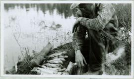
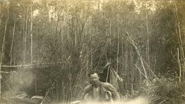
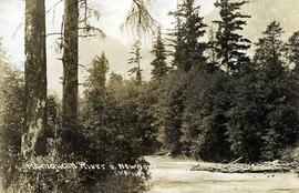
Image depicts a creek with a half collapsed shack in the background somewhere in Manson Creek. The slide is labelled "Manson workings."
Image depicts the gas station at Manson Creek, B.C.
Image depicts a man and his family filling up their truck with gas at Manson Creek, B.C.
Image depicts Manson Creek, B.C.
File contains slides depicting places in and around Manson Creek.
Photograph depicts a cleared path through the snow and trees, mountain in background. Wood box and post semi-visible in foreground. Handwritten annotation in blue ink on recto of photograph: "You will notice we have a little snow here."
Photograph depicts snowy mountaintop, wooden shelter and truck in foreground. Corresponding note on accompanying photo description page: "Pictures taken July 2nd, 1952. 1. Picture taken from campsite showing snow on talus."
Photograph depicts man standing on dirt road. Snowbank to right of man is almost shoulder-height and disappears as road continues. Corresponding note on accompanying photo description page: "12. Indicates snow along the mountain road."
Photograph depicts mountain side, semi-covered in snow, trees in foreground. Corresponding note on accompanying photo description page: "9. Shows snow conditions in second gully north of talus deposit. Same condition here but high crown can be seen [see item 2000.1.1.2.228]."
Photograph depicts mountain side, semi-covered in snow. Snowbank in foreground. Corresponding note on accompanying photo description page: "8. Shows snow conditions in gully just north of talus deposit on south slope. Note considerable snow still above road. Estimated depth of snow here to be from 10 to 20 feet [see also item 2000.1.1.2.229]."
Photograph depicts flat area mostly covered in snow. Corresponding note on accompanying photo description page: "11. Indicates snow conditions in the cirque. Taken from near first switchback."
Photograph depicts mountain side mostly covered in snow. Corresponding note on accompanying photo description page: "10. Snow on mountain slope above road between where mountain road starts and the first switchback. This snow will melt and the water must still pass over or along road."
Handwritten annotation below photo on page taped to photograph: "PHOTO #3 Showing approx. area covered by Asbestos - serpentine float". The approximate area has been outlined in blue ink on verso of photograph. Photo taken from lower level in valley, trees in foreground, outcrop visible in distance.
Photograph depicts a man kneeling by row of trout between two small logs on grassy bank of a water's shore. What appears to be the vertical handle of a knife is foregrounded at bottom of image. Handwritten caption below this photo reads: "Trout Fishing."
Photograph depicts a man with a helicopter at the location of the proposed powerhouse on Klemtu Lake.
Image depicts an unidentified man lighting a fire somewhere in South Tweedsmuir Provincial Park.
Image depicts an individual, possibly Kent Sedgwick, standing on a trail through a forest somewhere in or around Seton Portage, B.C.
Photograph depicts a man standing near a very large driftwood root.
Handwritten caption beside this photo reads: "Earth Cut". Photograph depicts a man in distance at top of steep slope of man-made embankment, trees in background. Tracks made my machinery are visible in dirt of the cut.
Handwritten caption above this photo reads: "Sumit Lake." Photograph depicts man sitting facing lake among branches of trees in foreground, forest on opposite shore reflected in water.
Photograph depicts one man seated in rear of canoe on still water. Trees on opposite shore in background. This man is believed to be a member of the Bourchier forestry crew.
Image depicts an unknown individual climbing the side of a large boulder.
Photograph depicts a man using crutches, this person wears glasses. There is a forest in the background.
Image depicts an unidentified man standing on a wood bridge somewhere in South Tweedsmuir Provincial Park.
Image depicts a man leaning on a rock somewhere on Murray Ridge.
Unidentified man can be seen walking on railroad tracks on far right. Utility poles, field, small building and background hills are visible in image.
Image depicts an unknown individual reading inside a tent somewhere in Mt. Robson Provincial Park.
Photograph depicts canoe floating in water, rocky shore in foreground, opposite shore visible on horizon.
Typed annotation on recto: "Tachi River, Stuart Lake, B.C." Man in tall hat, smoking from a pipe, and standing on shore with fishing rod extended over water. Tree-covered banks in background.
Typed annotation on recto: "Stuart Lake B.C." Man standing in water close to cliff which is reflected in water on right. Hills on opposite shore can be seen in background.
Typed annotation on recto: "Stuart Lake Scene - British Columbia." Man stands in water close to cliff which is reflected in water on right. Hills on opposite shore can be seen in background.
Photograph depicts a man bathing himself while standing in a small metal tub. Photograph description in album notes this as "His 'Semi Annual'" [bath]. On the left is a log structure, presumably a cache building. A large clearing surrounds the building and bathing man. There is a forest and bluff in the background. Possibly located near Giscome Portage.
Image depicts a man, possibly Kent Sedgwick, standing next to a monument which states: "In honour of the pioneers of the Ootsa Lake Valley, first settled in 1905." Located somewhere in either the Francois Lake Provincial Park or the Wistaria Provincial Park.
Image depicts a man, with what is possibly the Robson Glacier visible in the background.
Photograph depicts the Mamquam River near Squamish.
Item is a map annotated in colour by the City of Prince George Planning Department depicting major residential development proposals from June 1975 to August 1977 in the City of Prince George. This map was drawn for the City of Prince George interim Community Plan.
Photographs depict different construction projects at separate locations in Cassiar. Photographs were originally housed in envelopes with the following annotations: "POLICE STATION. July 15, 1977."; "Aggregates and Concrete (PERMASTEEL)"; "Fibre Storage and Handling"; "Powerhouse Expansion"; "Sewage Collection Plant."; "Sewage Treatment Plant"; "Single Person Accommodations - Site Work."; "Outside Work - Camp Nos. 1,2,3." Photos generally feature the work sites, supplies, vehicles, machinery, and work in progress at each location.
Additional photographs integrated into file include maintenance project on lining of tubes, lining of aspiration hood, and lining of willow fiberizer. Also five photographs of maintenance in the townsite to fix in ground piping.
Photograph depicts a view of main street Grand Forks BC.
Photograph depicts a view of main street Grand Forks, BC. There are power poles in the center of the photograph, buildings line the street
Photograph depicts a view of main street Grand Forks, BC.
Photograph depicts a billboard size sign on the side of a building in Grand Forks BC.
Photograph depicts a view of main street Grand Forks, BC.
Photograph depicts a group of men standing near a building with the sign, "James Reid Ltd. General Merchants". There are a few fences and buildings in the background.
Hand coloured photo of Main Street in Prince Rupert, with various tents and buildings on either side of the wooden road. Printed annotation on recto reads: "Main Street, Prince Rupert, B.C. : On comparatively Level Line London to Yokohama." Artist's mark on lower right corner reads: "104,035 J.V."
Photograph depicts the main street of Rolla with a dirt street and wooden sidewalks, tethered horses, and the storefront of H.G. Atkinson General Merchants. Three people are visible walking through the streets.
Image depicts several buildings along the main street in Stewart, B.C. One of them has been boarded up.
Image depicts several buildings along the main street in Stewart, B.C.
Image depicts the main street of Stewart, B.C.
File contains slides depicting places in and around Mackenzie Town.
Image depicts the Mackenzie Reservoir in Mackenzie, B.C.