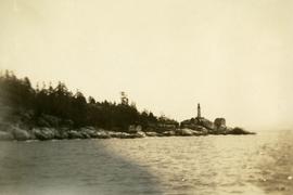
Photograph depicts a view from the ocean toward a lighthouse on a rocky ocean shore point. There are a few building near the lighthouse.
Image depicts numerous vehicles and individuals outside a hotel in Likely, B.C.
Image depicts a bridge, and the town of Likely on the the other side of a river.
File contains slides depicting places in and around the areas of Likely and Horsefly, B.C.
Image depicts a hotel in Likely, B.C.
Image depicts Lillooet, B.C.
Image depicts a view of Lillooet, B.C.
Image depicts two bridges over the Fraser River, located somewhere in Lillooet, B.C.
Image depicts some farmland in Lillooet, B.C.
File contains slides depicting places around and between Lillooet and Howe Sound.
Image depicts rows of water, possibly being irrigation ditches, somewhere in Lillooet, B.C.
Image depicts a view of the mountains surrounding Lillooet, B.C.
Image depicts a view of the Fraser River and the mountains surrounding Lillooet, B.C.
Image depicts an old church located somewhere in Lillooet, B.C.
File contains slides depicting places in the Lillooet area.
Photograph depicts a view of a river, possibly the Fraser River, canyon, mountains, and scrub land.
Image depicts an area around Lillooet, B.C. It is possibly the Fraser River running through the Moran Canyon.
Image depicts the Lillooet River at the head of Lillooet Lake.
Image depicts the Lillooet River delta at the head of Lillooet Lake.
Image depicts what is possibly the Lillooet River, full of driftwood.
Marsh along the edges of Eagle Lake features tall riparian plants and lily pads. Handwritten annotation in pen on verso reads: “Eagle Lake.”
Map depicts species of forest trees in British Columbia and their regional distribution.
Item is a photograph of the Lloyd Bros. Cluculz Lake Operation in April 1964.
View of a scow loaded with provisions and several people passing through rapids of the Grand Canyon. Printed annotation on recto reads: “A scow loaded with provisions passing through the Grand Canyon on it’s way to Fort George.” Handwritten annotation in pencil on recto reads: “Nearly Bumped, Nachaco River” Handwritten annotation in pencil on verso reads: “My address will be Fort George BC. Dear Mrs. Cooper, I am up in the wild part of BC now where men horses and everything get drowned every day, sometimes automobiles get drowned also. This is the way we travel up where I am now. I saw a boat upside down in this Canyon it had a bundle of blankets tied on it and one oar was dancing in the whirlpool. This made my hair stand straight up and down.”
Photograph depicts three or more men near a wagon loaded with supplies. A team of two or more horses are hitched to the wagon. Lake and rolling treed hills in the background.
Photograph depicts six men by building on shore. One man sits in small boat that has been loaded onto a wagon. River and opposite shore in background. Handwritten annotation on verso of photograph: "Loading for the Peace River." Photograph believed to have been taken either at Giscome Portage, or the trading post at Summit Lake, BC.
Photograph depicts a woman standing beside a car parked in front of the Lodge at Riske Creek in the Chilcotin. Lodge consists of a log structure which has an attached general store. Annotation on verso reads: "Risske [sic] Creek in the Chilcotin 1949".
Photograph depicts totem poles (crest poles?) in front of lodge buildings on river shore. Canoes can be seen floating in foreground, hills in background.
Handwritten annotation on verso reads: "Chapter XII. Number 1. Section of Indian Village on Nass River showing lodges and totems".
Lofty view of downtown Prince Rupert, with water and mountains in the background. Printed annotation on recto reads: "Prince Rupert, B.C."
Image depicts a log cabin and an orange truck somewhere in or near Longworth, B.C.
Photograph depicts a view of a log jam on the Kettle River from Billings siding.
Three men can be seen carrying bundles across bridge above river, forest on shore in background.
Handwritten annotation on verso reads: "Upper Nass River. Chapt. XXII. No. 4. An Indian Bridge on a canyon."
Photograph depicts a forested mountain, the bottom half of which has been logged and terraced; beneath the mountain is a railroad track and parked vehickes including a schoolbus and two dumptrucks.
Handwritten annotation on verso reads: “Fairview Sodturning, Prince Rupert, 1/3/75”.
Image depicts a logging area somewhere near Prince George, B.C.
Image depicts numerous piles of logs, and two unidentified individuals operating an excavator with a "thumb" attachment during the demolition of the Upper Fraser town site. Map coordinates 54°06'51.6"N 121°56'26.3"W
Image depicts a pile of old logs on the bank of the Fraser River with mountains in the background. In the foreground, a set of railway tracks run through an uncertain location, likely Upper Fraser, B.C.
Photograph depicts one unidentified man surveying a landscape from a snowy mountain peak with other mountain ranges in the background.
Slightly elevated photograph of Prince Rupert buildings. A lone vessel is visible in the background. Printed annotation on recto reads: "Courtesy of Can Nat'l Rys. Prince Rupert. B.C." Handwritten annotation on verso reads: "Dear Elma. We reached Prince Rupert (in the picture) today. Friday we arrive at Skagway and the glaciers. Having a fine trip- good weather and a good crowd. Love from Claire." Postcard is addressed to: "Mrs. Claude Millersh, River Forest, Guerneville, Sonoma Co., California." Postcard is affixed with a two cent American stamp. Postmark on verso reads: "Ketohikan Alaska. Jun 28 3 PM 1928."
Image depicts a house surrounded by trees and a mountain in the background; it is most likely located somewhere in or near Longworth, B.C.
Image depicts four unidentified individuals walking along the bank of the Fraser River in Longworth, B.C.
Image depicts numerous piles of wood in Longworth, B.C.
Image depicts two unidentified individuals standing next to the train station, and two railway tracks running through Longworth, B.C.
Image depicts the Fraser River and a mountain in Longworth, B.C.
Image depicts several old shacks and some railway tracks running through Longworth, B.C.
Image depicts the post office in Longworth, B.C.